Delwedd:-IDAHO-L-0011- Teton Dam Flood - Newdale (5811753523).jpg
Maint llawn ((2,657 × 1,798 picsel, maint y ffeil: 510 KB, ffurf MIME: image/jpeg))
.jpg)
Crynodeb
| Disgrifiad |
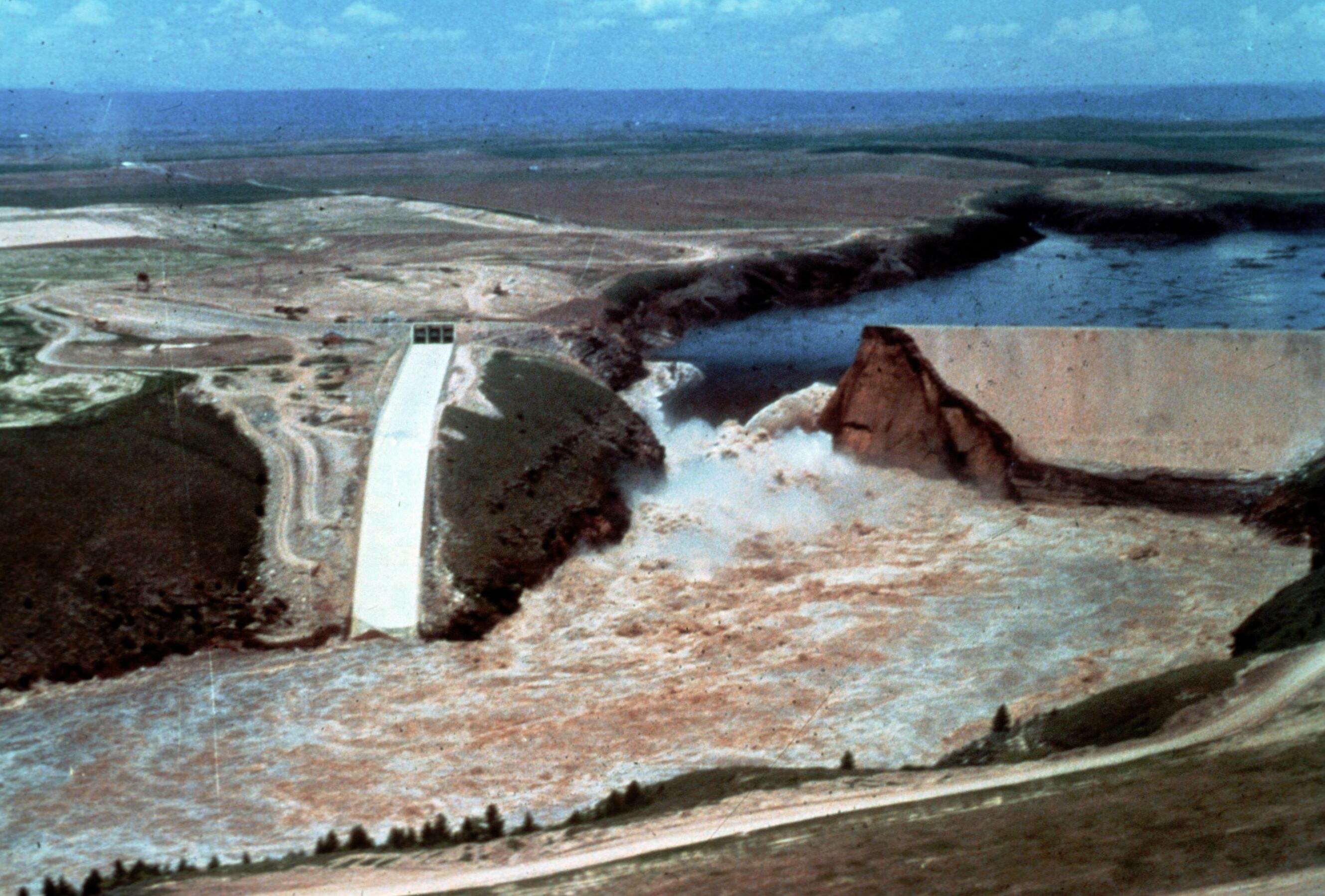
Image Title: Teton Dam Flood - Newdale Date: June 5, 1976 Place: Teton River, Newdale, Idaho Description/Caption: Progressive stages of break in the Dam. Statistics of interest: 80 billion gallons (220,000 acre feet) of water released. Floodwaters' path was seven miles wide in some places (average depth 8-10 feet). 100,000 acres of farmland stripped of topsoil; 13,000 head of livestock killed; 4000 homes, 50 businesses, 3500 farm buildings destroyed. Medium: color transparency Photographer/Maker: Bureau of Reclamation Cite as: ID-L-0011, WaterArchives.org Restrictions: There are no known U.S. copyright restrictions on this image. While the digital image is freely available, it is requested that <a href="http://www.waterarchives.org" target="browser" rel="nofollow">www.waterarchives.org</a> be credited as its source. For higher quality reproductions of the original physical version contact <a href="http://www.waterarchives.org" target="browser" rel="nofollow">www.waterarchives.org</a>, restrictions may apply. |
| Dyddiad | |
| Ffynhonnell | [IDAHO-L-0011] Teton Dam Flood - Newdale |
| Awdur | WaterArchives.org from Las Cruces, New Mexico, United States |
| Camera location | | View this and other nearby images on: OpenStreetMap |
|---|
.jpg¶ms=043.910113_N_-111.539983_E_globe:Earth_type:camera_source:Flickr_&language=cy)
Trwyddedu
- Mae'n rhydd i chi:
- rhannu – gallwch gopïo, dosbarthu a throsglwyddo'r gwaith
- ailwampio – gallwch addasu'r gwaith
- Ar yr amodau canlynol:
- cydnabyddiaeth – Mae'n rhaid i chi nodi manylion y gwaith hwn, rhoi dolen i'r drwydded, a nodi os y bu golygu arni, yn y modd a benwyd gan yr awdur neu'r trwyddedwr (ond heb awgrymu o gwbl eu bod yn eich cymeradwyo chi na'ch defnydd o'r gwaith).
- rhannu ar dermau tebyg – Os byddwch yn addasu'r gwaith hwn, neu yn ei drawsnewid, neu yn adeiladu arno, mae'n rhaid i chi ddosbarthu'r gwaith dan drwydded sy'n union yr un fath same a'r gwreiddiol.
| This image was originally posted to Flickr by waterarchives at https://flickr.com/photos/23487245@N08/5811753523. It was reviewed on 15 Mehefin 2020 by FlickreviewR 2 and was confirmed to be licensed under the terms of the cc-by-sa-2.0. |
Hanes y ffeil
Cliciwch ar ddyddiad / amser i weld y ffeil fel ag yr oedd bryd hynny.
| Dyddiad / Amser | Bawdlun | Hyd a lled | Defnyddiwr | Sylw | |
|---|---|---|---|---|---|
| cyfredol | 15:13, 4 Ebrill 2023 | | 2,657 × 1,798 (510 KB) | Rémih | Cropped 8 % horizontally, 7 % vertically using CropTool with precise mode. |
| 09:48, 15 Mehefin 2020 |  | 2,882 × 1,940 (548 KB) | Kingofthedead | Transferred from Flickr via #flickr2commons |
Cysylltiadau'r ffeil
Mae'r 1 tudalennau a ddefnyddir isod yn cysylltu i'r ddelwedd hon:
Defnydd cydwici y ffeil
Mae'r wicis eraill hyn yn defnyddio'r ffeil hon:
- Y defnydd ar ar.wikipedia.org
- Y defnydd ar arz.wikipedia.org
- Y defnydd ar bg.wikipedia.org
- Y defnydd ar ca.wikipedia.org
- Y defnydd ar ce.wikipedia.org
- Y defnydd ar es.wikipedia.org
- Y defnydd ar eu.wikipedia.org
- Y defnydd ar fr.wikipedia.org
- Y defnydd ar ht.wikipedia.org
- Y defnydd ar it.wikipedia.org
- Y defnydd ar ky.wikipedia.org
- Y defnydd ar lld.wikipedia.org
- Y defnydd ar no.wikipedia.org
- Y defnydd ar oc.wikipedia.org
- Y defnydd ar pl.wikipedia.org
- Y defnydd ar sr.wikipedia.org
- Y defnydd ar tt.wikipedia.org
- Y defnydd ar uk.wikipedia.org
- Y defnydd ar uz.wikipedia.org
- Y defnydd ar www.wikidata.org
.jpg)