Delwedd:2017 UK local elections - Ward and Council Control.svg

Maint rhagolwg PNG o ffeil SVG yw: 706 × 599 picsel. Eglurdebau eraill: 283 × 240 picsel | 565 × 480 picsel | 905 × 768 picsel | 1,206 × 1,024 picsel | 2,412 × 2,048 picsel | 967 × 821 picsel.
Maint llawn (Ffeil SVG, maint mewn enw 967 × 821 picsel, maint y ffeil: 13.23 MB)
Crynodeb
| Disgrifiad |
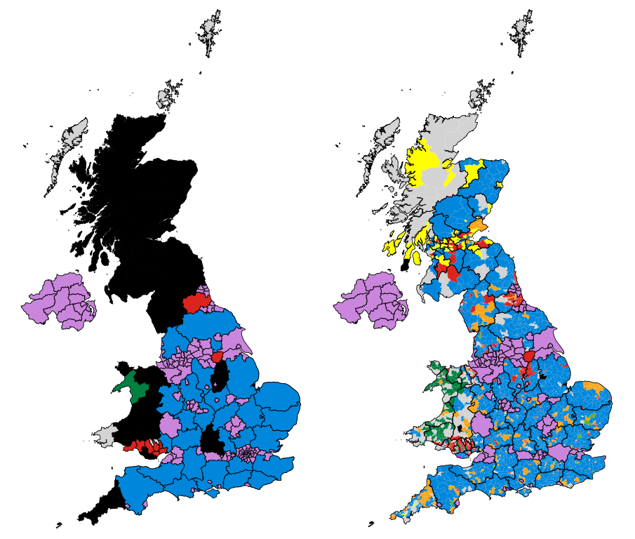
English: Map of the results of the 2017 UK local elections, showing party control by council (left), and the most popular party by ward (right). |
| Dyddiad | |
| Ffynhonnell | Gwaith yr uwchlwythwr. Map made utilising data from the Ordnance Survey & Local Government Boundary Commission in Scotland. Council control based on information from the BBC - Scotland, England, Wales. Ward results are from individual councils. |
| Awdur | MrPenguin20 |
Trwyddedu
Yr wyf fi, deiliad yr hawlfraint ar y gwaith hwn, yn ei gyhoeddi yn ôl termau'r drwydded a ganlyn:
Trwyddedir y ffeil hon yn ôl termau'r drwydded Creative Commons Attribution-Share Alike 4.0 International.
- Mae'n rhydd i chi:
- rhannu – gallwch gopïo, dosbarthu a throsglwyddo'r gwaith
- ailwampio – gallwch addasu'r gwaith
- Ar yr amodau canlynol:
- cydnabyddiaeth – Mae'n rhaid i chi nodi manylion y gwaith hwn, rhoi dolen i'r drwydded, a nodi os y bu golygu arni, yn y modd a benwyd gan yr awdur neu'r trwyddedwr (ond heb awgrymu o gwbl eu bod yn eich cymeradwyo chi na'ch defnydd o'r gwaith).
- rhannu ar dermau tebyg – Os byddwch yn addasu'r gwaith hwn, neu yn ei drawsnewid, neu yn adeiladu arno, mae'n rhaid i chi ddosbarthu'r gwaith dan drwydded sy'n union yr un fath same a'r gwreiddiol.
This file is licensed by the Ordnance Survey of the United Kingdom under their OS OpenData License
In short: you are free to distribute and modify the file as long as you attribute (including year), the Ordnance Survey. Cydnabyddiaeth: Contains Ordnance Survey data © Crown copyright and database right (year) Note: Derivative works can be licensed under any Creative Commons Attribution 3.0 Licence. |
.svg)
|
This file is licensed under the United Kingdom Open Government Licence v3.0. |
See also: Meta for information on usage on Wikimedia wikis.
|
Hanes y ffeil
Cliciwch ar ddyddiad / amser i weld y ffeil fel ag yr oedd bryd hynny.
| Dyddiad / Amser | Bawdlun | Hyd a lled | Defnyddiwr | Sylw | |
|---|---|---|---|---|---|
| cyfredol | 22:23, 29 Ionawr 2018 | | 967 × 821 (13.23 MB) | MrPenguin20 | Completed last several councils. |
| 18:17, 10 Tachwedd 2017 |  | 967 × 821 (13.22 MB) | Into oblivion | Added 'West Sussex' and 'Wiltshire' areas | |
| 22:10, 9 Mai 2017 |  | 967 × 821 (13.22 MB) | Renamed user OCfxJKu7j2 | Scottish results | |
| 18:36, 9 Mai 2017 |  | 967 × 821 (13.22 MB) | MrPenguin20 | Updated Wales. | |
| 10:16, 7 Mai 2017 |  | 967 × 821 (13.21 MB) | MrPenguin20 | Durham - although will have to double check voter figures for some wards with split representation. | |
| 02:09, 7 Mai 2017 |  | 967 × 821 (13.21 MB) | Into oblivion | Added 'East Sussex' and 'Cardiff' areas | |
| 20:21, 6 Mai 2017 |  | 967 × 821 (13.19 MB) | MrPenguin20 | More results. | |
| 18:30, 6 Mai 2017 |  | 967 × 821 (13.18 MB) | MrPenguin20 | More results. | |
| 23:33, 5 Mai 2017 |  | 967 × 821 (13.18 MB) | MrPenguin20 | More ward results. | |
| 23:06, 5 Mai 2017 |  | 967 × 821 (13.17 MB) | MrPenguin20 | Updates. |
Cysylltiadau'r ffeil
Mae'r 1 tudalennau a ddefnyddir isod yn cysylltu i'r ddelwedd hon:
Defnydd cydwici y ffeil
Mae'r wicis eraill hyn yn defnyddio'r ffeil hon:
- Y defnydd ar en.wikipedia.org
- Y defnydd ar fr.wikipedia.org
- Y defnydd ar zh.wikipedia.org