Delwedd:Aerial view of Hadleigh centre in the snow - geograph.org.uk - 1563668.jpg
Wedi ei chwyddo hyd yr eithaf.
Aerial_view_of_Hadleigh_centre_in_the_snow_-_geograph.org.uk_-_1563668.jpg ((640 × 503 picsel, maint y ffeil: 301 KB, ffurf MIME: image/jpeg))
Crynodeb
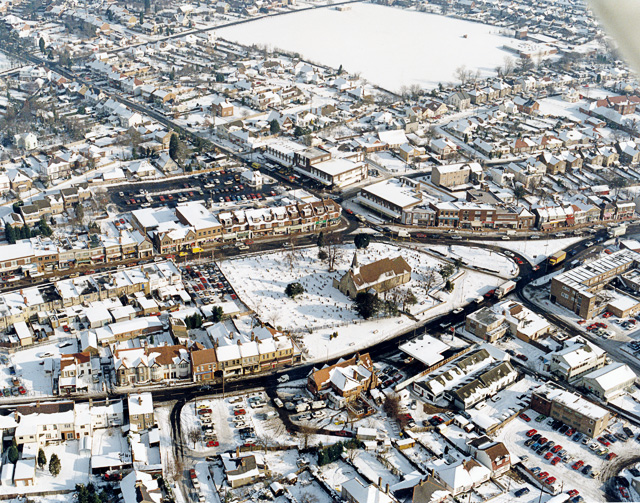
| Disgrifiad |
English: Aerial view of Hadleigh centre in the snow The church in the middle of the picture is St James-the-less. The large building below left of this is The Castle pub. Most of the buildings lining the major roads here are shops. The large white rectangle at the top is a school playing field, with the school to the right. |
| Dyddiad | |
| Ffynhonnell | From geograph.org.uk |
| Awdur | Edward Clack |
| Cydnabyddiaeth (required by the license) | Edward Clack / Aerial view of Hadleigh centre in the snow / |
| Camera location | | View this and other nearby images on: OpenStreetMap |
|---|
_heading:67.00&language=cy)
| Object location | | View this and other nearby images on: OpenStreetMap |
|---|
_heading:67.00&language=cy)
Trwyddedu

|
This image was taken from the Geograph project collection. See this photograph's page on the Geograph website for the photographer's contact details. The copyright on this image is owned by Edward Clack and is licensed for reuse under the Creative Commons Attribution-ShareAlike 2.0 license.
|
Trwyddedir y ffeil hon yn ôl termau'r drwydded Creative Commons Attribution-Share Alike 2.0 Generic.
Cydnabyddiaeth: Edward Clack
- Mae'n rhydd i chi:
- rhannu – gallwch gopïo, dosbarthu a throsglwyddo'r gwaith
- ailwampio – gallwch addasu'r gwaith
- Ar yr amodau canlynol:
- cydnabyddiaeth – Mae'n rhaid i chi nodi manylion y gwaith hwn, rhoi dolen i'r drwydded, a nodi os y bu golygu arni, yn y modd a benwyd gan yr awdur neu'r trwyddedwr (ond heb awgrymu o gwbl eu bod yn eich cymeradwyo chi na'ch defnydd o'r gwaith).
- rhannu ar dermau tebyg – Os byddwch yn addasu'r gwaith hwn, neu yn ei drawsnewid, neu yn adeiladu arno, mae'n rhaid i chi ddosbarthu'r gwaith dan drwydded sy'n union yr un fath same a'r gwreiddiol.
Hanes y ffeil
Cliciwch ar ddyddiad / amser i weld y ffeil fel ag yr oedd bryd hynny.
| Dyddiad / Amser | Bawdlun | Hyd a lled | Defnyddiwr | Sylw | |
|---|---|---|---|---|---|
| cyfredol | 16:01, 3 Mawrth 2011 | | 640 × 503 (301 KB) | GeographBot | == {{int:filedesc}} == {{Information |description={{en|1=Aerial view of Hadleigh centre in the snow The church in the middle of the picture is St James-the-less. The large building below left of this is The Castle pub. Most of the buildings lining the maj |
Cysylltiadau'r ffeil
Mae'r 1 tudalennau a ddefnyddir isod yn cysylltu i'r ddelwedd hon:
Defnydd cydwici y ffeil
Mae'r wicis eraill hyn yn defnyddio'r ffeil hon:
- Y defnydd ar af.wikipedia.org
- Y defnydd ar azb.wikipedia.org
- Y defnydd ar ceb.wikipedia.org
- Y defnydd ar en.wikipedia.org
- Y defnydd ar fa.wikipedia.org
- Y defnydd ar fr.wikipedia.org
- Y defnydd ar ga.wikipedia.org
- Y defnydd ar it.wikipedia.org
- Y defnydd ar lld.wikipedia.org
- Y defnydd ar nl.wikipedia.org
- Y defnydd ar sv.wikipedia.org
- Y defnydd ar vo.wikipedia.org
- Y defnydd ar www.wikidata.org