Delwedd:Arad Josephinische Landesaufnahme pg24-27.jpg

Maint y rhagolwg: 800 × 534 picsel. Eglurdebau eraill: 320 × 214 picsel | 640 × 427 picsel | 1,024 × 683 picsel | 1,280 × 854 picsel | 2,560 × 1,709 picsel | 8,570 × 5,720 picsel.
Maint llawn ((8,570 × 5,720 picsel, maint y ffeil: 27.94 MB, ffurf MIME: image/jpeg))
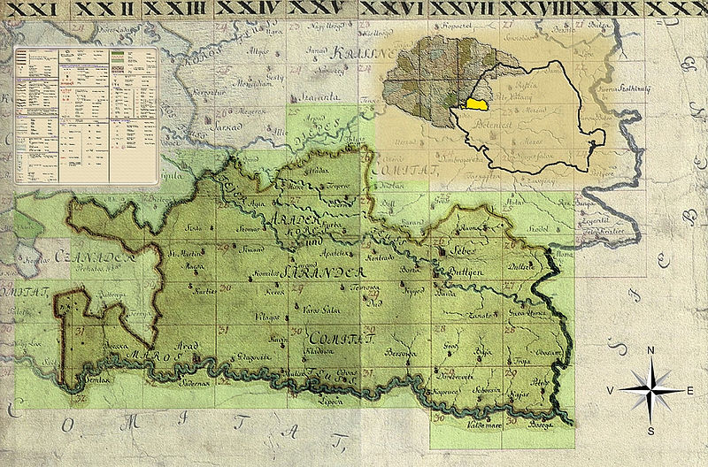
| Name shown on the map Nume din hartă |
Administrative unit Unitate administrativă |
Romanian name Numele românesc |
Hungarian name Numele unguresc |
German name Numele german |
Country today Ţara de astăzi |
|---|---|---|---|---|---|
| Bel Zerénd | Bihar Bihar vármegye Comitatul Bihor Komitat Bihar |
Zerindu Mic [Belzerind, Luntreni] | Bélzerénd, Bélzerind, Bélselénd, Kiszerind, Zerind | Romania | |
| Fekete Gyarmat | Arad Arad vármegye Comitatul Arad Komitat Arad |
Iermata Neagră | Feketegyarmat, Gyarmat | Romania | |
| Miske | Arad | Mişca | Tőzmiske, Miske | Romania | |
| Nagy Zerénd | Arad | Zerind [Zerindul Mare] | Nagyzerénd, Nagyzerind, Nagyselénd, Zerind | Romania | |
| Ond | Bihar | Ant | Ant | Romania | |
| Tamásda | Bihar | Tămaşda | Tamáshida, Tamásd | Romania |
Crynodeb
| Disgrifiad |
English: Kingdom of Hungary, 1782-85. Josephinische Landesaufnahme pg.24-27. Counties shown on the map: 1. Bihar County 2. Bekeser County 3. Arad County Română: Harta Iosefină a Regatului Ungariei, 1782-85. Josephinische Landesaufnahme pg.24-27. Comitate prezentate pe hartă: 1. Comitatul Bihor 2. Comitatul Bichiş 3. Comitatul Arad |
||||
| Dyddiad | 1782 - 1785 | ||||
| Ffynhonnell | Österreichisches Staatsarchiv, Kriegsarchiv | ||||
| Awdur | Historische Militärkarte der österreichisch-ungarischen Monarchie | ||||
| Caniatâd (Ailddefnyddio'r ffeil hon) |
|
||||
Clickable Map of the Arad County
Hanes y ffeil
Cliciwch ar ddyddiad / amser i weld y ffeil fel ag yr oedd bryd hynny.
| Dyddiad / Amser | Bawdlun | Hyd a lled | Defnyddiwr | Sylw | |
|---|---|---|---|---|---|
| cyfredol | 07:09, 1 Ebrill 2010 | | 8,570 × 5,720 (27.94 MB) | Asybaris01 | {{Information |Description={{ro|1=Arad Josephinische Landesaufnahme pg24-27}} |Source={{own}} |Author=Asybaris01 |Date=1782-1785 |Permission= |other_versions= }} Category:Josephinische Landaufnahme |
Cysylltiadau'r ffeil
Nid oes tudalennau'n defnyddio'r ffeil hon.
Defnydd cydwici y ffeil
Mae'r wicis eraill hyn yn defnyddio'r ffeil hon:
- Y defnydd ar arz.wikipedia.org
- Y defnydd ar de.wikipedia.org
- Y defnydd ar hu.wikipedia.org
- Y defnydd ar ro.wikipedia.org
- Y defnydd ar tt.wikipedia.org
- Y defnydd ar www.wikidata.org