Delwedd:Archipel de Brehat.jpg

Maint y rhagolwg: 800 × 509 picsel. Eglurdebau eraill: 320 × 203 picsel | 640 × 407 picsel | 1,178 × 749 picsel.
Maint llawn ((1,178 × 749 picsel, maint y ffeil: 161 KB, ffurf MIME: image/jpeg))
| Disgrifiad |
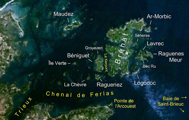
Deutsch: Satellitenbild der Inselgruppe Bréhat. Die Namen der Inseln sind weißgeschrieben, andere Angaben gelb.
Français : Image de satellite de l'archipel de Bréhat |
| Dyddiad | screenshot from World Wind on 26 May 2007 |
| Ffynhonnell | NASA World Wind (see below); edited using the Gimp |
| Awdur | NASA; editing by User:Ibn Battuta |
| This image is in the public domain because it is a screenshot from NASA’s globe software World Wind using a public domain layer, such as Blue Marble, MODIS, Landsat, SRTM, USGS or GLOBE.
|
 |
Hanes y ffeil
Cliciwch ar ddyddiad / amser i weld y ffeil fel ag yr oedd bryd hynny.
| Dyddiad / Amser | Bawdlun | Hyd a lled | Defnyddiwr | Sylw | |
|---|---|---|---|---|---|
| cyfredol | 21:43, 26 Mai 2007 | | 1,178 × 749 (161 KB) | Ibn Battuta | {{Information |Description={{de|Satellitenbild der Inselgruppe Bréhat. Die Namen der Inseln sind weißgeschrieben andere Angaben gelb.}} {{fr|Image de satellite de l'archipel de Bréhat}} |Source=NA |
Cysylltiadau'r ffeil
Mae'r 1 tudalennau a ddefnyddir isod yn cysylltu i'r ddelwedd hon:
Defnydd cydwici y ffeil
Mae'r wicis eraill hyn yn defnyddio'r ffeil hon:
- Y defnydd ar br.wikipedia.org
- Y defnydd ar ca.wikipedia.org
- Y defnydd ar de.wikipedia.org
- Y defnydd ar eo.wikipedia.org
- Y defnydd ar eu.wikipedia.org
- Y defnydd ar fr.wikipedia.org
- Y defnydd ar www.wikidata.org
- Y defnydd ar zh.wikipedia.org