Delwedd:B26055943A - A map of the East-Indies and the adjacent countries.jpg

Maint y rhagolwg: 800 × 509 picsel. Eglurdebau eraill: 320 × 204 picsel | 640 × 407 picsel | 1,024 × 652 picsel | 1,280 × 815 picsel | 2,560 × 1,629 picsel | 7,509 × 4,779 picsel.
Maint llawn ((7,509 × 4,779 picsel, maint y ffeil: 12.73 MB, ffurf MIME: image/jpeg))
Crynodeb
| Disgrifiad |
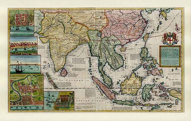
English: This large map by Herman Moll shows the East Indies from the Persian border to New Guinea and the southern part of Japan, including India, Ceylon, southeast Asia, most of China, Indonesia and the Philippines. It illustrates the extent of European influence and trade in the region, at the height of European colonial control. Further map features and detail maps of interest: Batavia, Goa, Mughal Empire, Maldives, Chennai, Banten, Lake Chimay |
| Dyddiad | |
| Ffynhonnell | NLB Singapore, David Parry Southeast Asian Map Collection. Available on BookSG https://eresources.nlb.gov.sg/printheritage/detail/3957ca10-8863-4f87-9d8c-49cfe590b0cd.aspx |
| Awdur | Moll, Herman, -1732 |
| Diwygiadau eraill |


Trwyddedu
| Trwyddedir y ffeil hon yn ôl termau'r drwydded Creative Commons CC0 1.0 Universal Public Domain Dedication. | |
| Wrth gysylltu rhyw waith â'r weithred gyfreithiol hon, mae'r person a'i gysylltodd wedi ei gyflwyno i'r parth cyhoeddus gan ildio pob hawl cyfraith hawlfraint arno yn fydeang, gan gynnwys pob hawl perthynol a chyfagos, hyd eithaf y gyfraith. Gallwch gopïo, addasu, dosbarthu a pherfformio'r gwaith, hyd yn oed at bwrpas masnachol, a hynny oll heb ofyn caniatad.
|
Hanes y ffeil
Cliciwch ar ddyddiad / amser i weld y ffeil fel ag yr oedd bryd hynny.
| Dyddiad / Amser | Bawdlun | Hyd a lled | Defnyddiwr | Sylw | |
|---|---|---|---|---|---|
| cyfredol | 05:13, 28 Rhagfyr 2021 | | 7,509 × 4,779 (12.73 MB) | NLSingapore | Uploaded a work by Moll, Herman, -1732 from NLB Singapore, David Parry Southeast Asian Map Collection. Available on BookSG https://eresources.nlb.gov.sg/printheritage/detail/3957ca10-8863-4f87-9d8c-49cfe590b0cd.aspx with UploadWizard |
Cysylltiadau'r ffeil
Mae'r 1 tudalennau a ddefnyddir isod yn cysylltu i'r ddelwedd hon:
Defnydd cydwici y ffeil
Mae'r wicis eraill hyn yn defnyddio'r ffeil hon:
- Y defnydd ar ar.wikipedia.org
- Y defnydd ar ast.wikipedia.org
- Y defnydd ar az.wikipedia.org
- Y defnydd ar be.wikipedia.org
- Y defnydd ar bg.wikipedia.org
- Y defnydd ar br.wikipedia.org
- Y defnydd ar ca.wikipedia.org
- Y defnydd ar el.wikipedia.org
- Y defnydd ar eo.wikipedia.org
- Y defnydd ar eu.wikipedia.org
- Y defnydd ar fr.wikipedia.org
- Y defnydd ar ga.wikipedia.org
- Y defnydd ar he.wikipedia.org
- Y defnydd ar hy.wikipedia.org
- Y defnydd ar it.wikipedia.org
- Y defnydd ar uk.wikipedia.org
- Y defnydd ar www.wikidata.org