Delwedd:BatmanDam-July2012-01.JPG

Maint y rhagolwg: 800 × 450 picsel. Eglurdebau eraill: 320 × 180 picsel | 640 × 360 picsel | 1,024 × 576 picsel | 1,280 × 720 picsel | 2,366 × 1,330 picsel.
Maint llawn ((2,366 × 1,330 picsel, maint y ffeil: 1.27 MB, ffurf MIME: image/jpeg))
Crynodeb
| Disgrifiad |
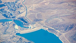
English: Aerial view of the Batman Dam, Turkey. |
| Dyddiad | |
| Ffynhonnell | Gwaith yr uwchlwythwr |
| Awdur | Rehman Abubakr |
| Object location | | View this and other nearby images on: OpenStreetMap |
|---|
Trwyddedu

|
This image has been assessed under the valued image criteria and is considered the most valued image on Commons within the scope: Batman Dam. You can see its nomination here. |
Hanes y ffeil
Cliciwch ar ddyddiad / amser i weld y ffeil fel ag yr oedd bryd hynny.
| Dyddiad / Amser | Bawdlun | Hyd a lled | Defnyddiwr | Sylw | |
|---|---|---|---|---|---|
| cyfredol | 09:52, 21 Mehefin 2015 | | 2,366 × 1,330 (1.27 MB) | Rehman | User created page with UploadWizard |
Cysylltiadau'r ffeil
Mae'r 1 tudalennau a ddefnyddir isod yn cysylltu i'r ddelwedd hon:
Defnydd cydwici y ffeil
Mae'r wicis eraill hyn yn defnyddio'r ffeil hon:
- Y defnydd ar ar.wikipedia.org
- Y defnydd ar arz.wikipedia.org
- Y defnydd ar ceb.wikipedia.org
- Y defnydd ar en.wikipedia.org
- Y defnydd ar en.wiktionary.org
- Y defnydd ar fa.wikipedia.org
- Y defnydd ar fr.wikipedia.org
- Y defnydd ar he.wikipedia.org
- Y defnydd ar hy.wikipedia.org
- Y defnydd ar hyw.wikipedia.org
- Y defnydd ar pl.wikipedia.org
- Y defnydd ar sh.wikipedia.org
- Y defnydd ar www.wikidata.org