Delwedd:BlueLine.jpg
Maint y rhagolwg: 800 × 553 picsel. Eglurdebau eraill: 320 × 221 picsel | 640 × 442 picsel | 1,024 × 708 picsel | 1,299 × 898 picsel.
Maint llawn ((1,299 × 898 picsel, maint y ffeil: 157 KB, ffurf MIME: image/jpeg))
Crynodeb
| Disgrifiad |
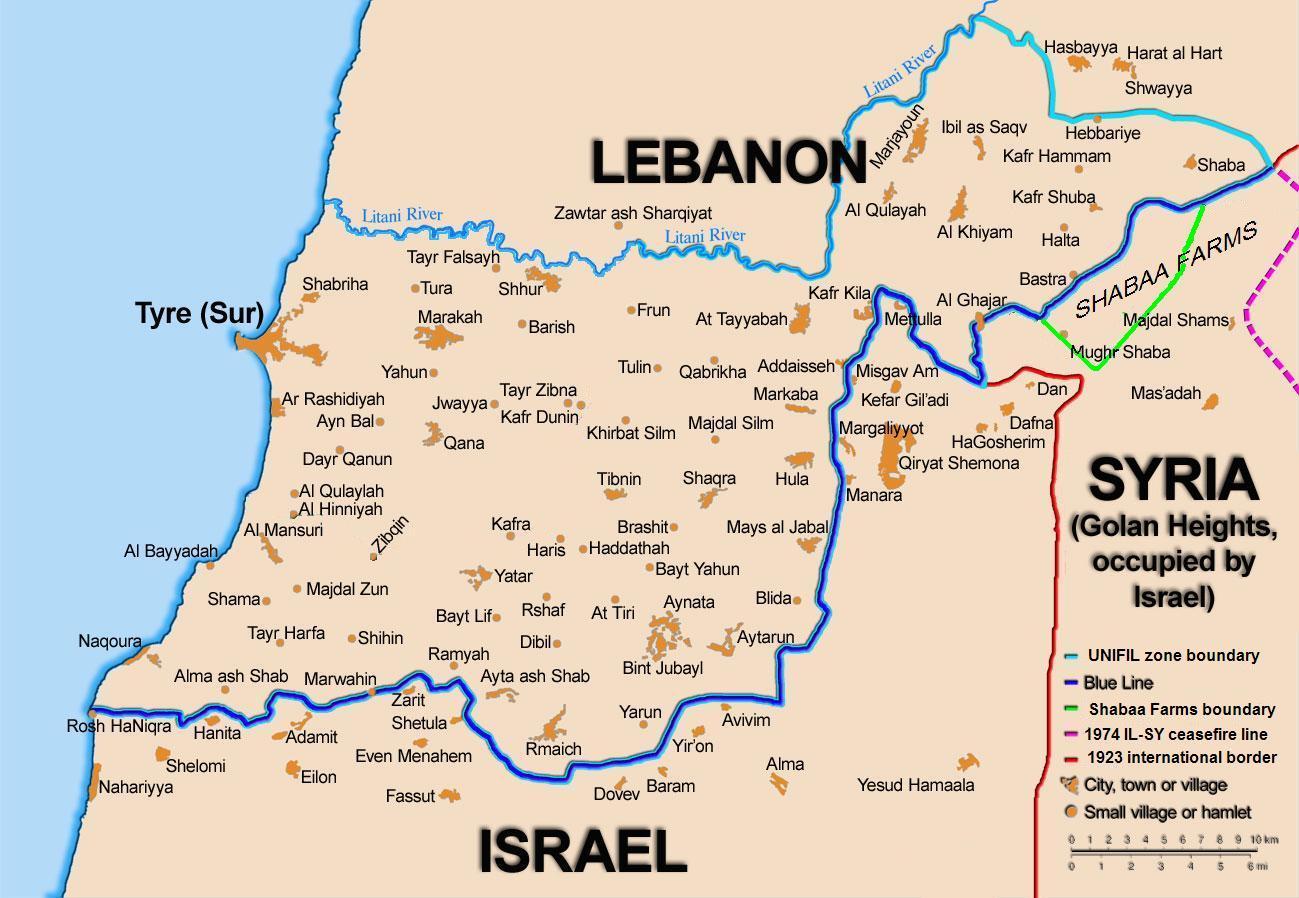
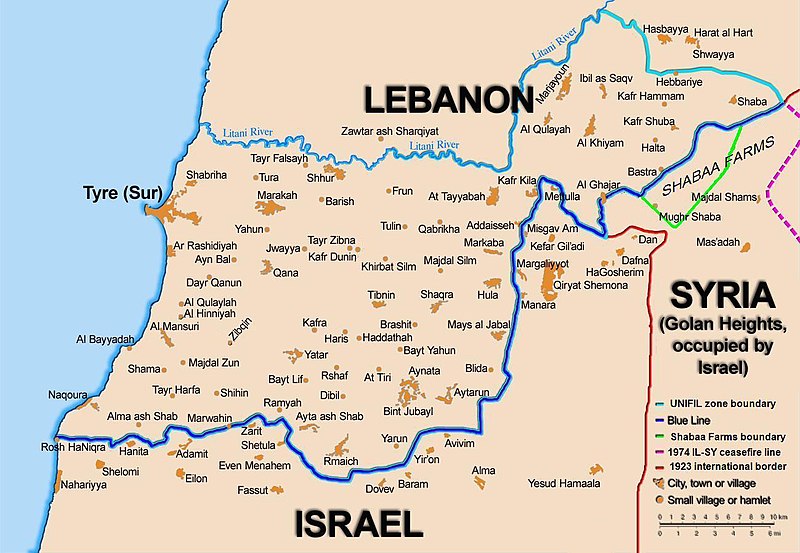
English: Map showing the Blue Line demarcation line between Lebanon and Israel, established by the UN after the Israeli withdrawal from southern Lebanon after its short 1978 invasion called Operation Litani. It follows the 1949 cease-fire line, also known as the Green Line, as well as the somewhat contested Lebanese-Syrian border towards the Israeli-occupied Golan Heights. |
| Dyddiad | short 1978 the 1949 July 2006 the 2006 |
| Ffynhonnell | Self-published work by 99of9 |
| Awdur | 99of9 / * The map is made by Thomas Blomberg using the UNIFIL map, deployment as of July 2006 as source. |
| Diwygiadau eraill |
|


|
This map image could be re-created using vector graphics as an SVG file. This has several advantages; see Commons:Media for cleanup for more information. If an SVG form of this image is available, please upload it and afterwards replace this template with
{{vector version available|new image name}}.
It is recommended to name the SVG file “BlueLine.svg”—then the template Vector version available (or Vva) does not need the new image name parameter. |


Trwyddedu
Yr wyf fi, deiliad yr hawlfraint ar y gwaith hwn, yn ei gyhoeddi yn ôl termau'r drwydded a ganlyn:
Trwyddedir y ffeil hon yn ôl termau'r drwydded Creative Commons Attribution-Share Alike 2.5 Generic.
- Mae'n rhydd i chi:
- rhannu – gallwch gopïo, dosbarthu a throsglwyddo'r gwaith
- ailwampio – gallwch addasu'r gwaith
- Ar yr amodau canlynol:
- cydnabyddiaeth – Mae'n rhaid i chi nodi manylion y gwaith hwn, rhoi dolen i'r drwydded, a nodi os y bu golygu arni, yn y modd a benwyd gan yr awdur neu'r trwyddedwr (ond heb awgrymu o gwbl eu bod yn eich cymeradwyo chi na'ch defnydd o'r gwaith).
- rhannu ar dermau tebyg – Os byddwch yn addasu'r gwaith hwn, neu yn ei drawsnewid, neu yn adeiladu arno, mae'n rhaid i chi ddosbarthu'r gwaith dan drwydded sy'n union yr un fath same a'r gwreiddiol.
Hanes y ffeil
Cliciwch ar ddyddiad / amser i weld y ffeil fel ag yr oedd bryd hynny.
| Dyddiad / Amser | Bawdlun | Hyd a lled | Defnyddiwr | Sylw | |
|---|---|---|---|---|---|
| cyfredol | 10:44, 16 Tachwedd 2010 | | 1,299 × 898 (157 KB) | 99of9 | Reverted to version as of 20:09, 21 October 2010. These boundaries appear to be accepted by both "sides" of the war. Their difference is over the label SYRIA (occupied...) over Golan Heights. For that we are now consistent with the original uploader's |
| 20:09, 21 Hydref 2010 |  | 1,299 × 898 (157 KB) | Nableezy | keep boundary changes but restore label for syria | |
| 16:30, 17 Awst 2006 |  | 1,299 × 898 (238 KB) | Thomas Blomberg | ||
| 14:16, 4 Awst 2006 |  | 1,299 × 898 (643 KB) | Thomas Blomberg | Map showing the Blue Line demarkation line between Lebanon and Israel, established by the UN after the Israeli withdrawal from southern Lebanon after its short 1978 invasion called "Operation Litani". It follows the 1949 cease-fire line, also known as the |
Cysylltiadau'r ffeil
Mae'r 1 tudalennau a ddefnyddir isod yn cysylltu i'r ddelwedd hon:
Defnydd cydwici y ffeil
Mae'r wicis eraill hyn yn defnyddio'r ffeil hon:
- Y defnydd ar ar.wikipedia.org
- Y defnydd ar ast.wikipedia.org
- Y defnydd ar azb.wikipedia.org
- Y defnydd ar ca.wikipedia.org
- Operació Litani
- Conflicte Israel-Líban
- Història del Líban
- Resolució 262 del Consell de Seguretat de les Nacions Unides
- Resolució 279 del Consell de Seguretat de les Nacions Unides
- Resolució 313 del Consell de Seguretat de les Nacions Unides
- Resolució 317 del Consell de Seguretat de les Nacions Unides
- Resolució 337 del Consell de Seguretat de les Nacions Unides
- Resolució 427 del Consell de Seguretat de les Nacions Unides
- Resolució 425 del Consell de Seguretat de les Nacions Unides
- Resolució 434 del Consell de Seguretat de les Nacions Unides
- Resolució 444 del Consell de Seguretat de les Nacions Unides
- Resolució 501 del Consell de Seguretat de les Nacions Unides
- Resolució 519 del Consell de Seguretat de les Nacions Unides
- Resolució 659 del Consell de Seguretat de les Nacions Unides
- Resolució 938 del Consell de Seguretat de les Nacions Unides
- Resolució 1122 del Consell de Seguretat de les Nacions Unides
- Resolució 1525 del Consell de Seguretat de les Nacions Unides
- Resolució 1655 del Consell de Seguretat de les Nacions Unides
- Resolució 1697 del Consell de Seguretat de les Nacions Unides
- Resolució 1773 del Consell de Seguretat de les Nacions Unides
- Y defnydd ar ckb.wikipedia.org
- بڕیارنامەی ٤٢٦ی ئەنجومەنی ئاسایش
- بڕیارنامەی ٤٢٧ی ئەنجومەنی ئاسایش
- بڕیارنامەی ٤٣٤ی ئەنجومەنی ئاسایش
- بڕیارنامەی ٤٤٤ی ئەنجومەنی ئاسایش
- بڕیارنامەی ٥٠١ی ئەنجومەنی ئاسایش
- بڕیارنامەی ٥١١ی ئەنجومەنی ئاسایش
- بڕیارنامەی ٥١٩ی ئەنجومەنی ئاسایش
- بڕیارنامەی ٦٥٩ی ئەنجومەنی ئاسایش
- بڕیارنامەی ١١٢٢ی ئەنجومەنی ئاسایش
- بڕیارنامەی ١٥٢٥ی ئەنجومەنی ئاسایش
- بڕیارنامەی ١٦٥٥ی ئەنجومەنی ئاسایش
- Y defnydd ar de.wikipedia.org
- Y defnydd ar el.wikipedia.org
- Y defnydd ar en.wikipedia.org
Gweld rhagor o'r defnydd cydwici o'r ffeil hon.