Delwedd:British Isles.svg

Maint rhagolwg PNG o ffeil SVG yw: 361 × 600 picsel. Eglurdebau eraill: 144 × 240 picsel | 289 × 480 picsel | 462 × 768 picsel | 616 × 1,024 picsel | 1,232 × 2,048 picsel | 1,300 × 2,160 picsel.
Maint llawn (Ffeil SVG, maint mewn enw 1,300 × 2,160 picsel, maint y ffeil: 154 KB)
Crynodeb
| Disgrifiad |
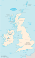
An SVG map of the British Isles, with the largest islands and archipelagos labelled. Always considered part of the British Isles
Sometimes considered part of the British Isles
Other lands |
| Ffynhonnell | Gwaith yr uwchlwythwr |
| Awdur | Smurrayinchester |
| SVG genesis | This W3C-invalid map was created with unknown tool. This map is translated using SVG switch elements: all translations are stored in the same file. |
}
Trwyddedu
Yr wyf fi, deiliad yr hawlfraint ar y gwaith hwn, yn ei gyhoeddi yn ôl termau'r drwydded a ganlyn:

|
Caniateir copïo, dosbarthu a/neu golygu'r ddogfen hon yn ôl telerau'r Drwydded Ddogfennaeth Rydd GNU, Fersiwn 1.2 neu unrhyw fersiwn diweddarach a gyhoeddwyd gan y Free Software Foundation; yn cynnwys dim Adrannau Di-syfl, dim Testunau Clawr Blaen, a dim Testunau Clawr Cefn. Cynhwysir copi o'r drwydded hon yn yr adran Trwydded Ddogfennaeth Rydd GNU". |
| Trwyddedir y ffeil hon yn ôl termau'r drwydded Creative Commons Attribution-Share Alike 3.0 Unported. | ||
| ||
| Ychwangwyd y nod trwyddedu hwn wrth y ffeil hon yn ran o'r gwaith o ddiweddaru trwyddedau GFDL. |
Derivative works
-
 македонски
 -
 Flag map (1801–1922)


derivative works
Derivative works of this file: British Isles mk.svg
Hanes y ffeil
Cliciwch ar ddyddiad / amser i weld y ffeil fel ag yr oedd bryd hynny.
| Dyddiad / Amser | Bawdlun | Hyd a lled | Defnyddiwr | Sylw | |
|---|---|---|---|---|---|
| cyfredol | 15:33, 10 Chwefror 2019 | | 1,300 × 2,160 (154 KB) | MSG17 | Uploaded from SVG Translate. |
| 14:56, 13 Hydref 2018 |  | 1,300 × 2,160 (141 KB) | Seb35 | small bug: translations have to be before the default text else the PNG rendering selects the default text | |
| 14:51, 13 Hydref 2018 |  | 1,300 × 2,160 (141 KB) | Seb35 | added French translation | |
| 14:50, 20 Mai 2014 |  | 1,300 × 2,160 (135 KB) | NikNaks | More cleaning. File could still be a lot smaller than it currently is | |
| 03:02, 20 Mai 2014 |  | 1,300 × 2,160 (152 KB) | NikNaks | Malay translation | |
| 02:36, 20 Mai 2014 |  | 1,300 × 2,160 (148 KB) | NikNaks | Cleaning unfortunately lost detail. Will have to return to later | |
| 02:22, 20 Mai 2014 |  | 1,297 × 2,160 (37 KB) | NikNaks | Attempting to clean up the file before translation | |
| 12:37, 20 Awst 2006 |  | 1,297 × 2,160 (196 KB) | Smurrayinchester | An SVG map of the British Isles, with the largest islands and archipelagos labeled. {{legend|#fff0de|Always considered part of the British Isles|border=#ffffff}} {{legend|#ffb380|Sometimes considered part of the British Isles|border=#ffffff}} {{legend|#e |
Cysylltiadau'r ffeil
Nid oes tudalennau'n defnyddio'r ffeil hon.
Defnydd cydwici y ffeil
Mae'r wicis eraill hyn yn defnyddio'r ffeil hon:
- Y defnydd ar ar.wikipedia.org
- Y defnydd ar az.wikipedia.org
- Y defnydd ar be.wikipedia.org
- Y defnydd ar bs.wikipedia.org
- Y defnydd ar ceb.wikipedia.org
- Y defnydd ar ckb.wikipedia.org
- Y defnydd ar da.wikipedia.org
- Y defnydd ar en.wikipedia.org
- Geography of the Isle of Man
- Burhou
- Talk:International Football Association Board
- Module:Location map/data/British Isles/doc
- List of offshore wind farms in the Irish Sea
- Siege of St Andrews Castle
- User:Malpass93/sandbox
- Module:Location map/data/British Isles
- 2014 Senior Open Championship
- 2017 Senior Open Championship
- 2018 Eisenhower Trophy
- User:Grover cleveland/History of the laws of the game/List of IFAB meetings
- User:Grover cleveland/English managers
- 2018 Espirito Santo Trophy
- 1965 European Amateur Team Championship
- 1975 European Amateur Team Championship
- 1981 European Amateur Team Championship
- 1989 European Amateur Team Championship
- 1997 European Amateur Team Championship
- 2005 European Amateur Team Championship
- 2007 European Amateur Team Championship
- 2009 European Amateur Team Championship
- 1971 European Ladies' Team Championship
- 1979 European Ladies' Team Championship
- 1987 European Ladies' Team Championship
- 1991 European Ladies' Team Championship
- 2013 European Ladies' Team Championship
- 2021 European Ladies' Team Championship
- 2022 European Amateur Team Championship
- 2022 European Ladies' Team Championship
- 2013 Senior Open Championship
- 2012 Senior Open Championship
- 2011 Senior Open Championship
- 2008 Senior Open Championship
- 2006 Senior Open Championship
- 2002 Senior British Open
- 2001 Senior British Open
- 2000 Senior British Open
- 2022 Senior Open Championship
- User:Erik Sergeant/sandbox 2
- 2023 Senior Open Championship
- Module:Location map/data/British Isles/sandbox
- Draft:2024 Monoposto Championship
Gweld rhagor o'r defnydd cydwici o'r ffeil hon.