Delwedd:Canada2.A2002165.1940.250m.jpg

Maint y rhagolwg: 461 × 599 picsel. Eglurdebau eraill: 184 × 240 picsel | 369 × 480 picsel | 591 × 768 picsel | 788 × 1,024 picsel | 1,575 × 2,048 picsel | 4,000 × 5,200 picsel.
Maint llawn ((4,000 × 5,200 picsel, maint y ffeil: 2.83 MB, ffurf MIME: image/jpeg))
Crynodeb
| Disgrifiad |
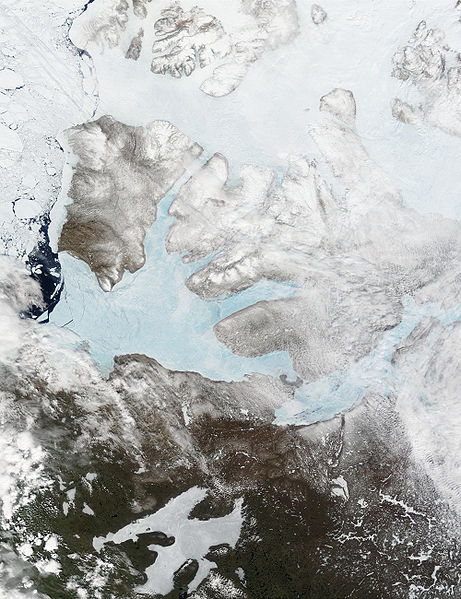
English: These Moderate resolution Imaging Spectroradiometer Images from June 14 and 16, 2002, show Banks Island (upper left) and Victoria Island (to the southeast) in the Arctic Ocean off northwest Canada. Left of center in each image is Amundsen Gulf, looking bright blue as this arm of the Beaufort Sea (at the southern end of the Arctic Ocean) begins to thaw. At the bottom of the images, the tundra of the Northwest Territories (left) and the Nunavut (right) Provinces of Canada is beginning to lose its winter snow cover. At bottom center of the portrait oriented image is Great Bear lake--still frozen. |
| Dyddiad | June 14 and 16, 2002 |
| Ffynhonnell | http://visibleearth.nasa.gov/view_rec.php?id=3342 |
| Awdur | Jacques Descloitres, MODIS Land Rapid Response Team, NASA/GSFC |
Trwyddedu
| This file is in the public domain in the United States because it was solely created by NASA. NASA copyright policy states that "NASA material is not protected by copyright unless noted". (See Template:PD-USGov, NASA copyright policy page or JPL Image Use Policy.) | ||
 |
Warnings:
|
Hanes y ffeil
Cliciwch ar ddyddiad / amser i weld y ffeil fel ag yr oedd bryd hynny.
| Dyddiad / Amser | Bawdlun | Hyd a lled | Defnyddiwr | Sylw | |
|---|---|---|---|---|---|
| cyfredol | 17:59, 20 Awst 2008 | | 4,000 × 5,200 (2.83 MB) | Ando228 | {{Information |Description={{en|1=These Moderate resolution Imaging Spectroradiometer Images from June 14 and 16, 2002, show Banks Island (upper left) and Victoria Island (to the southeast) in the Arctic Ocean off northwest Canada. Left of center in each |
Cysylltiadau'r ffeil
Mae'r 1 tudalennau a ddefnyddir isod yn cysylltu i'r ddelwedd hon:
Defnydd cydwici y ffeil
Mae'r wicis eraill hyn yn defnyddio'r ffeil hon:
- Y defnydd ar af.wikipedia.org
- Y defnydd ar ar.wikipedia.org
- Y defnydd ar ast.wikipedia.org
- Y defnydd ar az.wikipedia.org
- Y defnydd ar be.wikipedia.org
- Y defnydd ar bg.wikipedia.org
- Y defnydd ar bn.wikipedia.org
- Y defnydd ar ca.wikipedia.org
- Y defnydd ar ceb.wikipedia.org
- Y defnydd ar da.wikipedia.org
- Y defnydd ar de.wikivoyage.org
- Y defnydd ar diq.wikipedia.org
- Y defnydd ar en.wikipedia.org
- Y defnydd ar es.wikipedia.org
- Y defnydd ar eu.wikipedia.org
- Y defnydd ar fa.wikipedia.org
- Y defnydd ar fi.wikipedia.org
- Y defnydd ar fr.wikipedia.org
- Y defnydd ar fr.wikivoyage.org
- Y defnydd ar fy.wikipedia.org
- Y defnydd ar ga.wikipedia.org
- Y defnydd ar gl.wikipedia.org
- Y defnydd ar he.wikipedia.org
- Y defnydd ar hu.wikipedia.org
- Y defnydd ar hy.wikipedia.org
- Y defnydd ar ilo.wikipedia.org
- Y defnydd ar is.wikipedia.org
- Y defnydd ar it.wikipedia.org
- Y defnydd ar ja.wikipedia.org
- Y defnydd ar ko.wikipedia.org
- Y defnydd ar ku.wikipedia.org
- Y defnydd ar la.wikipedia.org
- Y defnydd ar lv.wikipedia.org
- Y defnydd ar ml.wikipedia.org
- Y defnydd ar mzn.wikipedia.org
- Y defnydd ar nl.wikipedia.org
- Y defnydd ar nn.wikipedia.org
- Y defnydd ar no.wikipedia.org
Gweld rhagor o'r defnydd cydwici o'r ffeil hon.