Delwedd:Capel Colman - geograph.org.uk - 572018.jpg
Maint y rhagolwg: 450 × 600 picsel. Eglurdebau eraill: 180 × 240 picsel | 480 × 640 picsel.
Maint llawn ((480 × 640 picsel, maint y ffeil: 98 KB, ffurf MIME: image/jpeg))
|
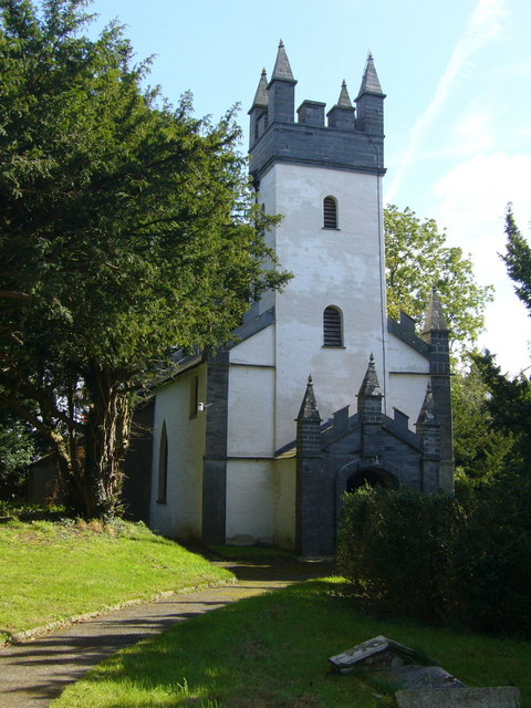
Dyma lun o adeilad rhestredig rhif 11971. |
Crynodeb
| Disgrifiad |
English: Capel Colman. To quote from a leaflet available at the chapel: "In 1764 Morgan Jones the Elder, master of the nearby Cilwendeg Estate, was responsible for completely rebuilding the long neglected medieval chapel called Capel Colman at the western perimeter of Cilwendeg Park - a church so remote and forgotten that in 1721 it was singled out as being fit 'only for the solitary habitations of Owles and Jackdaws'. Morgan Jones the Younger again rebuilt the church in 1833-5 to the designs of one of his estate tenants, Daniel Davies of Blaenpwllddu Farm."
This was essentially a private chapel for the estate, the local parish church was the 572000 less than a mile away. Today St. Michael's is in ruins and this chapel is still in use for regular worship. |
| Dyddiad | |
| Ffynhonnell | From geograph.org.uk |
| Awdur | Roger W Haworth |
| Cydnabyddiaeth (required by the license) | Roger W Haworth / Capel Colman / |
| Camera location | | View this and other nearby images on: OpenStreetMap |
|---|
_heading:112.00&language=cy)
| Object location | | View this and other nearby images on: OpenStreetMap |
|---|
_heading:112.00&language=cy)
Trwyddedu

|
This image was taken from the Geograph project collection. See this photograph's page on the Geograph website for the photographer's contact details. The copyright on this image is owned by Roger W Haworth and is licensed for reuse under the Creative Commons Attribution-ShareAlike 2.0 license.
|
Trwyddedir y ffeil hon yn ôl termau'r drwydded Creative Commons Attribution-Share Alike 2.0 Generic.
Cydnabyddiaeth: Roger W Haworth
- Mae'n rhydd i chi:
- rhannu – gallwch gopïo, dosbarthu a throsglwyddo'r gwaith
- ailwampio – gallwch addasu'r gwaith
- Ar yr amodau canlynol:
- cydnabyddiaeth – Mae'n rhaid i chi nodi manylion y gwaith hwn, rhoi dolen i'r drwydded, a nodi os y bu golygu arni, yn y modd a benwyd gan yr awdur neu'r trwyddedwr (ond heb awgrymu o gwbl eu bod yn eich cymeradwyo chi na'ch defnydd o'r gwaith).
- rhannu ar dermau tebyg – Os byddwch yn addasu'r gwaith hwn, neu yn ei drawsnewid, neu yn adeiladu arno, mae'n rhaid i chi ddosbarthu'r gwaith dan drwydded sy'n union yr un fath same a'r gwreiddiol.
Hanes y ffeil
Cliciwch ar ddyddiad / amser i weld y ffeil fel ag yr oedd bryd hynny.
| Dyddiad / Amser | Bawdlun | Hyd a lled | Defnyddiwr | Sylw | |
|---|---|---|---|---|---|
| cyfredol | 16:24, 25 Rhagfyr 2011 | | 480 × 640 (98 KB) | Rotatebot | Bot: Reset EXIF-specified Orientation of image (EXIF-Orientation set from 6 to 1, rotated 0°) |
| 09:37, 6 Chwefror 2011 |  | 640 × 480 (98 KB) | GeographBot | == {{int:filedesc}} == {{Information |description={{en|1=Capel Colman To quote from a leaflet available at the chapel: "In 1764 Morgan Jones the Elder, master of the nearby Cilwendeg Estate, was responsible for completely rebuilding the long neglected med |
Cysylltiadau'r ffeil
Mae'r 1 tudalennau a ddefnyddir isod yn cysylltu i'r ddelwedd hon:
Defnydd cydwici y ffeil
Mae'r wicis eraill hyn yn defnyddio'r ffeil hon:
- Y defnydd ar en.wikipedia.org
- Y defnydd ar www.wikidata.org