Delwedd:Cedid Atlas (Middle East) 1803.jpg

Maint y rhagolwg: 793 × 600 picsel. Eglurdebau eraill: 317 × 240 picsel | 635 × 480 picsel | 1,016 × 768 picsel | 1,280 × 968 picsel | 2,560 × 1,936 picsel | 10,840 × 8,199 picsel.
Maint llawn ((10,840 × 8,199 picsel, maint y ffeil: 18.62 MB, ffurf MIME: image/jpeg))
Crynodeb
| Warning | The original file is very high-resolution. It might not load properly or could cause your browser to freeze when opened at full size. |
|---|
| Disgrifiad |
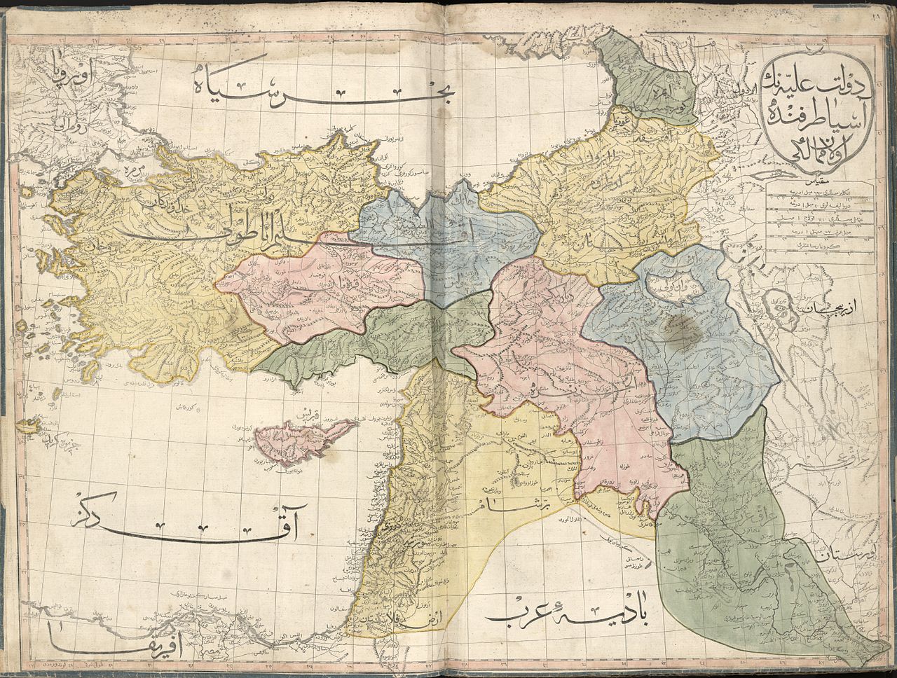
العربية: خارطة عُثمانيَّة تُظهر الإيالات الشرقيَّة لِلدولة العُثمانيَّة سنة 1803م. الخارطة مأخوذة من الأطلس الجديد (وهي واحدة من أصل 24 ورقة). هذا الأطلس هو أوَّل أطلسٍ جُغرافي يُطبع في العالم الإسلامي، ولم يُطبع منه سوى 50 نسخة، وبهذا فهو يُعتبر أحد أندر الأطالس الجُغرافيَّة ذات القيمة التاريخيَّة على المُستويين العالمي والشرق أوسطي.
English: The Middle East sheet of the 1803 Cedid Atlas (one of 24 sheets in total). It is the first published atlas in the Muslim world, and only 50 copies were printed at the press, as such it is one of the rarest printed atlases of historical value and of great importance to Middle Eastern history. |
||
| Dyddiad | |||
| Ffynhonnell |
|
||
| Crëwr |
Ottoman Empire |
||
| Georeferencing | If inappropriate please set warp_status = skip to hide. | ||
| Diwygiadau eraill |

_1803.jpg)

_1803.jpg)
|
_1803.jpg)
_1803.jpg)
Trwyddedu
This media file is in the public domain in the United States. This applies to U.S. works where the copyright has expired, often because its first publication occurred prior to January 1, 1929, and if not then due to lack of notice or renewal. See this page for further explanation.
|
 | |
 |
This image might not be in the public domain outside of the United States; this especially applies in the countries and areas that do not apply the rule of the shorter term for US works, such as Canada, Mainland China (not Hong Kong or Macao), Germany, Mexico, and Switzerland. The creator and year of publication are essential information and must be provided. See Wikipedia:Public domain and Wikipedia:Copyrights for more details.
|
Hanes y ffeil
Cliciwch ar ddyddiad / amser i weld y ffeil fel ag yr oedd bryd hynny.
| Dyddiad / Amser | Bawdlun | Hyd a lled | Defnyddiwr | Sylw | |
|---|---|---|---|---|---|
| cyfredol | 18:35, 9 Mai 2015 | | 10,840 × 8,199 (18.62 MB) | Onceinawhile | User created page with UploadWizard |
Cysylltiadau'r ffeil
Mae'r 1 tudalennau a ddefnyddir isod yn cysylltu i'r ddelwedd hon:
Defnydd cydwici y ffeil
Mae'r wicis eraill hyn yn defnyddio'r ffeil hon:
- Y defnydd ar ar.wikipedia.org
- العراق
- تاريخ العراق
- المسيحية في سوريا
- العراق العثماني
- بوابة:الدولة العثمانية/مقالة مختارة
- بوابة:الدولة العثمانية/صورة
- ويكيبيديا:صور مختارة/رسومات وجداول وخرائط/خرائط
- كردستان العراق
- ويكيبيديا:ترشيحات الصور المختارة/الإيالات العثمانية الشرقية
- ويكيبيديا:صورة اليوم المختارة/فبراير 2017
- قالب:صورة اليوم المختارة/2017-02-01
- بوابة:الدولة العثمانية/صورة مختارة/28
- قائمة إيالات الدولة العثمانية
- ويكيبيديا:قائمة اليوم المختارة/أغسطس 2017
- قالب:قائمة اليوم المختارة/2017-08-14
- بوابة:الدولة العثمانية/مقالة مختارة/36
- ويكيبيديا:قائمة اليوم المختارة/نوفمبر 2017
- قالب:قائمة اليوم المختارة/2017-11-18
- ويكيبيديا:قائمة اليوم المختارة/يناير 2018
- قالب:قائمة اليوم المختارة/2018-01-13
- ويكيبيديا:قائمة اليوم المختارة/يونيو 2018
- قالب:قائمة اليوم المختارة/2018-06-10
- ويكيبيديا:قائمة اليوم المختارة/أغسطس 2018
- قالب:قائمة اليوم المختارة/2018-08-04
- ويكيبيديا:قائمة اليوم المختارة/يناير 2019
- قالب:قائمة اليوم المختارة/2019-01-11
- ويكيبيديا:قائمة اليوم المختارة/يوليو 2019
- قالب:قائمة اليوم المختارة/2019-07-06
- ويكيبيديا:قائمة اليوم المختارة/ديسمبر 2019
- قالب:قائمة اليوم المختارة/2019-12-24
- ويكيبيديا:قائمة اليوم المختارة/يونيو 2020
- قالب:قائمة اليوم المختارة/2020-06-21
- ويكيبيديا:قائمة اليوم المختارة/سبتمبر 2020
- قالب:قائمة اليوم المختارة/2020-09-21
- ويكيبيديا:قائمة اليوم المختارة/أبريل 2021
- قالب:قائمة اليوم المختارة/2021-04-15
- ويكيبيديا:قائمة اليوم المختارة/أكتوبر 2021
- قالب:قائمة اليوم المختارة/2021-10-31
- ويكيبيديا:قائمة اليوم المختارة/يونيو 2022
- قالب:قائمة اليوم المختارة/2022-06-13
- ويكيبيديا:قائمة اليوم المختارة/يناير 2023
- قالب:قائمة اليوم المختارة/2023-01-31
- خرائط فلسطين
- ويكيبيديا:صورة اليوم المختارة/يوليو 2023
- قالب:صورة اليوم المختارة/2023-07-30
- ويكيبيديا:قائمة اليوم المختارة/سبتمبر 2023
- قالب:قائمة اليوم المختارة/2023-09-24
- Y defnydd ar arz.wikipedia.org
- Y defnydd ar bn.wikipedia.org
- Y defnydd ar ckb.wikipedia.org
Gweld rhagor o'r defnydd cydwici o'r ffeil hon.
_1803.jpg)
_1803.jpg)