Delwedd:China.A2002249.0255.250m.jpg

Maint y rhagolwg: 776 × 600 picsel. Eglurdebau eraill: 311 × 240 picsel | 621 × 480 picsel | 994 × 768 picsel | 1,280 × 989 picsel | 2,560 × 1,978 picsel | 4,400 × 3,400 picsel.
Maint llawn ((4,400 × 3,400 picsel, maint y ffeil: 2.14 MB, ffurf MIME: image/jpeg))
Crynodeb
http://visibleearth.nasa.gov/view_rec.php?id=4585 archive copy at the Wayback Machine
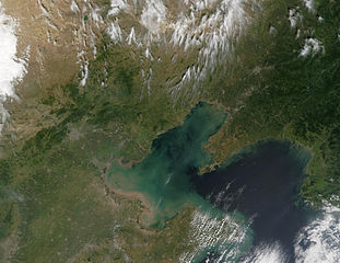
Northeast China (left), Southeast Russia (right) and North Korea (bottom left) put on a verdant display in the true-color Moderate Resolution Imaging Spectroradiometer (MODIS) from September 6, 2002. A few scattered fires were detected by MODIS and are marked with red dots.
Trwyddedu
| This file is in the public domain in the United States because it was solely created by NASA. NASA copyright policy states that "NASA material is not protected by copyright unless noted". (See Template:PD-USGov, NASA copyright policy page or JPL Image Use Policy.) | ||
 |
Warnings:
|
Hanes y ffeil
Cliciwch ar ddyddiad / amser i weld y ffeil fel ag yr oedd bryd hynny.
| Dyddiad / Amser | Bawdlun | Hyd a lled | Defnyddiwr | Sylw | |
|---|---|---|---|---|---|
| cyfredol | 14:41, 7 Hydref 2005 | | 4,400 × 3,400 (2.14 MB) | ChongDae | http://visibleearth.nasa.gov/view_rec.php?id=4585 Northeast China (left), Southeast Russia (right) and North Korea (bottom left) put on a verdant display in the true-color Moderate Resolution Imaging Spectroradiometer (MODIS) from September 6, 2002. A fe |
Cysylltiadau'r ffeil
Mae'r 1 tudalennau a ddefnyddir isod yn cysylltu i'r ddelwedd hon:
Defnydd cydwici y ffeil
Mae'r wicis eraill hyn yn defnyddio'r ffeil hon:
- Y defnydd ar ar.wikipedia.org
- Y defnydd ar ast.wikipedia.org
- Y defnydd ar be.wikipedia.org
- Y defnydd ar bg.wikipedia.org
- Y defnydd ar ca.wikipedia.org
- Y defnydd ar ceb.wikipedia.org
- Y defnydd ar cs.wikipedia.org
- Y defnydd ar de.wikivoyage.org
- Y defnydd ar eo.wikipedia.org
- Y defnydd ar es.wikipedia.org
- Y defnydd ar eu.wikipedia.org
- Y defnydd ar he.wikipedia.org
- Y defnydd ar hr.wikipedia.org
- Y defnydd ar ja.wikipedia.org
- Y defnydd ar ko.wikipedia.org
- Y defnydd ar mn.wikipedia.org
- Y defnydd ar mzn.wikipedia.org
- Y defnydd ar no.wikipedia.org
- Y defnydd ar pl.wikipedia.org
- Y defnydd ar pt.wikipedia.org
- Y defnydd ar ru.wikipedia.org
- Y defnydd ar sv.wikipedia.org
- Y defnydd ar www.wikidata.org
- Y defnydd ar zh-min-nan.wikipedia.org
- Y defnydd ar zh.wikipedia.org