Delwedd:Cocos(keeling) 76.jpg

Maint y rhagolwg: 519 × 600 picsel. Eglurdebau eraill: 208 × 240 picsel | 415 × 480 picsel | 885 × 1,023 picsel.
Maint llawn ((885 × 1,023 picsel, maint y ffeil: 141 KB, ffurf MIME: image/jpeg))
_76.jpg)
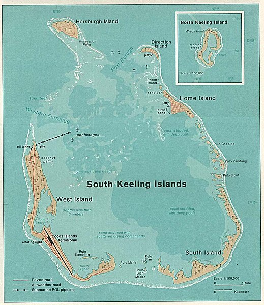
Crynodeb
| Disgrifiad |
Deutsch: Karte der Kokos(Keeling)-Inseln im Indischen Ozean
English: Map of Cocos (Keeling) Islands in the Indian Ocean |
| Dyddiad | |
| Ffynhonnell | http://www.lib.utexas.edu/maps/islands_oceans_poles/cocos(keeling)_76.jpg |
| Awdur | Taken from Perry-Castañeda Library (PCL), originally from CIA Indian Ocean Atlas |
_76.jpg)
Trwyddedu
| This image is a work of a Central Intelligence Agency employee, taken or made as part of that person's official duties. As a Work of the United States Government, this image or media is in the public domain in the United States.
|

|
Hanes y ffeil
Cliciwch ar ddyddiad / amser i weld y ffeil fel ag yr oedd bryd hynny.
| Dyddiad / Amser | Bawdlun | Hyd a lled | Defnyddiwr | Sylw | |
|---|---|---|---|---|---|
| cyfredol | 20:06, 5 Hydref 2006 | | 885 × 1,023 (141 KB) | Ratzer | http://www.lib.utexas.edu/maps/islands_oceans_poles/cocos(keeling)_76.jpg |
Cysylltiadau'r ffeil
Mae'r 1 tudalennau a ddefnyddir isod yn cysylltu i'r ddelwedd hon:
Defnydd cydwici y ffeil
Mae'r wicis eraill hyn yn defnyddio'r ffeil hon:
- Y defnydd ar ar.wikipedia.org
- Y defnydd ar ca.wikipedia.org
- Y defnydd ar ceb.wikipedia.org
- Y defnydd ar cs.wikipedia.org
- Y defnydd ar de.wikipedia.org
- Y defnydd ar el.wikipedia.org
- Y defnydd ar en.wikipedia.org
- Y defnydd ar en.wikivoyage.org
- Y defnydd ar eo.wikipedia.org
- Y defnydd ar es.wikipedia.org
- Y defnydd ar et.wikipedia.org
- Y defnydd ar eu.wikipedia.org
- Y defnydd ar fa.wikipedia.org
- Y defnydd ar fi.wikipedia.org
- Y defnydd ar fr.wikipedia.org
- Y defnydd ar he.wikipedia.org
- Y defnydd ar hr.wikipedia.org
- Y defnydd ar id.wikipedia.org
- Y defnydd ar it.wikipedia.org
- Y defnydd ar ja.wikipedia.org
- Y defnydd ar ko.wikipedia.org
- Y defnydd ar lt.wikipedia.org
- Y defnydd ar ms.wikipedia.org
- Y defnydd ar ms.wiktionary.org
- Y defnydd ar nl.wikipedia.org
- Y defnydd ar no.wikipedia.org
- Y defnydd ar pl.wikipedia.org
- Y defnydd ar ps.wikipedia.org
Gweld rhagor o'r defnydd cydwici o'r ffeil hon.
_76.jpg)
_76.jpg)