Delwedd:Crags on summit of Mynydd Graig Goch - geograph.org.uk - 196667.jpg
Wedi ei chwyddo hyd yr eithaf.
Crags_on_summit_of_Mynydd_Graig_Goch_-_geograph.org.uk_-_196667.jpg ((640 × 480 picsel, maint y ffeil: 138 KB, ffurf MIME: image/jpeg))
Crynodeb
| Disgrifiad |
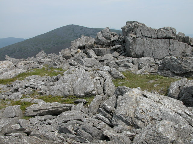
English: Crags on summit of Mynydd Graig Goch. Mynydd Graig Goch is situated at the western end of the Nantlle Ridge, though many walkers do not venture beyond Garnedd-goch which can be seen in the background. The summit of Snowdon is just visible between the rocky crags.
In September 2008, this summit made national news after three walkers surveyed it after suspecting it was really just over 2000 feet and therefore officially classified as a mountain. Their survey has been recognised by Ordnance Survey thus bringing the total of mountains in Wales to 190. Maybe now it has been elevated to mountain status it will attract more walkers to its rocky summit. See: https://www.telegraph.co.uk/news/newstopics/politics/wales/2989936/Wales-acquires-a-new-mountain-but-loses-a-hill.html |
| Dyddiad | |
| Ffynhonnell | From geograph.org.uk |
| Awdur | Philip Halling |
| Cydnabyddiaeth (required by the license) | Philip Halling / Crags on summit of Mynydd Graig Goch / |
| Camera location | | View this and other nearby images on: OpenStreetMap |
|---|
_heading:45.00&language=cy)
| Object location | | View this and other nearby images on: OpenStreetMap |
|---|
_heading:45.00&language=cy)
Trwyddedu

|
This image was taken from the Geograph project collection. See this photograph's page on the Geograph website for the photographer's contact details. The copyright on this image is owned by Philip Halling and is licensed for reuse under the Creative Commons Attribution-ShareAlike 2.0 license.
|
Trwyddedir y ffeil hon yn ôl termau'r drwydded Creative Commons Attribution-Share Alike 2.0 Generic.
Cydnabyddiaeth: Philip Halling
- Mae'n rhydd i chi:
- rhannu – gallwch gopïo, dosbarthu a throsglwyddo'r gwaith
- ailwampio – gallwch addasu'r gwaith
- Ar yr amodau canlynol:
- cydnabyddiaeth – Mae'n rhaid i chi nodi manylion y gwaith hwn, rhoi dolen i'r drwydded, a nodi os y bu golygu arni, yn y modd a benwyd gan yr awdur neu'r trwyddedwr (ond heb awgrymu o gwbl eu bod yn eich cymeradwyo chi na'ch defnydd o'r gwaith).
- rhannu ar dermau tebyg – Os byddwch yn addasu'r gwaith hwn, neu yn ei drawsnewid, neu yn adeiladu arno, mae'n rhaid i chi ddosbarthu'r gwaith dan drwydded sy'n union yr un fath same a'r gwreiddiol.
Hanes y ffeil
Cliciwch ar ddyddiad / amser i weld y ffeil fel ag yr oedd bryd hynny.
| Dyddiad / Amser | Bawdlun | Hyd a lled | Defnyddiwr | Sylw | |
|---|---|---|---|---|---|
| cyfredol | 15:38, 31 Ionawr 2010 | | 640 × 480 (138 KB) | GeographBot | == {{int:filedesc}} == {{Information |description={{en|1=Crags on summit of Mynydd Graig Goch. Mynydd Graig Goch is situated at the western end of the Nantlle Ridge, though many walkers do not venture beyond Garnedd-goch which can be seen in the backgroun |
Cysylltiadau'r ffeil
Mae'r 1 tudalennau a ddefnyddir isod yn cysylltu i'r ddelwedd hon:
Defnydd cydwici y ffeil
Mae'r wicis eraill hyn yn defnyddio'r ffeil hon:
- Y defnydd ar arz.wikipedia.org
- Y defnydd ar ceb.wikipedia.org
- Y defnydd ar en.wikipedia.org
- Y defnydd ar lld.wikipedia.org
- Y defnydd ar sv.wikipedia.org
- Y defnydd ar www.wikidata.org