Delwedd:Earth-cutaway-schematic-numbered.svg

Maint rhagolwg PNG o ffeil SVG yw: 612 × 599 picsel. Eglurdebau eraill: 245 × 240 picsel | 490 × 480 picsel | 785 × 768 picsel | 1,046 × 1,024 picsel | 2,092 × 2,048 picsel | 950 × 930 picsel.
Maint llawn (Ffeil SVG, maint mewn enw 950 × 930 picsel, maint y ffeil: 93 KB)
| Disgrifiad |
English: Language neutral version of File:Earth-cutaway-schematic-english.svg
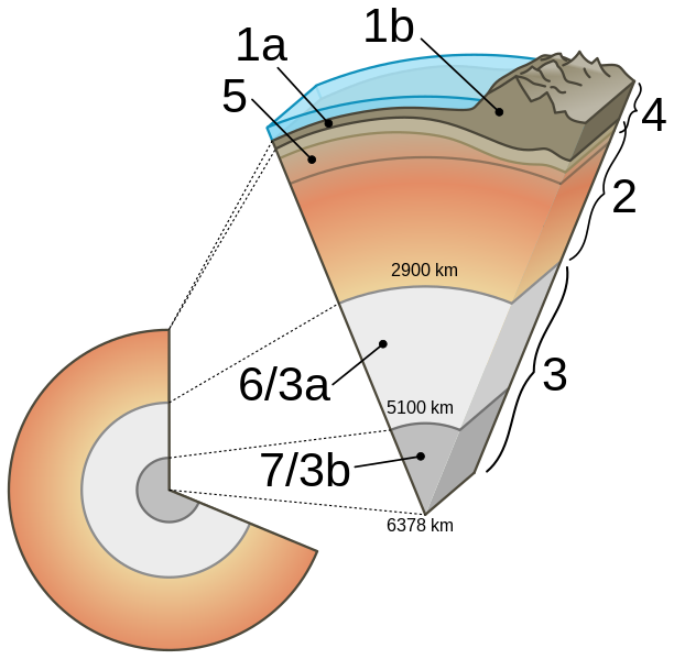
Cutaway diagram of Earth's internal structure (to scale) with inset showing detailed breakdown of structure (not to scale). Label: 1: Crust (oceanic /1a/ and continental /1b/ crust 0 to 80 km); 2: Mantle (upper mantle, including asthenosphere, and lower mantle); 3: Core; 3a: Outer core (liquid); 3b: Inner core (solid); 4: Lithosphere (Crust and uppermost solid mantle); 5: Asthenosphere |
| Dyddiad | (UTC) |
| Ffynhonnell |
|
| Awdur |
Original: USGS Vector: |
| Diwygiadau eraill |
[]
PNG:
|
| SVG genesis | This W3C-invalid diagram was created with Inkscape. This diagram uses embedded text that can be easily translated using a text editor. |


.svg)
-fr.svg)


Yr wyf fi, deiliad yr hawlfraint ar y gwaith hwn, yn ei gyhoeddi yn ôl termau'r drwydded a ganlyn:
| Yr wyf fi, deiliad hawlfraint y gwaith hwn, yn ei ryddhau i'r parth cyhoeddus, a hynny'n fyd-eang. Hwyrach nad yw hyn yn bosib yn ôl cyfraith rhai gwledydd; os felly: Rwyn rhoi i unrhywun yr hawl i ddefnyddio'r gwaith hwn at unrhyw ddiben, heb unrhyw amodau, oddieithr unrhyw amodau gofynnol yn ôl y gyfraith. |
Hanes y ffeil
Cliciwch ar ddyddiad / amser i weld y ffeil fel ag yr oedd bryd hynny.
| Dyddiad / Amser | Bawdlun | Hyd a lled | Defnyddiwr | Sylw | |
|---|---|---|---|---|---|
| cyfredol | 22:32, 20 Awst 2020 | | 950 × 930 (93 KB) | Nefronus | putting back the twofold labeling, separating astenosphere (by the way, asthenosphere was number 5, 2 was the mantle including the lithospheric part – as in the original, no problem in that) |
| 15:41, 12 Tachwedd 2019 |  | 1,280 × 900 (51 KB) | Gretarsson | Reverted to version as of 00:41, 29 April 2013 (UTC): wrong labelling: 2 was _not_ the Asthenospere in its entirety but the whole sublithospheric mantle! An when overwriting an existing file, make sure that there is no adjustment of the captions in the Wikipedias or elswhere necessary (i.e. the labelling should be identical in old and new versions) | |
| 12:00, 2 Awst 2019 |  | 950 × 930 (73 KB) | Nefronus | right crop | |
| 11:30, 2 Awst 2019 |  | 1,023 × 930 (73 KB) | Nefronus | less aggresive colors so people don't think the mantle is magma | |
| 12:11, 1 Awst 2019 |  | 950 × 930 (77 KB) | Nefronus | polished drawing; 1a and 1b for oceanic/continental crust; 6/7 abandoned (unnecessary duplicate) | |
| 00:41, 29 Ebrill 2013 |  | 1,280 × 900 (51 KB) | Anasofiapaixao | {{Information |Description={{en|1=Language neutral version of Earth-cutaway-schematic-english.svg Cutaway diagram of Earth's internal structure (to scale) with inset showing detailed breakdown of structure ... |
Cysylltiadau'r ffeil
Mae'r 1 tudalennau a ddefnyddir isod yn cysylltu i'r ddelwedd hon:
Defnydd cydwici y ffeil
Mae'r wicis eraill hyn yn defnyddio'r ffeil hon:
- Y defnydd ar ar.wikipedia.org
- Y defnydd ar ca.wikipedia.org
- Y defnydd ar de.wikipedia.org
- Y defnydd ar en.wikipedia.org
- Y defnydd ar en.wikibooks.org
- Y defnydd ar eo.wikipedia.org
- Y defnydd ar eu.wikipedia.org
- Y defnydd ar fr.wikibooks.org
- Y defnydd ar fr.wikiversity.org
- Y defnydd ar gl.wikipedia.org
- Y defnydd ar he.wikipedia.org
- Y defnydd ar hy.wikipedia.org
- Y defnydd ar id.wikipedia.org
- Y defnydd ar it.wikipedia.org
- Y defnydd ar it.wikibooks.org
- Y defnydd ar ja.wikipedia.org
- Y defnydd ar ja.wikibooks.org
- Y defnydd ar ko.wikipedia.org
- Y defnydd ar ky.wikipedia.org
- Y defnydd ar la.wikipedia.org
Gweld rhagor o'r defnydd cydwici o'r ffeil hon.