Delwedd:Eden Project geodesic domes panorama.jpg
Maint llawn ((3,700 × 1,155 picsel, maint y ffeil: 3.77 MB, ffurf MIME: image/jpeg))
|

Crynodeb
| Disgrifiad |
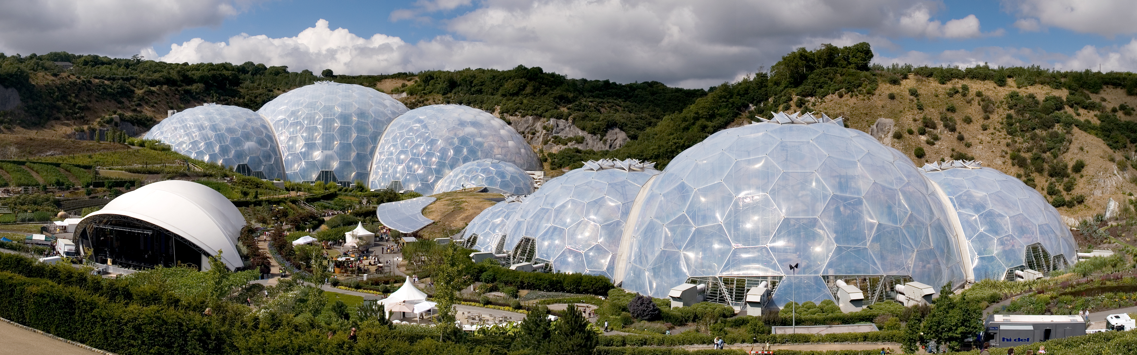
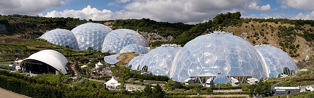
English: Panoramic view of the geodesic dome structures of the Eden Project. The Eden Project is a large-scale environmental complex near St Austell, Cornwall, England, United Kingdom. The project was conceived by Tim Smit and has quickly become one of the most popular visitor attractions in the United Kingdom. The complex includes two giant, transparent domes made of ETFE cushions, each emulating a natural biome, that house plant species from around the world. The first emulates a tropical environment, the other a warm temperate, mediterranean environment. The project took 2½ years to construct and opened to the public in March 2001. Français : Vue panoramique des structures en dômes géodésiques de l'Eden Project. Eden Project est un complexe à grande échelle près de St Austell, dans les Cornouailles (Royaume-Uni). Ce projet a été concu par Tim Smit et est rapidement devenue l'une des attraction les plus visitées du Royaume-Uni. Le complexe comprend deux dômes transparents constitués de bulles d'ETFE. Chacun simule un biome, et contient de nombreuses espèces végétales venant du monde entier. La première simule un environnement tropical, l'autre un environnement tempéré doux, de type méditerranéen. Ce projet a nécessité 2,5 années pour sa construction et a ouvert au public en mars 2001. Deutsch: Panoramaansicht über die geodätischen Kuppeln des Eden Projects. Das Eden Project ist ein noch junger botanischer Garten bei Bodelva in Cornwall, England, etwa 5 Meilen nordöstlich von St. Austell. Die gesamte Anlage ist ca. 50 Hektar groß. Kernowek: Vu a-derdro a'n krommdohow a'n Edenva. An Edenva yw splatt bras kerghynnedh ogas Austol, Kernow, Pow Sows, Ruwvaneth Unys. An ragdres a veu koncevys gans Tim Smit hag ev re veu unn a'n moyha vysytys tennvosow y'n Ruwvaneth Unys. An splatt a komprehend diw krommtohow kowrek gwrys a pluvogow ETFE. Unn a wra war-legh kerghynnedh tropek hag an aral kerghynnedh tomm kresvorek. An ragdres a wrug kemeres diw ha hanter bledhynnyow drehevel hag ev a veu ygerys a'n poblek yn mis Meurth 2001. |
| Dyddiad | |
| Ffynhonnell | own work (JMatern_060812_1822-1828_WP.jpg) |
| Awdur | Jürgen Matern |
| Caniatâd (Ailddefnyddio'r ffeil hon) |
Jürgen Matern released it under CC-BY-SA |
| Camera location | | View this and other nearby images on: OpenStreetMap |
|---|
Deutsch: Dieses Werk wurde von Jürgen Matern erstellt.
Sie können diese Aufnahme weiterverwenden, so lange Sie mich als Urheber nennen. Beispiel: Falls Sie dieses Bild außerhalb des Wikimedia-Projektes benutzen, würde ich mich freuen von Ihnen zu hören. Möglicherweise habe ich weitere Aufnahmen zum gleichen Objekt/ Thema. Falls Sie die Aufnahme in höherer Auflösung wünschen, so können Sie mich ebenfalls kontaktieren.English: This work was created by Jürgen Matern.
You are free to use it for any purpose as long as you credit me properly. Example: If you use this image outside of Wikimedia projects, I would be happy to hear from you. I may also have more pictures about the same subject/ theme. If you would like to have the picture in a higher resolution, you can also contact me. |

|
NOTE: This image is a panorama consisting of multiple frames that were merged or stitched in software. As a result, this image necessarily underwent some form of digital manipulation. These manipulations may include blending, blurring, cloning, and colour and perspective adjustments. As a result of these adjustments, the image content may be slightly different from reality at the points where multiple images were combined. This manipulation is often required due to lens, perspective, and parallax distortions.
|
| This is a retouched picture, which means that it has been digitally altered from its original version. Modifications: English: This image is a panorama which was stitched from 7 images. Projection is cylindrical. Horizontal field of view is approx. 105°. Deutsch: Dieses Bild ist ein Panorama, welches aus 7 Einzelaufnahmen zusammengesetzt wurde. Die verwendete Projektion ist zylindrisch. Der horizontale Bildwinkel is ca. 105°. .
|
Trwyddedu
- Mae'n rhydd i chi:
- rhannu – gallwch gopïo, dosbarthu a throsglwyddo'r gwaith
- ailwampio – gallwch addasu'r gwaith
- Ar yr amodau canlynol:
- cydnabyddiaeth – Mae'n rhaid i chi nodi manylion y gwaith hwn, rhoi dolen i'r drwydded, a nodi os y bu golygu arni, yn y modd a benwyd gan yr awdur neu'r trwyddedwr (ond heb awgrymu o gwbl eu bod yn eich cymeradwyo chi na'ch defnydd o'r gwaith).
- rhannu ar dermau tebyg – Os byddwch yn addasu'r gwaith hwn, neu yn ei drawsnewid, neu yn adeiladu arno, mae'n rhaid i chi ddosbarthu'r gwaith dan drwydded sy'n union yr un fath same a'r gwreiddiol.
Hanes y ffeil
Cliciwch ar ddyddiad / amser i weld y ffeil fel ag yr oedd bryd hynny.
| Dyddiad / Amser | Bawdlun | Hyd a lled | Defnyddiwr | Sylw | |
|---|---|---|---|---|---|
| cyfredol | 20:30, 30 Awst 2006 | 3,700 × 1,155 (3.77 MB) | JürgenMatern | {{Information |Description=Panoramic view of the geodesic dome structures of Eden Project |Source=own work (JMatern_060812_1822-1828_WP.jpg) |Date=2006-08-12 |Author=Jürgen Matern |Permission=Jürgen Matern r |
Cysylltiadau'r ffeil
Mae'r 1 tudalennau a ddefnyddir isod yn cysylltu i'r ddelwedd hon:
Defnydd cydwici y ffeil
Mae'r wicis eraill hyn yn defnyddio'r ffeil hon:
- Y defnydd ar af.wikipedia.org
- Y defnydd ar ar.wikipedia.org
- Y defnydd ar azb.wikipedia.org
- Y defnydd ar bg.wikipedia.org
- Y defnydd ar ca.wikipedia.org
- Y defnydd ar cs.wikipedia.org
- Y defnydd ar de.wikipedia.org
- James Bond 007 – Stirb an einem anderen Tag
- Blob-Architektur
- Portal:Architektur und Bauwesen/titelbild/archiv
- Portal:Architektur und Bauwesen/Ausgezeichnete Darstellungen
- Wikipedia:Exzellente Bilder/Kunst und Kultur
- Wikipedia:Kandidaten für exzellente Bilder/Archiv2009/6
- Datei:Eden Project geodesic domes panorama.jpg
- Kuppelgewächshaus
- Y defnydd ar de.wikivoyage.org
- Y defnydd ar en.wikipedia.org
- Talk:Buckminster Fuller
- Eden Project
- Dome
- St Austell
- Technogaianism
- Blobitecture
- Wikipedia:WikiProject UK geography
- St Blazey
- Wikipedia:Featured pictures thumbs/06
- Wikipedia:Featured pictures/Places/Panorama
- Wikipedia:WikiProject Cornwall
- Vector Foiltec
- Portal:United Kingdom/Featured picture
- Wikipedia:Featured picture candidates/April-2007
- Wikipedia:Wikipedia Signpost/2007-04-16/Features and admins
- Wikipedia:Featured picture candidates/Eden Project geodesic domes panorama.jpg
- Bionic architecture
- Portal:United Kingdom/Featured picture/31
- Wikipedia:Wikipedia Signpost/2007-04-16/SPV
- Wikipedia:Picture of the day/August 2007
- Template:POTD/2007-08-05
- User talk:Childzy/1
- Portal:Europe/Selected panorama
- Portal:Europe/Selected panorama/12
- User:Scriberius/Babelmania
- Grimshaw Architects
- User:Doug Weller/Bedson
- Andrew Whalley
- User:AmateurEditor/dome
- Michael Pawlyn
- Wikipedia:Wikipedia Signpost/Single/2007-04-16
- Y defnydd ar en.wikinews.org
- Y defnydd ar en.wikivoyage.org
Gweld rhagor o'r defnydd cydwici o'r ffeil hon.