Delwedd:Everglades ecoregion.jpg
Wedi ei chwyddo hyd yr eithaf.
Everglades_ecoregion.jpg ((400 × 443 picsel, maint y ffeil: 145 KB, ffurf MIME: image/jpeg))
Crynodeb
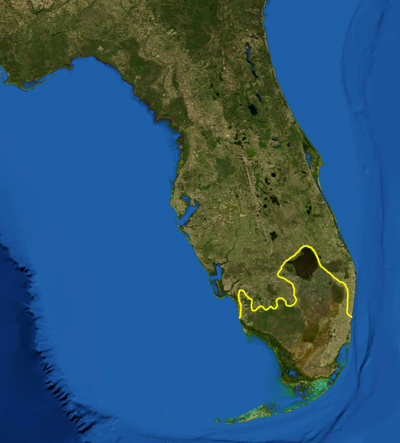
| Disgrifiad | This is a map showing the location of the Everglades. The yellow line encloses ecoregions as delineated by the World Wide Fund for Nature: the "Everglades" (NT0904) and the "South Florida rocklands" (NT0164). I, Pfly, made it using NASA Blue Marble imagery and ecoregion GIS data which I simplified and digitized in Photoshop. |
| Dyddiad | |
| Ffynhonnell | NASA, plus my additions by myself. |
| Awdur | Pfly |
Trwyddedu
| This file is in the public domain in the United States because it was solely created by NASA. NASA copyright policy states that "NASA material is not protected by copyright unless noted". (See Template:PD-USGov, NASA copyright policy page or JPL Image Use Policy.) | ||
 |
Warnings:
|
Hanes y ffeil
Cliciwch ar ddyddiad / amser i weld y ffeil fel ag yr oedd bryd hynny.
| Dyddiad / Amser | Bawdlun | Hyd a lled | Defnyddiwr | Sylw | |
|---|---|---|---|---|---|
| cyfredol | 14:50, 10 Mai 2012 | | 400 × 443 (145 KB) | Skobayas | Reverted to version as of 09:59, 11 March 2007 |
| 14:48, 10 Mai 2012 |  | 400 × 443 (79 KB) | Skobayas | Added the city of Naples | |
| 09:59, 11 Mawrth 2007 |  | 400 × 443 (145 KB) | Pfly | {{Information |Description=This is a map showing the location of the Everglades. The yellow line encloses ecoregions as delineated by the World Wide Fund for Nature: the "Everglades" (NT0904) and the " |
Cysylltiadau'r ffeil
Mae'r 1 tudalennau a ddefnyddir isod yn cysylltu i'r ddelwedd hon:
Defnydd cydwici y ffeil
Mae'r wicis eraill hyn yn defnyddio'r ffeil hon:
- Y defnydd ar ca.wikipedia.org
- Y defnydd ar en.wikipedia.org
- Y defnydd ar eo.wikipedia.org
- Y defnydd ar es.wikipedia.org
- Y defnydd ar gl.wikipedia.org
- Y defnydd ar it.wikipedia.org
- Y defnydd ar nl.wikipedia.org
- Y defnydd ar nn.wikipedia.org
- Y defnydd ar pt.wikipedia.org
- Y defnydd ar ro.wikipedia.org
- Y defnydd ar sr.wikipedia.org
- Y defnydd ar sw.wikipedia.org
- Y defnydd ar tr.wikipedia.org
- Y defnydd ar uk.wikipedia.org