Delwedd:First century Iudaea province.gif
Maint llawn((575 × 792 picsel, maint y ffeil: 31 KB, ffurf MIME: image/gif))

Daw'r ffeil hon o Comin Wikimedia a gellir ei defnyddio gan brosiectau eraill. Dangosir isod y disgrifiad sydd ar dudalen ddisgrifio'r ffeil yno.

This map image could be re-created using vector graphics as an SVG file. This has several advantages; see Commons:Media for cleanup for more information. If an SVG form of this image is available, please upload it and afterwards replace this template with {{vector version available|new image name}}.


It is recommended to name the SVG file “First century Iudaea province.svg”—then the template Vector version available (or Vva) does not need the new image name parameter.

Crynodeb

Disgrifiad
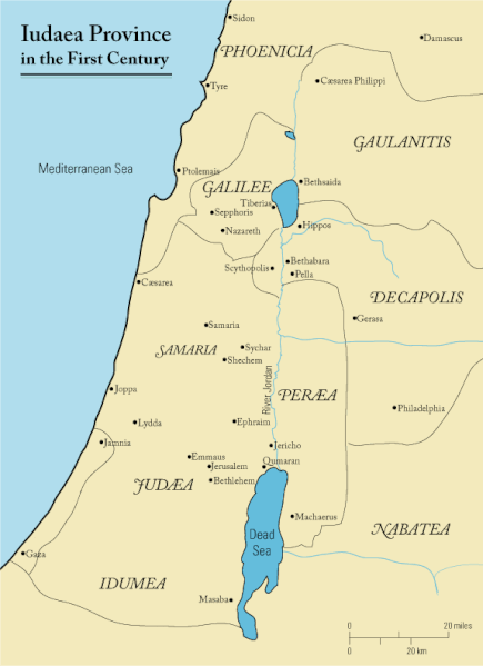
English: This is a map of first century Iudaea Province that I created using Illustrator CS2. I traced this image for the general geographic features. I then manually input data from maps found in a couple of sources.
  • Robert W. Funk and the Jesus Seminar. The Acts of Jesus. HarperSanFrancisco: 1998. p. xxiv.
  • Michael Grant. Jesus: An Historian's Review of the Gospels. Charles Scribner's Sons: 1977. p. 65-67.
  • John P. Meier. A Marginal Jew. Doubleday: 1991. p. 1:434.
Dyddiad 23 Mawrth 2006 (original upload date)
Ffynhonnell Transferred from en.wikipedia to Commons.
Awdur Andrew c at Saesneg Wicipedia
Caniatâd
(Ailddefnyddio'r ffeil hon)
Released under the GNU Free Documentation License or CC-BY.
Diwygiadau eraill العربيَّة

Trwyddedu

Mae Andrew c from en.wikipedia.org, deiliad yr hawlfraint ar y gwaith hwn, yn ei gyhoeddi yn ôl termau'r drwydded a ganlyn:
GNU head Caniateir copïo, dosbarthu a/neu golygu'r ddogfen hon yn ôl telerau'r Drwydded Ddogfennaeth Rydd GNU, Fersiwn 1.2 neu unrhyw fersiwn diweddarach a gyhoeddwyd gan y Free Software Foundation; yn cynnwys dim Adrannau Di-syfl, dim Testunau Clawr Blaen, a dim Testunau Clawr Cefn. Cynhwysir copi o'r drwydded hon yn yr adran Trwydded Ddogfennaeth Rydd GNU". Subject to disclaimers.
w:en:Creative Commons
cydnabyddiaeth
Trwyddedir y ffeil hon yn ôl termau'r drwydded Creative Commons Attribution 3.0 Unported.
Cydnabyddiaeth: Wikipedia User:Andrew c
Mae'n rhydd i chi:
  • rhannu – gallwch gopïo, dosbarthu a throsglwyddo'r gwaith
  • ailwampio – gallwch addasu'r gwaith
Ar yr amodau canlynol:
  • cydnabyddiaeth – Mae'n rhaid i chi nodi manylion y gwaith hwn, rhoi dolen i'r drwydded, a nodi os y bu golygu arni, yn y modd a benwyd gan yr awdur neu'r trwyddedwr (ond heb awgrymu o gwbl eu bod yn eich cymeradwyo chi na'ch defnydd o'r gwaith).
Public domain Yr wyf fi, deiliad hawlfraint y gwaith hwn, yn ei ryddhau i'r parth cyhoeddus, a hynny'n fyd-eang.
Hwyrach nad yw hyn yn bosib yn ôl cyfraith rhai gwledydd; os felly:
Rwyn rhoi i unrhywun yr hawl i ddefnyddio'r gwaith hwn at unrhyw ddiben, heb unrhyw amodau, oddieithr unrhyw amodau gofynnol yn ôl y gyfraith.

Cofnod lòg yr uwchlwythiad gwreiddiol

The original description page was here. All following user names refer to en.wikipedia.
  • 2006-03-24 18:48 Andrew c 575×792×8 (32374 bytes) This is a map of First Century Palestine that I created using Illustrator CS2. I traced [http://commons.wikimedia.org/wiki/Image:Map_of_administrative_regions_in_Israel.png this] image for the general geographic features. I then manually input data from m
  • 2006-03-23 19:48 Andrew c 587×790×8 (30752 bytes) This is a map of First Century Palestine that I created using Illustrator CS2. I traced [http://commons.wikimedia.org/wiki/Image:Map_of_administrative_regions_in_Israel.png this] image for the general geographic features. I then manually input data from m

Captions

Add a one-line explanation of what this file represents
Judaea province in the 1st Century CE

Items portrayed in this file

yn portreadu

23 Mawrth 2006

media type Saesneg

image/gif

checksum Saesneg

e488e0183049d2138c916ccc7a24c107807f12b7

data size Saesneg

32,019 byte

792 pixel

575 pixel

Hanes y ffeil

Cliciwch ar ddyddiad / amser i weld y ffeil fel ag yr oedd bryd hynny.

Dyddiad / AmserBawdlunHyd a lledDefnyddiwrSylw
cyfredol11:47, 18 Medi 2011Bawdlun y fersiwn am 11:47, 18 Medi 2011575 × 792 (31 KB)OnceinawhileRemoved region-name "Philistia", as incorrect
14:05, 13 Medi 2007Bawdlun y fersiwn am 14:05, 13 Medi 2007575 × 792 (32 KB)Liftarn{{SVG|map}} {{Information |Description=This is a map of first century en:Iudaea Province that I created using Illustrator CS2. I traced [http://commons.wikimedia.org/wiki/Image:Map_of_administrative_regions_in_Israel.png this] image for the general g
00:29, 30 Ebrill 2006Bawdlun y fersiwn am 00:29, 30 Ebrill 2006575 × 792 (32 KB)Duende~commonswikihttp://en.wikipedia.org/wiki/Image:First_century_palestine.gif

Mae'r 2 tudalennau a ddefnyddir isod yn cysylltu i'r ddelwedd hon:

Defnydd cydwici y ffeil

Mae'r wicis eraill hyn yn defnyddio'r ffeil hon:

Gweld rhagor o'r defnydd cydwici o'r ffeil hon.