Delwedd:Fort Union.jpg
Wedi ei chwyddo hyd yr eithaf.
Fort_Union.jpg ((600 × 346 picsel, maint y ffeil: 25 KB, ffurf MIME: image/jpeg))
Crynodeb
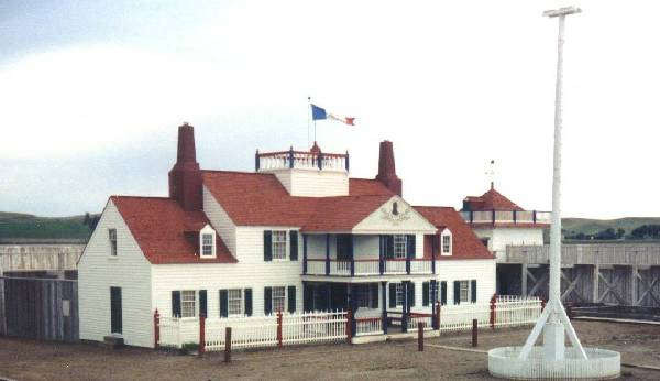
| Disgrifiad | Picture of Fort Union Trading Post National Historic Site on the North Dakota / Montana Border |
| Dyddiad | |
| Ffynhonnell | http://nd.water.usgs.gov/lewisandclark/photos10.html |
| Awdur | U.S. Geological Society |
| Object location | | View this and other nearby images on: OpenStreetMap |
|---|
Trwyddedu
This image is in the public domain in the United States because it only contains materials that originally came from the United States Geological Survey, an agency of the United States Department of the Interior. For more information, see the official USGS copyright policy.
|
Hanes y ffeil
Cliciwch ar ddyddiad / amser i weld y ffeil fel ag yr oedd bryd hynny.
| Dyddiad / Amser | Bawdlun | Hyd a lled | Defnyddiwr | Sylw | |
|---|---|---|---|---|---|
| cyfredol | 16:18, 17 Tachwedd 2007 | | 600 × 346 (25 KB) | Spudboy~commonswiki | {{Information |Description=Picture of Fort Union Trading Post National Historic Site on the North Dakota / Montana Border |Source=http://nd.water.usgs.gov/lewisandclark/photos10.html |Date=June 1992 |Author=U.S. Geological Society |Permission= |other_vers |
Cysylltiadau'r ffeil
Mae'r 1 tudalennau a ddefnyddir isod yn cysylltu i'r ddelwedd hon:
Defnydd cydwici y ffeil
Mae'r wicis eraill hyn yn defnyddio'r ffeil hon:
- Y defnydd ar ar.wikipedia.org
- Y defnydd ar ca.wikipedia.org
- Y defnydd ar ceb.wikipedia.org
- Y defnydd ar de.wikipedia.org
- Y defnydd ar en.wikipedia.org
- Y defnydd ar es.wikipedia.org
- Y defnydd ar fr.wikipedia.org
- Y defnydd ar ga.wikipedia.org
- Y defnydd ar hu.wikipedia.org
- Y defnydd ar it.wikipedia.org
- Y defnydd ar ja.wikipedia.org
- Y defnydd ar ko.wikipedia.org
- Y defnydd ar no.wikipedia.org
- Y defnydd ar pl.wikipedia.org
- Y defnydd ar pt.wikipedia.org
- Y defnydd ar ru.wikipedia.org
- Y defnydd ar sr.wikipedia.org
- Y defnydd ar sv.wikipedia.org
- Y defnydd ar tr.wikipedia.org
- Y defnydd ar tt.wikipedia.org
- Y defnydd ar www.wikidata.org