Delwedd:Germany Morgenthau Plan-en.svg

Maint rhagolwg PNG o ffeil SVG yw: 666 × 599 picsel. Eglurdebau eraill: 267 × 240 picsel | 533 × 480 picsel | 853 × 768 picsel | 1,138 × 1,024 picsel | 2,276 × 2,048 picsel | 1,000 × 900 picsel.
Maint llawn (Ffeil SVG, maint mewn enw 1,000 × 900 picsel, maint y ffeil: 129 KB)
Crynodeb
| Disgrifiad |
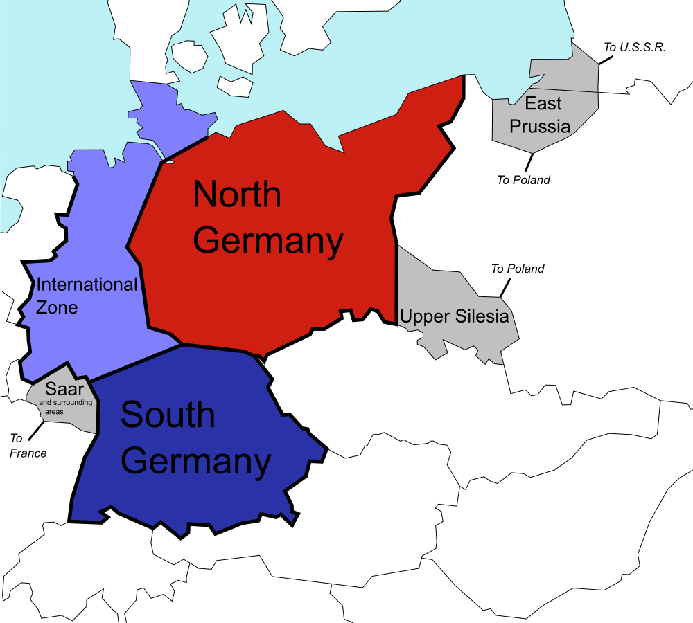
English: The (1944) U.S. "Morgenthau Plan" showing the planned partitioning of Germany into a North State, a South State, and an International zone. Areas in grey are areas intended for annexation by France, Poland and the U.S.S.R. |
| Dyddiad | |
| Ffynhonnell |
This file was derived from: Germany Morgenthau Plan.png: |
| Awdur |
Original: Vector: |
| SVG genesis |
Trwyddedu
| Yr wyf fi, deiliad hawlfraint y gwaith hwn, yn ei ryddhau i'r parth cyhoeddus, a hynny'n fyd-eang. Hwyrach nad yw hyn yn bosib yn ôl cyfraith rhai gwledydd; os felly: Rwyn rhoi i unrhywun yr hawl i ddefnyddio'r gwaith hwn at unrhyw ddiben, heb unrhyw amodau, oddieithr unrhyw amodau gofynnol yn ôl y gyfraith. |
Cofnod lòg yr uwchlwythiad gwreiddiol
This image is a derivative work of the following images:
- File:Germany Morgenthau Plan.png licensed with Cc-by-sa-3.0-migrated, GFDL, PD-self
- 2006-07-06T08:40:57Z Stor stark7 998x896 (149331 Bytes) The (1944) "Morgenthau Plan" map showing the planned partitioning of Germany into a North State, a South State, and an International zone. Areas in grey are areas proposed for annexation by France, Poland, and the U.S.S.R.(to
- 2006-07-05T20:52:36Z Stor stark7 998x896 (149331 Bytes) The background template used for this image was the following fre license image: http://upload.wikimedia.org/wikipedia/commons/4/43/Duitslandmorgenthau.png The Modification of the map, in order to portray the dismemberment o
- 2006-03-18T15:00:50Z Stor stark7 998x896 (147165 Bytes) own made
Uploaded with derivativeFX
Hanes y ffeil
Cliciwch ar ddyddiad / amser i weld y ffeil fel ag yr oedd bryd hynny.
| Dyddiad / Amser | Bawdlun | Hyd a lled | Defnyddiwr | Sylw | |
|---|---|---|---|---|---|
| cyfredol | 20:40, 25 Gorffennaf 2019 | | 1,000 × 900 (129 KB) | Redrobsche | White Background |
| 20:37, 25 Gorffennaf 2019 |  | 1,000 × 900 (129 KB) | Redrobsche | == {{int:filedesc}} == {{Information |Description= |Source={{Derived from|Germany Morgenthau Plan.png|display=50}} |Date=2019-07-25 20:34 (UTC) |Author=* File:Germany Morgenthau Plan.png: '''PLEASE COMPLETE AUTHOR INFORMATION''' * derivative work: [[User:{{subst:REVISIONUSER}}|{{subst:REVISIONUSER}}]] |Permission= |other_versions= }} {{RetouchedPicture|vectorized |editor=Redrobsche|orig=Germany Morgenthau Plan.png}} == {{int:license-header}} == {{PD-sel... |
Cysylltiadau'r ffeil
Mae'r 2 tudalennau a ddefnyddir isod yn cysylltu i'r ddelwedd hon:
Defnydd cydwici y ffeil
Mae'r wicis eraill hyn yn defnyddio'r ffeil hon:
- Y defnydd ar ar.wikipedia.org
- Y defnydd ar bg.wikipedia.org
- Y defnydd ar de.wikipedia.org
- Y defnydd ar ka.wikipedia.org
- Y defnydd ar ko.wikipedia.org
- Y defnydd ar nl.wikipedia.org
- Y defnydd ar pnb.wikipedia.org
- Y defnydd ar ur.wikipedia.org