Delwedd:Helsby Village - geograph.org.uk - 11574.jpg
Wedi ei chwyddo hyd yr eithaf.
Helsby_Village_-_geograph.org.uk_-_11574.jpg ((640 × 480 picsel, maint y ffeil: 438 KB, ffurf MIME: image/jpeg))
Crynodeb
| Disgrifiad |
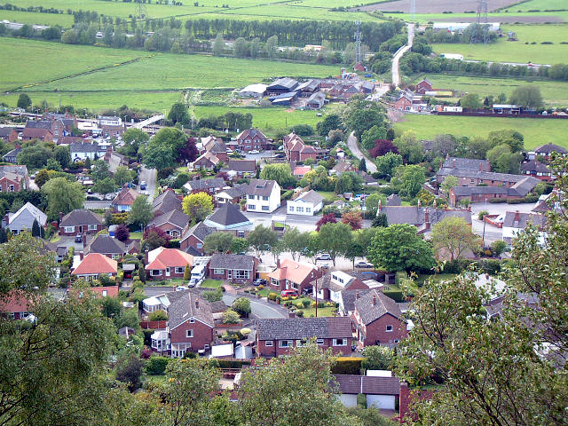
English: Helsby Village. As seen from the very steep sandstone hill to the east. Taken from 492755 looking north west, the minor road bridge over the M56 can be seen towards the top of the picture with the radio/telephone mast close by. |
| Dyddiad | |
| Ffynhonnell | From geograph.org.uk |
| Awdur | Gary Rogers |
| Cydnabyddiaeth (required by the license) | Gary Rogers / Helsby Village / |
| Camera location | | View this and other nearby images on: OpenStreetMap |
|---|
_region:GB-GBN_heading:292.00&language=cy)
| Object location | | View this and other nearby images on: OpenStreetMap |
|---|
_region:GB-GBN_heading:292.00&language=cy)
Trwyddedu

|
This image was taken from the Geograph project collection. See this photograph's page on the Geograph website for the photographer's contact details. The copyright on this image is owned by Gary Rogers and is licensed for reuse under the Creative Commons Attribution-ShareAlike 2.0 license.
|
Trwyddedir y ffeil hon yn ôl termau'r drwydded Creative Commons Attribution-Share Alike 2.0 Generic.
Cydnabyddiaeth: Gary Rogers
- Mae'n rhydd i chi:
- rhannu – gallwch gopïo, dosbarthu a throsglwyddo'r gwaith
- ailwampio – gallwch addasu'r gwaith
- Ar yr amodau canlynol:
- cydnabyddiaeth – Mae'n rhaid i chi nodi manylion y gwaith hwn, rhoi dolen i'r drwydded, a nodi os y bu golygu arni, yn y modd a benwyd gan yr awdur neu'r trwyddedwr (ond heb awgrymu o gwbl eu bod yn eich cymeradwyo chi na'ch defnydd o'r gwaith).
- rhannu ar dermau tebyg – Os byddwch yn addasu'r gwaith hwn, neu yn ei drawsnewid, neu yn adeiladu arno, mae'n rhaid i chi ddosbarthu'r gwaith dan drwydded sy'n union yr un fath same a'r gwreiddiol.
Hanes y ffeil
Cliciwch ar ddyddiad / amser i weld y ffeil fel ag yr oedd bryd hynny.
| Dyddiad / Amser | Bawdlun | Hyd a lled | Defnyddiwr | Sylw | |
|---|---|---|---|---|---|
| cyfredol | 08:01, 1 Chwefror 2013 | | 640 × 480 (438 KB) | Citypeek | white balance |
| 03:14, 30 Ionawr 2010 |  | 640 × 480 (131 KB) | GeographBot | == {{int:filedesc}} == {{Information |description={{en|1=Helsby Village. As seen from the very steep sandstone hill to the east. Taken from 492755 looking north west, the minor road bridge over the M56 can be seen towards the top of the picture with the r |
Cysylltiadau'r ffeil
Mae'r 1 tudalennau a ddefnyddir isod yn cysylltu i'r ddelwedd hon:
Defnydd cydwici y ffeil
Mae'r wicis eraill hyn yn defnyddio'r ffeil hon:
- Y defnydd ar ar.wikipedia.org
- Y defnydd ar arz.wikipedia.org
- Y defnydd ar azb.wikipedia.org
- Y defnydd ar ceb.wikipedia.org
- Y defnydd ar en.wikipedia.org
- Y defnydd ar es.wikipedia.org
- Y defnydd ar fa.wikipedia.org
- Y defnydd ar fr.wikipedia.org
- Y defnydd ar it.wikipedia.org
- Y defnydd ar lld.wikipedia.org
- Y defnydd ar pl.wikipedia.org
- Y defnydd ar www.wikidata.org
- Y defnydd ar zh-min-nan.wikipedia.org