Delwedd:Karte Voelkerschlacht bei Leipzig 18 Oktober 1813.png

Maint y rhagolwg: 601 × 599 picsel. Eglurdebau eraill: 241 × 240 picsel | 481 × 480 picsel | 741 × 739 picsel.
Maint llawn ((741 × 739 picsel, maint y ffeil: 134 KB, ffurf MIME: image/png))
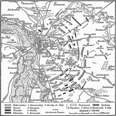
Historic map of the battle of the nations by Leipzig (18.10.1813)
| This image comes from the 4th edition of Meyers Konversationslexikon (1885–90). The copyrights have expired and this image is in the public domain. |
|
This work is in the public domain in its country of origin and other countries and areas where the copyright term is the author's life plus 100 years or fewer. This work is in the public domain in the United States because it was published (or registered with the U.S. Copyright Office) before January 1, 1929. | |
| Canfyddwyd bod y ffeil yn rhydd o gyfyngiadau yn ôl cyfraith hawlfraint, gan gynnwys pob hawl perthynol a chyfagos. | |
Hanes y ffeil
Cliciwch ar ddyddiad / amser i weld y ffeil fel ag yr oedd bryd hynny.
| Dyddiad / Amser | Bawdlun | Hyd a lled | Defnyddiwr | Sylw | |
|---|---|---|---|---|---|
| cyfredol | 13:12, 12 Rhagfyr 2004 | | 741 × 739 (134 KB) | ¡0-8-15! | {{PD-Meyers}} |
Cysylltiadau'r ffeil
Mae'r 1 tudalennau a ddefnyddir isod yn cysylltu i'r ddelwedd hon:
Defnydd cydwici y ffeil
Mae'r wicis eraill hyn yn defnyddio'r ffeil hon:
- Y defnydd ar ar.wikipedia.org
- Y defnydd ar br.wikipedia.org
- Y defnydd ar bs.wikipedia.org
- Y defnydd ar ckb.wikipedia.org
- Y defnydd ar de.wikivoyage.org
- Y defnydd ar en.wikipedia.org
- Y defnydd ar fr.wikipedia.org
- Y defnydd ar id.wikipedia.org
- Y defnydd ar ja.wikipedia.org
- Y defnydd ar ko.wikipedia.org
- Y defnydd ar mk.wikipedia.org
- Y defnydd ar nl.wikipedia.org
- Y defnydd ar pam.wikipedia.org
- Y defnydd ar sh.wikipedia.org
- Y defnydd ar sr.wikipedia.org
- Y defnydd ar uk.wikipedia.org
- Y defnydd ar vi.wikipedia.org
- Y defnydd ar www.wikidata.org
- Y defnydd ar zh-yue.wikipedia.org