Delwedd:Kukenan Roraima GS.jpg

Maint llawn ((4,851 × 1,533 picsel, maint y ffeil: 3.64 MB, ffurf MIME: image/jpeg))
Crynodeb
| Disgrifiad |
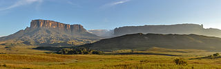
English: Morning view of Kukenan and Roraima tepuis, from Tëk river camp (river visible in the image), in Gran Sabana, Venezuela. Roraima tepui is actually some 100 mts higher than Kukenan, but due to the perspective of the picture, it looks like it is lower.
Español: Vista matutina de los tepuys Kukenan y Roraima, desde el campamente del río Tëk (con el río visible en la imagen), en la Gran Sabana, Venezuela. El tepuy Roraima es en realidad unos cien metros más alto que el Kukenan, aunque por la perspectiva de la foto, parece lo contrario.
Français : Vue matinale sur le Tepuy Kukenan et le Mont Roraima, depuis le camp de la rivière Tëk, dans la Gran Sabana (Vénézuela). Le Roraima Fait 100 m de plus que le Kukenan, bien qu'il apparaisse moins haut sur l'image, à cause de la perspective.
Bosanski: Jutarnja panorama Kukenana i tepui planine Roraima, iz riječnog kampa Tëk, Gran Sabana, Venecuela.
Italiano: Panorama al mattino dei tepui di Kukenan e Roraima dal campo sul fiume Tëk, Gran Sabana in Venezuela.
|
|||
| Dyddiad | ||||
| Ffynhonnell | Gwaith yr uwchlwythwr | |||
| Awdur | Paolo Costa Baldi | |||
| Caniatâd (Ailddefnyddio'r ffeil hon) |
|
| Camera location | | View this and other nearby images on: OpenStreetMap |
|---|
|
This image was selected as picture of the day on Wikimedia Commons for 10 July 2015. It was captioned as follows: Other languages:
Bosanski: Jutarnja panorama Kukenana i tepui planine Roraima, iz riječnog kampa Tëk, Gran Sabana, Venecuela. Español: Vista matutina de los tepuys Kukenan y Roraima, desde el campamente del río Tëk (con el río visible en la imagen), en la Gran Sabana, Venezuela. Italiano: Panorama al mattino dei tepui di Kukenan e Roraima dal campo sul fiume Tëk, Gran Sabana in Venezuela. |
Trwyddedu
- Mae'n rhydd i chi:
- rhannu – gallwch gopïo, dosbarthu a throsglwyddo'r gwaith
- ailwampio – gallwch addasu'r gwaith
- Ar yr amodau canlynol:
- cydnabyddiaeth – Mae'n rhaid i chi nodi manylion y gwaith hwn, rhoi dolen i'r drwydded, a nodi os y bu golygu arni, yn y modd a benwyd gan yr awdur neu'r trwyddedwr (ond heb awgrymu o gwbl eu bod yn eich cymeradwyo chi na'ch defnydd o'r gwaith).
- rhannu ar dermau tebyg – Os byddwch yn addasu'r gwaith hwn, neu yn ei drawsnewid, neu yn adeiladu arno, mae'n rhaid i chi ddosbarthu'r gwaith dan drwydded sy'n union yr un fath same a'r gwreiddiol.

|
Caniateir copïo, dosbarthu a/neu golygu'r ddogfen hon yn ôl telerau'r Drwydded Ddogfennaeth Rydd GNU, Fersiwn 1.2 neu unrhyw fersiwn diweddarach a gyhoeddwyd gan y Free Software Foundation; yn cynnwys dim Adrannau Di-syfl, dim Testunau Clawr Blaen, a dim Testunau Clawr Cefn. Cynhwysir copi o'r drwydded hon yn yr adran Trwydded Ddogfennaeth Rydd GNU". |
| Annotations | This image is annotated: View the annotations at Commons |
Hanes y ffeil
Cliciwch ar ddyddiad / amser i weld y ffeil fel ag yr oedd bryd hynny.
| Dyddiad / Amser | Bawdlun | Hyd a lled | Defnyddiwr | Sylw | |
|---|---|---|---|---|---|
| cyfredol | 03:42, 20 Hydref 2011 | 4,851 × 1,533 (3.64 MB) | Paolostefano1412 | {{Information |Description ={{en|1=Morning view of Kukenan and Roraima tepuis, from River Tëk camp (river visible in the image).}} {{es|1=Vista matutina de los tepuys Kukenan y Roraima, desde el campamente del río Tëk (con el río visible en la imag |
Cysylltiadau'r ffeil
Mae'r 1 tudalennau a ddefnyddir isod yn cysylltu i'r ddelwedd hon:
Defnydd cydwici y ffeil
Mae'r wicis eraill hyn yn defnyddio'r ffeil hon:
- Y defnydd ar ast.wikipedia.org
- Y defnydd ar av.wikipedia.org
- Y defnydd ar az.wikipedia.org
- Y defnydd ar be-tarask.wikipedia.org
- Y defnydd ar bn.wikipedia.org
- Y defnydd ar bs.wikipedia.org
- Y defnydd ar crh.wikipedia.org
- Y defnydd ar cs.wikipedia.org
- Y defnydd ar cv.wikipedia.org
- Y defnydd ar da.wikipedia.org
- Y defnydd ar de.wikipedia.org
- Y defnydd ar en.wikipedia.org
- Wikipedia:WikiProject Protected areas
- Gran Sabana
- Portal:Venezuela
- Wikipedia:Featured pictures/Places/Panorama
- Talk:Gran Sabana
- User talk:Paolostefano1412
- Wikipedia:WikiProject Geology/Recognized content
- Wikipedia:Featured pictures thumbs/33
- Wikipedia:Featured picture candidates/January-2013
- User talk:Razr Nation/2013/2
- Wikipedia:Featured picture candidates/Kukenan Roraima GS
- User:Razr Nation/FPs
- Distribution of Heliamphora
- Eastern Tepuis
- Wikipedia:Picture of the day/May 2014
- User talk:Razr Nation/2014/4
- Template:POTD/2014-05-29
- Wikipedia:Main Page history/2014 May 29
- Wikipedia:WikiProject Geology/Automated list of recognized content
- Raleigh's El Dorado expedition
- Portal:Venezuela/Recognized content
- Y defnydd ar en.wikivoyage.org
- Y defnydd ar es.wikipedia.org
- La Gran Sabana
- Anexo:Patrimonio de la Humanidad en América Latina y el Caribe
- Wikipedia:Imágenes destacadas/Lugares/Sudamérica
- Wikipedia:Recurso del día/501 - 600
- Wikipedia:Candidatos a recursos destacados/Diciembre-2011
- Wikipedia:Candidatos a recursos destacados/Kukenan Roraima GS.jpg
- Plantilla:RDD/556
- Wikipedia:Recurso del día/enero de 2012
- Wikipedia:Recurso del día/febrero de 2013
- Usuario discusión:Eduardosalg/Archivo57/Archivo56/Archivo39
- Usuario:JosueCarrion
- Usuario:Eduardosalg/Vitrina
- Usuario:Leanex77
- Wikipedia:Recurso del día/abril de 2015
Gweld rhagor o'r defnydd cydwici o'r ffeil hon.