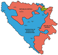
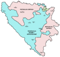
Delwedd:Map Bih entities.png

Maint y rhagolwg: 633 × 599 picsel. Eglurdebau eraill: 254 × 240 picsel | 507 × 480 picsel | 811 × 768 picsel | 1,103 × 1,044 picsel.
Maint llawn ((1,103 × 1,044 picsel, maint y ffeil: 67 KB, ffurf MIME: image/png))
Hanes y ffeil
Cliciwch ar ddyddiad / amser i weld y ffeil fel ag yr oedd bryd hynny.
| Dyddiad / Amser | Bawdlun | Hyd a lled | Defnyddiwr | Sylw | |
|---|---|---|---|---|---|
| cyfredol | 21:38, 6 Gorffennaf 2010 |  | 1,103 × 1,044 (67 KB) | PANONIAN | Reverted to version as of 23:51, 12 March 2010 - I do not agree that these are better colours. it is subjective opinion and it is bad idea that every user should upload new file version because he have different opinion about "better" colours |
| 12:26, 6 Gorffennaf 2010 |  | 1,103 × 1,044 (58 KB) | Mostarac | better colors | |
| 12:25, 6 Gorffennaf 2010 |  | 1,103 × 1,044 (58 KB) | Mostarac | better colors and cities. | |
| 23:51, 12 Mawrth 2010 |  | 1,103 × 1,044 (67 KB) | Dungodung | Well, I beg to differ. This one shows cities and is of better quality | |
| 11:55, 9 Mawrth 2010 |  | 700 × 615 (172 KB) | Mostarac | revert, bolje boje! | |
| 21:10, 20 Rhagfyr 2009 |  | 1,103 × 1,044 (67 KB) | PANONIAN | improved version | |
| 08:05, 16 Gorffennaf 2007 |  | 700 × 615 (13 KB) | Nihad Hamzic | This image was once a JPEG, the author had simply directly converted it to JPEG. I have grealty optimised its size by removing JPEG artifacts, and reducing color domain. | |
| 22:42, 28 Ionawr 2006 |  | 700 × 615 (172 KB) | (:Julien:) | Map of the 2 entities of the BiH and the Brčko district, author: en:User:PANONIAN, source: en:Image:M_bih03.png, PANONIAN is the creator and released it under PD. Category:Bosnia and Herzegovina |
Cysylltiadau'r ffeil
Mae'r 1 tudalennau a ddefnyddir isod yn cysylltu i'r ddelwedd hon:
Defnydd cydwici y ffeil
Mae'r wicis eraill hyn yn defnyddio'r ffeil hon:
- Y defnydd ar af.wikipedia.org
- Y defnydd ar ami.wikipedia.org
- Y defnydd ar am.wikipedia.org
- Y defnydd ar arc.wikipedia.org
- Y defnydd ar ar.wikipedia.org
- Y defnydd ar arz.wikipedia.org
- Y defnydd ar ast.wikipedia.org
- Y defnydd ar az.wikipedia.org
- Y defnydd ar bat-smg.wikipedia.org
- Y defnydd ar be-tarask.wikipedia.org
- Y defnydd ar bi.wikipedia.org
- Y defnydd ar bjn.wikipedia.org
- Y defnydd ar bn.wikipedia.org
- Y defnydd ar bo.wikipedia.org
- Y defnydd ar bpy.wikipedia.org
- Y defnydd ar br.wikipedia.org
- Y defnydd ar bs.wikipedia.org
- Y defnydd ar ca.wikipedia.org
- Y defnydd ar ceb.wikipedia.org
- Y defnydd ar ce.wikipedia.org
- Y defnydd ar ckb.wikipedia.org
- Y defnydd ar co.wikipedia.org
- Y defnydd ar crh.wikipedia.org
- Y defnydd ar csb.wikipedia.org
- Y defnydd ar cs.wikipedia.org
- Y defnydd ar cs.wikinews.org
- Y defnydd ar cv.wikipedia.org
- Y defnydd ar da.wikipedia.org
- Y defnydd ar de.wikipedia.org
- Y defnydd ar diq.wikipedia.org
- Y defnydd ar dv.wikipedia.org
- Y defnydd ar ee.wikipedia.org
- Y defnydd ar el.wikipedia.org
- Y defnydd ar en.wikipedia.org
- Bosnia and Herzegovina
- History of Bosnia and Herzegovina
- Multinational state
- Republika Srpska (1992–1995)
- Inter-Entity Boundary Line
- Talk:Inter-Entity Boundary Line
- Portal:Bosnia and Herzegovina
- User:Jonny-mt/Gallery of current first-level administrative country subdivisions maps
- Politics of country subdivisions
- Talk:Federation of Bosnia and Herzegovina/Archive 1
- Y defnydd ar en.wikivoyage.org
- Y defnydd ar eo.wikipedia.org
Gweld rhagor o'r defnydd cydwici o'r ffeil hon.


