Delwedd:Map of Finland-en.svg

Maint rhagolwg PNG o ffeil SVG yw: 409 × 599 picsel. Eglurdebau eraill: 164 × 240 picsel | 328 × 480 picsel | 524 × 768 picsel | 699 × 1,024 picsel | 1,399 × 2,048 picsel | 1,371 × 2,007 picsel.
Maint llawn (Ffeil SVG, maint mewn enw 1,371 × 2,007 picsel, maint y ffeil: 3.57 MB)
Crynodeb
| Disgrifiad |
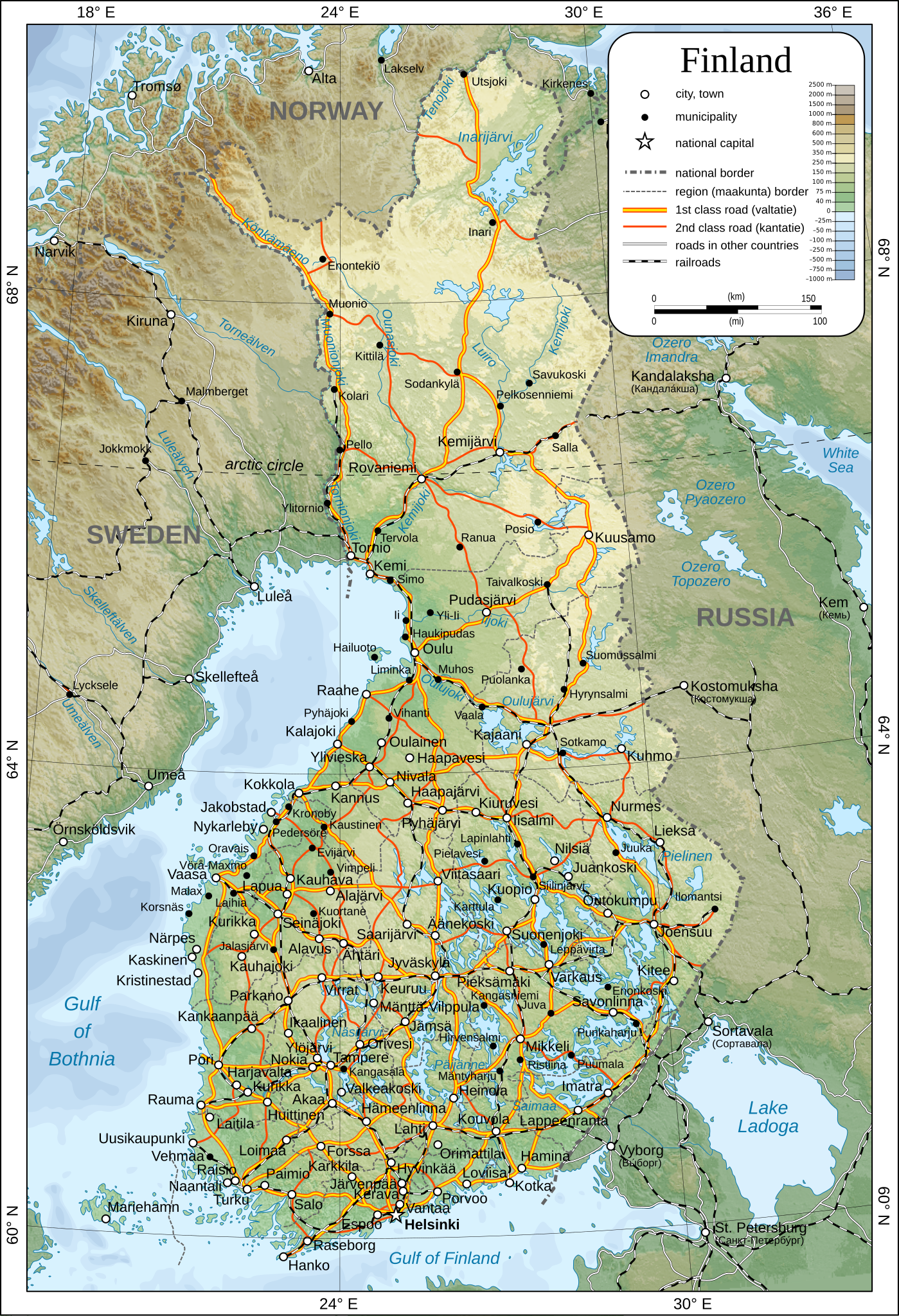
English: Map of Finland.
Suomi: Suomen kartta.
Svenska: Karta över Finland.
|
| Dyddiad | |
| Ffynhonnell | Gwaith yr uwchlwythwr |
| Awdur | Oona Räisänen |
| Caniatâd (Ailddefnyddio'r ffeil hon) |
See below. I've worked hard to create this map, so even though not mandatory, please attribute me wherever it is suitable. |
| Diwygiadau eraill |
[]
|
| SVG genesis |


Trwyddedu
| Yr wyf fi, deiliad hawlfraint y gwaith hwn, yn ei ryddhau i'r parth cyhoeddus, a hynny'n fyd-eang. Hwyrach nad yw hyn yn bosib yn ôl cyfraith rhai gwledydd; os felly: Rwyn rhoi i unrhywun yr hawl i ddefnyddio'r gwaith hwn at unrhyw ddiben, heb unrhyw amodau, oddieithr unrhyw amodau gofynnol yn ôl y gyfraith. |
Hanes y ffeil
Cliciwch ar ddyddiad / amser i weld y ffeil fel ag yr oedd bryd hynny.
| Dyddiad / Amser | Bawdlun | Hyd a lled | Defnyddiwr | Sylw | |
|---|---|---|---|---|---|
| cyfredol | 13:44, 26 Rhagfyr 2009 | | 1,371 × 2,007 (3.57 MB) | Mysid | added some cities, municipalities, and height color legend |
| 10:18, 24 Rhagfyr 2009 |  | 1,371 × 2,007 (3.46 MB) | Mysid | updated with topography, bathymetry, and revised provinces | |
| 00:40, 5 Mawrth 2009 |  | 1,371 × 2,007 (886 KB) | Mysid | fonts | |
| 00:37, 5 Mawrth 2009 |  | 1,371 × 2,007 (885 KB) | Mysid | {{Information |Description={{en|1=Map of w:Finland.}} {{fi|1=Suomen kartta.}} {{sv|1=Karta över sv:Finland.}} |Source=Self-made in Inkscape after CIA. |Author=Mysid |Date=2009-03-05 |Permission= |other_versions= |
Cysylltiadau'r ffeil
Mae'r 1 tudalennau a ddefnyddir isod yn cysylltu i'r ddelwedd hon:
Defnydd cydwici y ffeil
Mae'r wicis eraill hyn yn defnyddio'r ffeil hon:
- Y defnydd ar af.wikipedia.org
- Y defnydd ar ar.wikipedia.org
- Y defnydd ar avk.wikipedia.org
- Y defnydd ar be.wikipedia.org
- Y defnydd ar bg.wikipedia.org
- Y defnydd ar cs.wikipedia.org
- Y defnydd ar de.wikipedia.org
- Y defnydd ar en.wikipedia.org
- Y defnydd ar fa.wikipedia.org
- Y defnydd ar fr.wikipedia.org
- Y defnydd ar he.wikipedia.org
- Y defnydd ar hr.wiktionary.org
- Y defnydd ar hy.wikipedia.org
- Y defnydd ar io.wikipedia.org
- Y defnydd ar ja.wikipedia.org
- Y defnydd ar ka.wikipedia.org
- Y defnydd ar mk.wikipedia.org
- Y defnydd ar nl.wikipedia.org
- Y defnydd ar pl.wikipedia.org
- Y defnydd ar pl.wiktionary.org
- Y defnydd ar pnb.wikipedia.org
- Y defnydd ar rm.wikipedia.org
- Y defnydd ar ro.wikipedia.org
- Y defnydd ar ru.wikipedia.org
- Y defnydd ar sco.wikipedia.org
- Y defnydd ar simple.wikipedia.org
- Y defnydd ar sr.wikipedia.org
- Y defnydd ar tr.wikipedia.org
- Y defnydd ar uk.wikipedia.org
- Y defnydd ar zh.wikipedia.org