Delwedd:Mayotte, vue par Sentinel 2 (cropped).jpg

Maint llawn ((4,100 × 4,381 picsel, maint y ffeil: 11.67 MB, ffurf MIME: image/jpeg))
Crynodeb
| Disgrifiad |
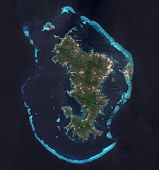
Français : L'ile de Mayotte dans l’océan indien vue par le satellite Sentinel 2, le 14 aout 2021.
English: Mayotte island (Indian Ocean) photographed by satellite Sentinel 2 on 14th August 2021. |
| Dyddiad | |
| Ffynhonnell | https://phototheque.cnes.fr/cnes/media/68576 |
| Awdur | European Space Agency / CNES |
| Diwygiadau eraill |
_(cropped).jpg)

.jpg)
| Camera location | | View this and other nearby images on: OpenStreetMap |
|---|
.jpg¶ms=-12.843056_N_0045.138333_E_globe:Earth_type:camera__&language=cy)
Trwyddedu

|
This image contains data from a satellite in the Copernicus Programme, such as Sentinel-1, Sentinel-2 or Sentinel-3. Attribution is required when using this image.
Cydnabyddiaeth: Contains modified Copernicus Sentinel data 2021
The use of Copernicus Sentinel Data is regulated under EU law (Commission Delegated Regulation (EU) No 1159/2013 and Regulation (EU) No 377/2014). Relevant excerpts:
Free access shall be given to GMES dedicated data [...] made available through GMES dissemination platforms [...].
Access to GMES dedicated data [...] shall be given for the purpose of the following use in so far as it is lawful:
GMES dedicated data [...] may be used worldwide without limitations in time.
GMES dedicated data and GMES service information are provided to users without any express or implied warranty, including as regards quality and suitability for any purpose. |

|
This image has been assessed under the valued image criteria and is considered the most valued image on Commons within the scope: Mayotte island, France - satellite view.. You can see its nomination here. |
.jpg)
Hanes y ffeil
Cliciwch ar ddyddiad / amser i weld y ffeil fel ag yr oedd bryd hynny.
| Dyddiad / Amser | Bawdlun | Hyd a lled | Defnyddiwr | Sylw | |
|---|---|---|---|---|---|
| cyfredol | 11:52, 17 Chwefror 2022 | | 4,100 × 4,381 (11.67 MB) | Don-vip | File:Mayotte, vue par Sentinel 2.jpg cropped 18 % horizontally, 12 % vertically using CropTool with lossless mode. |
Cysylltiadau'r ffeil
Mae'r 1 tudalennau a ddefnyddir isod yn cysylltu i'r ddelwedd hon:
Defnydd cydwici y ffeil
Mae'r wicis eraill hyn yn defnyddio'r ffeil hon:
- Y defnydd ar ar.wikipedia.org
- Y defnydd ar arz.wikipedia.org
- Y defnydd ar ast.wikipedia.org
- Y defnydd ar az.wikipedia.org
- Y defnydd ar ca.wikipedia.org
- Y defnydd ar ceb.wikipedia.org
- Y defnydd ar ce.wikipedia.org
- Y defnydd ar de.wikivoyage.org
- Y defnydd ar eo.wikipedia.org
- Y defnydd ar es.wikipedia.org
- Y defnydd ar fr.wikipedia.org
- Y defnydd ar fr.wikinews.org
- Y defnydd ar fr.wikivoyage.org
- Y defnydd ar ga.wikipedia.org
- Y defnydd ar gl.wikipedia.org
- Y defnydd ar hy.wikipedia.org
- Y defnydd ar ig.wikipedia.org
- Y defnydd ar mg.wikipedia.org
- Y defnydd ar no.wikipedia.org
- Y defnydd ar oc.wikipedia.org
- Y defnydd ar pl.wikipedia.org
- Y defnydd ar ps.wikipedia.org
- Y defnydd ar ru.wikinews.org
- Y defnydd ar tl.wikipedia.org
- Y defnydd ar tt.wikipedia.org
- Y defnydd ar vi.wikipedia.org
- Y defnydd ar www.wikidata.org
.jpg)