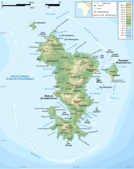
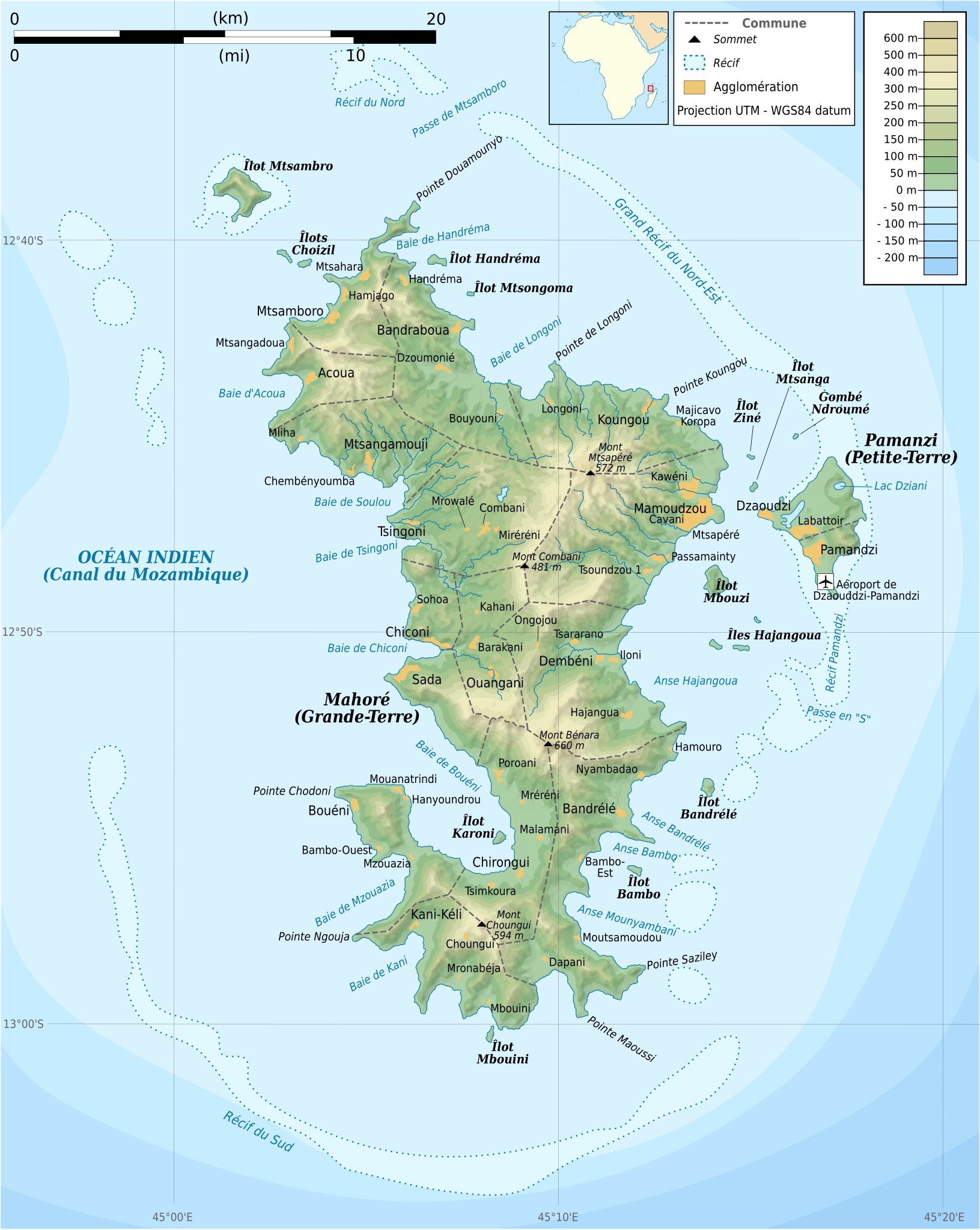
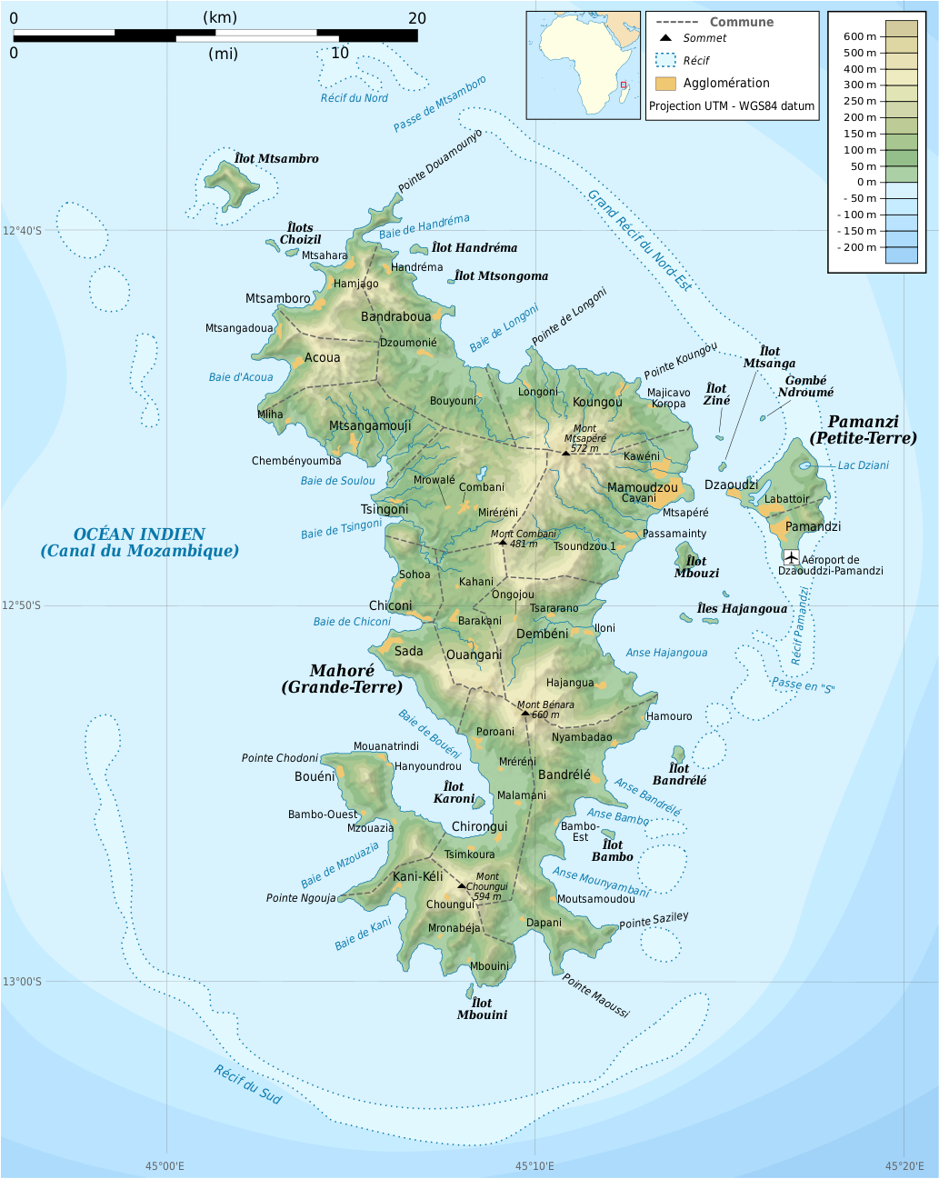
Delwedd:Mayotte topographic map-fr.svg

Maint rhagolwg PNG o ffeil SVG yw: 477 × 599 picsel. Eglurdebau eraill: 191 × 240 picsel | 382 × 480 picsel | 612 × 768 picsel | 815 × 1,024 picsel | 1,631 × 2,048 picsel | 1,033 × 1,297 picsel.
Maint llawn (Ffeil SVG, maint mewn enw 1,033 × 1,297 picsel, maint y ffeil: 874 KB)
Crynodeb
| Disgrifiad |
Français : Carte topographique de Mayotte en français. Utiliser la version PNG dans les articles pour un rendu plus rapide.
|
| Dyddiad | |
| Ffynhonnell |
Own work. Sources of data:
|
| Awdur | Rémi Kaupp |
| Diwygiadau eraill |
[]
|


English: This map has been created by Rémi Kaupp (User:Korrigan) and released under the license(s) stated below. You are free to use it for any purpose as long as you credit me and follow the terms of the license. You may need to credit the sources of data of the map (please check). Example:
Français : Cette carte a été créée par Rémi Kaupp (User:Korrigan) et placée sous la ou les licence(s) ci-dessous. Vous êtes libre de la réutiliser, tant que vous me citez en tant qu'auteur et suivez les instructions de la licence. Certaines sources de données de la carte doivent peut-être être créditées, veuillez vérifier. Exemple :
|
 |
Trwyddedu
Yr wyf fi, deiliad yr hawlfraint ar y gwaith hwn, yn ei gyhoeddi yn ôl termau'r trwyddedau a ganlyn:

|
Caniateir copïo, dosbarthu a/neu golygu'r ddogfen hon yn ôl telerau'r Drwydded Ddogfennaeth Rydd GNU, Fersiwn 1.2 neu unrhyw fersiwn diweddarach a gyhoeddwyd gan y Free Software Foundation; yn cynnwys dim Adrannau Di-syfl, dim Testunau Clawr Blaen, a dim Testunau Clawr Cefn. Cynhwysir copi o'r drwydded hon yn yr adran Trwydded Ddogfennaeth Rydd GNU". |
This file is licensed under the Creative Commons Attribution-Share Alike 4.0 International, 3.0 Unported, 2.5 Generic, 2.0 Generic and 1.0 Generic license.
- Mae'n rhydd i chi:
- rhannu – gallwch gopïo, dosbarthu a throsglwyddo'r gwaith
- ailwampio – gallwch addasu'r gwaith
- Ar yr amodau canlynol:
- cydnabyddiaeth – Mae'n rhaid i chi nodi manylion y gwaith hwn, rhoi dolen i'r drwydded, a nodi os y bu golygu arni, yn y modd a benwyd gan yr awdur neu'r trwyddedwr (ond heb awgrymu o gwbl eu bod yn eich cymeradwyo chi na'ch defnydd o'r gwaith).
- rhannu ar dermau tebyg – Os byddwch yn addasu'r gwaith hwn, neu yn ei drawsnewid, neu yn adeiladu arno, mae'n rhaid i chi ddosbarthu'r gwaith dan drwydded sy'n union yr un fath same a'r gwreiddiol.
Gallwch ddewis y drwydded y mynnwch.
Hanes y ffeil
Cliciwch ar ddyddiad / amser i weld y ffeil fel ag yr oedd bryd hynny.
| Dyddiad / Amser | Bawdlun | Hyd a lled | Defnyddiwr | Sylw | |
|---|---|---|---|---|---|
| cyfredol | 20:55, 24 Mawrth 2009 | | 1,033 × 1,297 (874 KB) | Korrigan | {{Information |Description={{en|Topographic map of Mayotte in French. Use the PNG version in articles for faster loading.}} {{fr|Carte topographique de Mayotte en français. Utiliser [[:File:Mayotte_topographic |
Cysylltiadau'r ffeil
Nid oes tudalennau'n defnyddio'r ffeil hon.
Defnydd cydwici y ffeil
Mae'r wicis eraill hyn yn defnyddio'r ffeil hon:
- Y defnydd ar ar.wikipedia.org
- Y defnydd ar az.wikipedia.org
- Y defnydd ar br.wikipedia.org
- Y defnydd ar ca.wikipedia.org
- Y defnydd ar ce.wikipedia.org
- Y defnydd ar cs.wikipedia.org
- Y defnydd ar en.wikipedia.org
- Y defnydd ar es.wikipedia.org
- Y defnydd ar fr.wikipedia.org
- Y defnydd ar ga.wikipedia.org
- Y defnydd ar gl.wikipedia.org
- Y defnydd ar io.wikipedia.org
- Y defnydd ar is.wikipedia.org
- Y defnydd ar it.wikipedia.org
- Y defnydd ar ja.wikipedia.org
- Y defnydd ar la.wikipedia.org
- Y defnydd ar nl.wikipedia.org
- Y defnydd ar pl.wiktionary.org
- Y defnydd ar ru.wikipedia.org
- Y defnydd ar sc.wikipedia.org
- Y defnydd ar tt.wikipedia.org
- Y defnydd ar uk.wikipedia.org
- Y defnydd ar www.wikidata.org