Delwedd:MerguiArchipelagoMap.png
Maint y rhagolwg: 322 × 598 picsel. Eglurdebau eraill: 129 × 240 picsel | 258 × 480 picsel | 973 × 1,808 picsel.
Maint llawn ((973 × 1,808 picsel, maint y ffeil: 61 KB, ffurf MIME: image/png))
Crynodeb
| Disgrifiad |
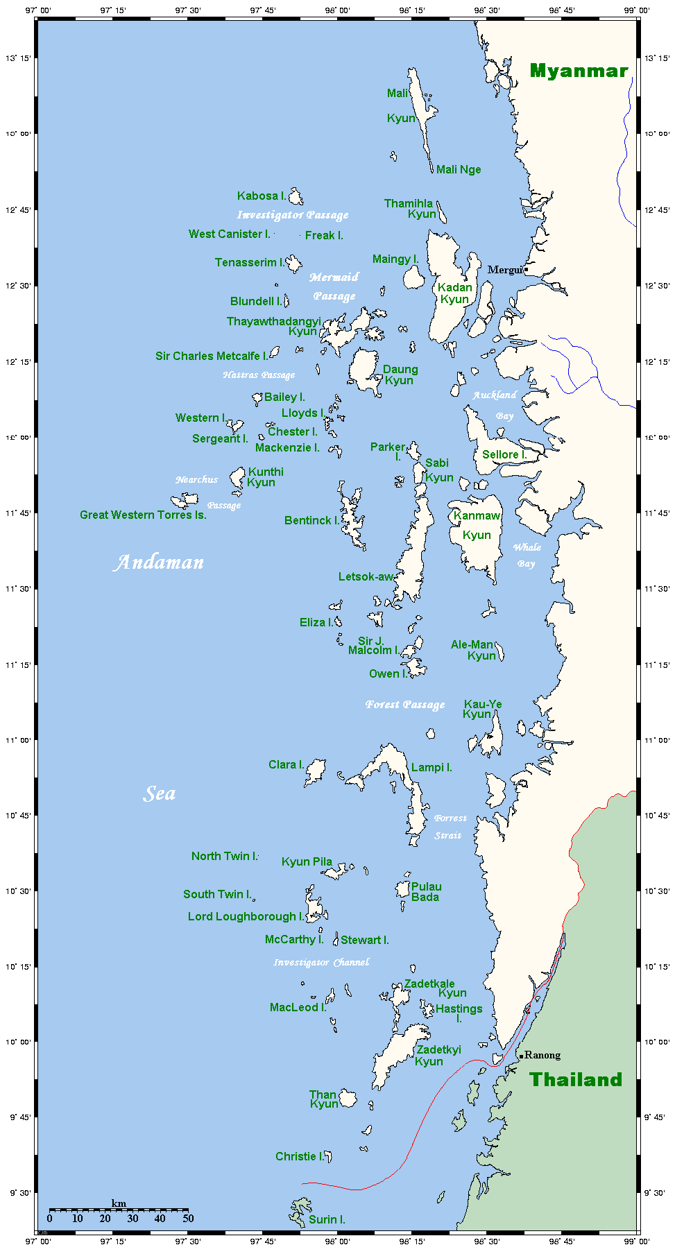
Map of the Mergui Archipelago in Myanmar. This map's source is here, with the uploader's modifications, and the GMT homepage says that the tools are released under the GNU General Public License. There is a somewhat bigger map of this area, showing places farther north and south. This is not on Wikipedia, but leave a message at my talk page if you would like such a thing, and likewise if you know any further information that ought to go on this map. |
| Dyddiad | 14 Mai 2006 (original upload date) |
| Ffynhonnell | Transferred from en.wikipedia to Commons. |
| Awdur | Kelisi at Saesneg Wicipedia |

|
This map image could be re-created using vector graphics as an SVG file. This has several advantages; see Commons:Media for cleanup for more information. If an SVG form of this image is available, please upload it and afterwards replace this template with
{{vector version available|new image name}}.
It is recommended to name the SVG file “MerguiArchipelagoMap.svg”—then the template Vector version available (or Vva) does not need the new image name parameter. |
Trwyddedu
Mae Kelisi from en.wikipedia.org, deiliad yr hawlfraint ar y gwaith hwn, yn ei gyhoeddi yn ôl termau'r drwydded a ganlyn:
| Trwyddedir y ffeil hon yn ôl termau'r drwydded Creative Commons Attribution-Share Alike 3.0 Unported. Subject to disclaimers. | ||
| Cydnabyddiaeth: Kelisi from en.wikipedia.org | ||
| ||
| Ychwangwyd y nod trwyddedu hwn wrth y ffeil hon yn ran o'r gwaith o ddiweddaru trwyddedau GFDL. |

|
Caniateir copïo, dosbarthu a/neu golygu'r ddogfen hon yn ôl telerau'r Drwydded Ddogfennaeth Rydd GNU, Fersiwn 1.2 neu unrhyw fersiwn diweddarach a gyhoeddwyd gan y Free Software Foundation; yn cynnwys dim Adrannau Di-syfl, dim Testunau Clawr Blaen, a dim Testunau Clawr Cefn. Cynhwysir copi o'r drwydded hon yn yr adran Trwydded Ddogfennaeth Rydd GNU". Subject to disclaimers. |
Cofnod lòg yr uwchlwythiad gwreiddiol
The original description page was here. All following user names refer to en.wikipedia.
- 2006-05-14 20:32 Kelisi 973×1808×8 (62506 bytes) Map of the Mergui Archipelago in Myanmar. This map's source is [http://www.aquarius.geomar.de/omc/make_map.html here], with the uploader's modifications, and the [http://gmt.soest.hawaii.edu/ GMT homepage] says that the tools are released under the GNU Ge
Hanes y ffeil
Cliciwch ar ddyddiad / amser i weld y ffeil fel ag yr oedd bryd hynny.
| Dyddiad / Amser | Bawdlun | Hyd a lled | Defnyddiwr | Sylw | |
|---|---|---|---|---|---|
| cyfredol | 23:20, 1 Mai 2007 | | 973 × 1,808 (61 KB) | Ppntori | {{Information |Description=Map of the Mergui Archipelago in Myanmar. This map's source is [http://www.aquarius.geomar.de/omc/make_map.html here], with the uploader's modifications, and the [http://gmt.soest.hawaii.edu/ GMT homepage] says that the tools ar |
Cysylltiadau'r ffeil
Mae'r 1 tudalennau a ddefnyddir isod yn cysylltu i'r ddelwedd hon:
Defnydd cydwici y ffeil
Mae'r wicis eraill hyn yn defnyddio'r ffeil hon:
- Y defnydd ar ar.wikipedia.org
- Y defnydd ar arz.wikipedia.org
- Y defnydd ar ban.wikipedia.org
- Y defnydd ar bcl.wikipedia.org
- Y defnydd ar bg.wikipedia.org
- Y defnydd ar bh.wikipedia.org
- Y defnydd ar bn.wikipedia.org
- Y defnydd ar bs.wikipedia.org
- Y defnydd ar ca.wikipedia.org
- Y defnydd ar ckb.wikipedia.org
- Y defnydd ar de.wikipedia.org
- Y defnydd ar en.wikipedia.org
- Y defnydd ar es.wikipedia.org
- Y defnydd ar fa.wikipedia.org
- Y defnydd ar fi.wikipedia.org
- Y defnydd ar fr.wikipedia.org
- Y defnydd ar fy.wikipedia.org
- Y defnydd ar ga.wikipedia.org
- Y defnydd ar hi.wikipedia.org
- Y defnydd ar hu.wikipedia.org
- Y defnydd ar ia.wikipedia.org
- Y defnydd ar id.wikipedia.org
- Y defnydd ar ilo.wikipedia.org
- Y defnydd ar incubator.wikimedia.org
- Y defnydd ar io.wikipedia.org
- Y defnydd ar it.wikipedia.org
- Y defnydd ar ja.wikipedia.org
- Y defnydd ar jv.wikipedia.org
- Y defnydd ar kk.wikipedia.org
- Y defnydd ar km.wikipedia.org
- Y defnydd ar kn.wikipedia.org
- Y defnydd ar ko.wikipedia.org
- Y defnydd ar lt.wikipedia.org
- Y defnydd ar min.wikipedia.org
- Y defnydd ar mk.wikipedia.org
- Y defnydd ar ml.wikipedia.org
- Y defnydd ar mr.wikipedia.org
Gweld rhagor o'r defnydd cydwici o'r ffeil hon.