Delwedd:NiagaraRiverNASA.jpg
Maint y rhagolwg: 511 × 599 picsel. Eglurdebau eraill: 205 × 240 picsel | 409 × 480 picsel | 655 × 768 picsel | 873 × 1,024 picsel | 1,600 × 1,877 picsel.
Maint llawn ((1,600 × 1,877 picsel, maint y ffeil: 959 KB, ffurf MIME: image/jpeg))
Crynodeb
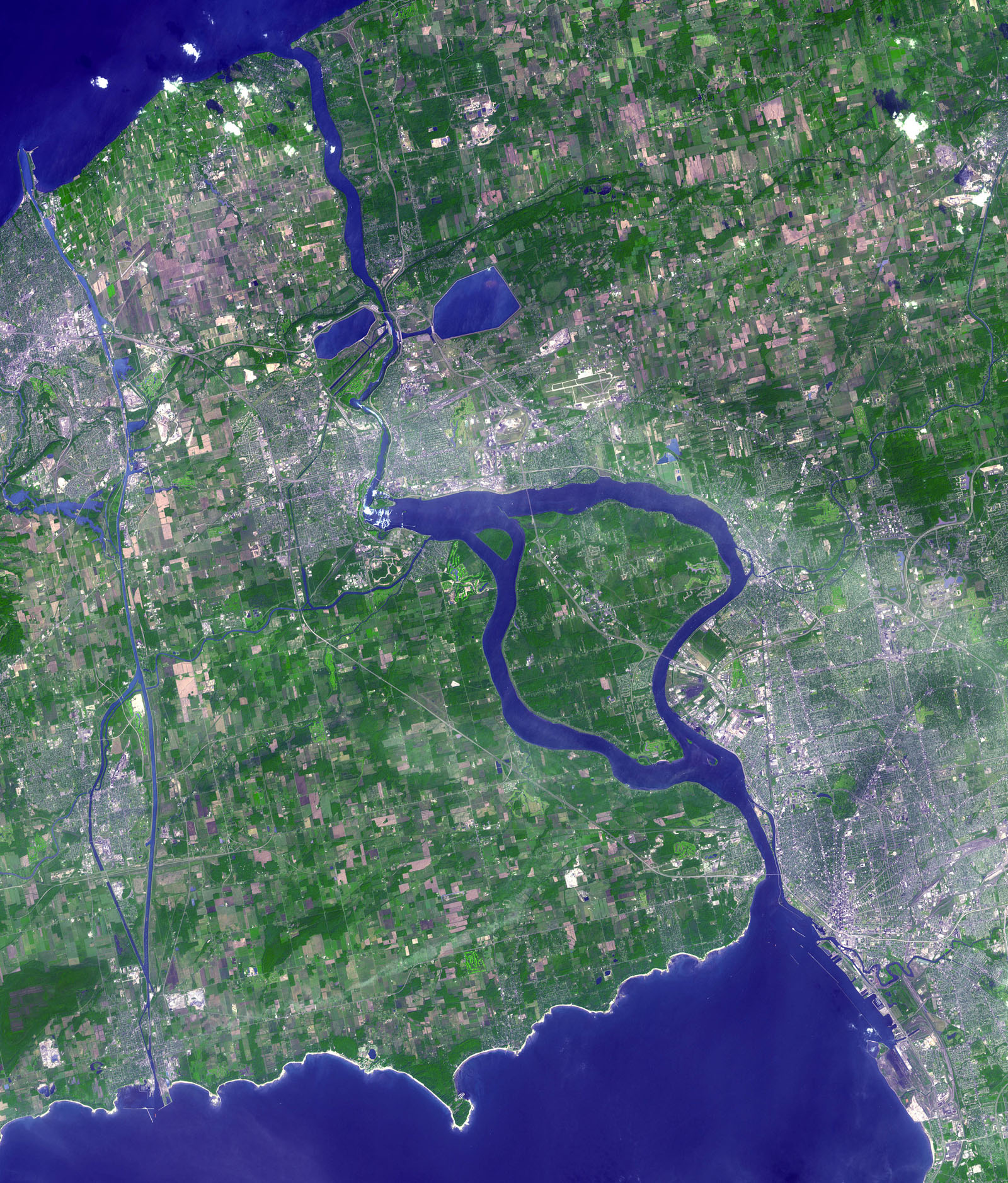
| Disgrifiad | Satellite image of the Niagara River, produced by NASA; acquired by the ASTER sensor on NASA's Terra satellite, September 8, 2001. |
| Dyddiad | Downloaded December 12, 2006 |
| Ffynhonnell | NASA Visible Earth; http://visibleearth.nasa.gov/view_rec.php?id=16362 |
| Awdur | Image courtesy NASA/GSFC/MITI/ERSDAC/JAROS, and U.S./Japan ASTER Science Team |
| Caniatâd (Ailddefnyddio'r ffeil hon) |
US Federal Government public domain, credit: NASA Visible Earth |
Trwyddedu
| This file is in the public domain in the United States because it was solely created by NASA. NASA copyright policy states that "NASA material is not protected by copyright unless noted". (See Template:PD-USGov, NASA copyright policy page or JPL Image Use Policy.) | ||
 |
Warnings:
|
| Annotations | This image is annotated: View the annotations at Commons |
Hanes y ffeil
Cliciwch ar ddyddiad / amser i weld y ffeil fel ag yr oedd bryd hynny.
| Dyddiad / Amser | Bawdlun | Hyd a lled | Defnyddiwr | Sylw | |
|---|---|---|---|---|---|
| cyfredol | 03:17, 13 Rhagfyr 2006 | | 1,600 × 1,877 (959 KB) | Pfly | {{Information |Description=Satellite image of the Niagara River, produced by NASA; acquired by the ASTER sensor on NASA's Terra satellite, September 8, 2001. |Source=NASA Visible Earth; http://visibleearth.nasa.gov/view_rec.php?id=16362 |Date=Downloaded D |
Cysylltiadau'r ffeil
Mae'r 1 tudalennau a ddefnyddir isod yn cysylltu i'r ddelwedd hon:
Defnydd cydwici y ffeil
Mae'r wicis eraill hyn yn defnyddio'r ffeil hon:
- Y defnydd ar ang.wikipedia.org
- Y defnydd ar ar.wikipedia.org
- Y defnydd ar arz.wikipedia.org
- Y defnydd ar az.wikipedia.org
- Y defnydd ar bn.wikipedia.org
- Y defnydd ar ca.wikipedia.org
- Y defnydd ar ceb.wikipedia.org
- Y defnydd ar ckb.wikipedia.org
- Y defnydd ar cs.wikipedia.org
- Y defnydd ar da.wikipedia.org
- Y defnydd ar de.wikipedia.org
- Y defnydd ar el.wikipedia.org
- Y defnydd ar en.wikipedia.org
- Y defnydd ar eo.wikipedia.org
- Y defnydd ar es.wikipedia.org
- Y defnydd ar et.wikipedia.org
- Y defnydd ar eu.wikipedia.org
- Y defnydd ar fa.wikipedia.org
- Y defnydd ar fi.wikipedia.org
- Y defnydd ar fo.wikipedia.org
- Y defnydd ar frr.wikipedia.org
- Y defnydd ar fr.wikipedia.org
- Y defnydd ar gl.wikipedia.org
- Y defnydd ar he.wikipedia.org
- Y defnydd ar ht.wikipedia.org
- Y defnydd ar hy.wikipedia.org
- Y defnydd ar is.wikipedia.org
- Y defnydd ar it.wikipedia.org
- Y defnydd ar ja.wikipedia.org
- Y defnydd ar kk.wikipedia.org
- Y defnydd ar ky.wikipedia.org
- Y defnydd ar mr.wikipedia.org
- Y defnydd ar ms.wikipedia.org
- Y defnydd ar no.wikipedia.org
- Y defnydd ar pl.wikipedia.org
- Y defnydd ar pl.wiktionary.org
- Y defnydd ar pt.wikipedia.org
- Y defnydd ar ro.wikipedia.org
- Y defnydd ar sk.wikipedia.org
- Y defnydd ar sr.wikipedia.org
- Y defnydd ar sw.wikipedia.org
Gweld rhagor o'r defnydd cydwici o'r ffeil hon.