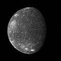
English: The New Horizons Long Range Reconnaissance Imager (LORRI) captured this image of Jupiter's outermost large moon, Callisto, as the spacecraft flew past Jupiter in late February. New Horizons' closest approach distance to Jupiter was 2.3 million kilometers (1.4 million miles), not far outside Callisto's orbit, which has a radius of 1.9 million kilometers (1.2 million miles). However, Callisto happened to be on the opposite side of Jupiter during the spacecraft's pass through the Jupiter system, so this image, taken from 4.7 million kilometers (3.0 million miles) away, is one of the closest of Callisto that New Horizons obtained.
Callisto's ancient, crater-scarred surface makes it very different from its three more active sibling satellites, Io, Europa and Ganymede. Callisto, 4,800 kilometers (3000 miles) in diameter, displays no large-scale geological features other than impact craters, and every bright spot in these images is a crater. The largest impact feature on Callisto, the huge basin Valhalla, is visible as a bright patch at the 10 o'clock position. The craters are bright because they have excavated material relatively rich in water ice from beneath the dark, dusty material that coats most of the surface.
This image of Callisto shows the side that faces Jupiter. The images accompanied scans of Callisto's infrared spectrum with New Horizons' Linear Etalon Imaging Spectral Array (LEISA). The New Horizons science team designed these scans to study how the infrared spectrum of Callisto's water ice changes as lighting and viewing conditions change, and as the ice cools through Callisto's late afternoon. The infrared spectrum of water ice depends slightly on its temperature, and a goal of New Horizons when it reaches the Pluto system (in 2015) is to use the water ice features in the spectrum of Pluto's moon Charon, and perhaps on Pluto itself, to measure surface temperature. Callisto provided an ideal opportunity to test this technique on a much better-known body.
This image, taken at 05:03 Universal Time on February 27, 2007, is centered at 5 degrees south, 5 degrees west, and has a solar phase angle of 46 degrees.


