Delwedd:River Nith estuary.jpg

Maint y rhagolwg: 800 × 533 picsel. Eglurdebau eraill: 320 × 213 picsel | 640 × 427 picsel | 1,024 × 683 picsel | 1,280 × 853 picsel | 2,560 × 1,707 picsel | 3,504 × 2,336 picsel.
Maint llawn ((3,504 × 2,336 picsel, maint y ffeil: 8.68 MB, ffurf MIME: image/jpeg))
Crynodeb
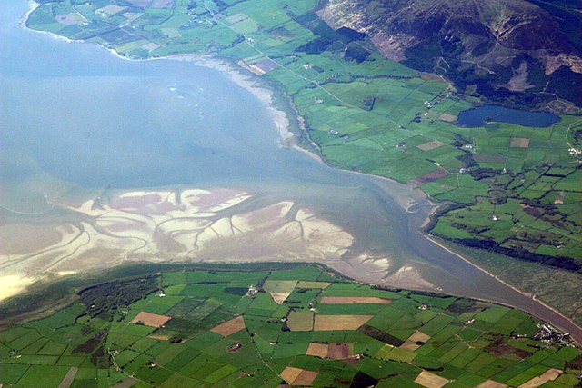
| Disgrifiad | The estuary of the River Nith, Scotland, at low tide; opening into Solway Firth. This is a view of the Nith estuary from the north-east. The group of buildings at bottom right is the village of Glencaple. At bottom left near the wooded area is Caerlaverock Castle. At top right is Loch Kindar and the hill above is called Criffel. Just beyond the top left of photo is the birthplace of John Paul Jones. |
| Dyddiad | |
| Ffynhonnell | https://www.flickr.com/photos/52614599@N00/483602946 |
| Awdur | Doc Searls from Santa Barbara, USA |
Trwyddedu
Trwyddedir y ffeil hon yn ôl termau'r drwydded Creative Commons Attribution-Share Alike 2.0 Generic.
- Mae'n rhydd i chi:
- rhannu – gallwch gopïo, dosbarthu a throsglwyddo'r gwaith
- ailwampio – gallwch addasu'r gwaith
- Ar yr amodau canlynol:
- cydnabyddiaeth – Mae'n rhaid i chi nodi manylion y gwaith hwn, rhoi dolen i'r drwydded, a nodi os y bu golygu arni, yn y modd a benwyd gan yr awdur neu'r trwyddedwr (ond heb awgrymu o gwbl eu bod yn eich cymeradwyo chi na'ch defnydd o'r gwaith).
- rhannu ar dermau tebyg – Os byddwch yn addasu'r gwaith hwn, neu yn ei drawsnewid, neu yn adeiladu arno, mae'n rhaid i chi ddosbarthu'r gwaith dan drwydded sy'n union yr un fath same a'r gwreiddiol.
| This image was originally posted to Flickr by dsearls at https://www.flickr.com/photos/52614599@N00/483602946. It was reviewed on 5 Mai 2007 by FlickreviewR and was confirmed to be licensed under the terms of the cc-by-sa-2.0. |
This is a view of the Nith estuary from the north-east. The group of buildings at bottom right is the village of Glencaple. At bottom left near the wooded area is Caerlaverock Castle. At top right is Loch Kindar and the hill above is called Criffel. Just beyond the top left of photo is the birthplace of John Paul Jones.
Hanes y ffeil
Cliciwch ar ddyddiad / amser i weld y ffeil fel ag yr oedd bryd hynny.
| Dyddiad / Amser | Bawdlun | Hyd a lled | Defnyddiwr | Sylw | |
|---|---|---|---|---|---|
| cyfredol | 07:14, 5 Mai 2007 | | 3,504 × 2,336 (8.68 MB) | Sandstein | {{Information |Description= The estuary of the River Nith, Scotland, at low tide; opening into Solway Firth. On the near shore, Bowness-on-Solway. On the far, Annan, in Dumfries and Galloway. |Source= http://www.flickr.com/photos/52614599@N00/483602946 |D |
Cysylltiadau'r ffeil
Defnydd cydwici y ffeil
Mae'r wicis eraill hyn yn defnyddio'r ffeil hon:
- Y defnydd ar ar.wikipedia.org
- Y defnydd ar arz.wikipedia.org
- Y defnydd ar ast.wikipedia.org
- Y defnydd ar bn.wikipedia.org
- Y defnydd ar br.wikipedia.org
- Y defnydd ar ceb.wikipedia.org
- Y defnydd ar cs.wikipedia.org
- Y defnydd ar dag.wikipedia.org
- Y defnydd ar de.wikipedia.org
- Y defnydd ar en.wikipedia.org
- Y defnydd ar en.wikivoyage.org
- Y defnydd ar eo.wikipedia.org
- Y defnydd ar es.wikipedia.org
- Y defnydd ar eu.wikipedia.org
- Y defnydd ar fa.wikipedia.org
- Y defnydd ar fr.wikipedia.org
- Y defnydd ar fy.wikipedia.org
- Y defnydd ar ga.wikipedia.org
- Y defnydd ar gd.wikipedia.org
- Y defnydd ar gv.wikipedia.org
- Y defnydd ar hak.wikipedia.org
- Y defnydd ar id.wikipedia.org
- Y defnydd ar incubator.wikimedia.org
- Y defnydd ar it.wikipedia.org
- Y defnydd ar it.wikibooks.org
- Y defnydd ar it.wikiversity.org
- Y defnydd ar ja.wikipedia.org
- Y defnydd ar kbd.wikipedia.org
- Y defnydd ar lt.wikipedia.org
- Y defnydd ar nl.wikipedia.org
- Y defnydd ar nn.wikipedia.org
Gweld rhagor o'r defnydd cydwici o'r ffeil hon.