Delwedd:STS039-085-00E Lake Balkhash, Kazakhstan April 1991.jpg
Maint y rhagolwg: 751 × 600 picsel. Eglurdebau eraill: 301 × 240 picsel | 601 × 480 picsel | 962 × 768 picsel | 1,280 × 1,022 picsel | 2,560 × 2,044 picsel | 3,948 × 3,153 picsel.
Maint llawn ((3,948 × 3,153 picsel, maint y ffeil: 1.76 MB, ffurf MIME: image/jpeg))
Crynodeb
| Disgrifiad |
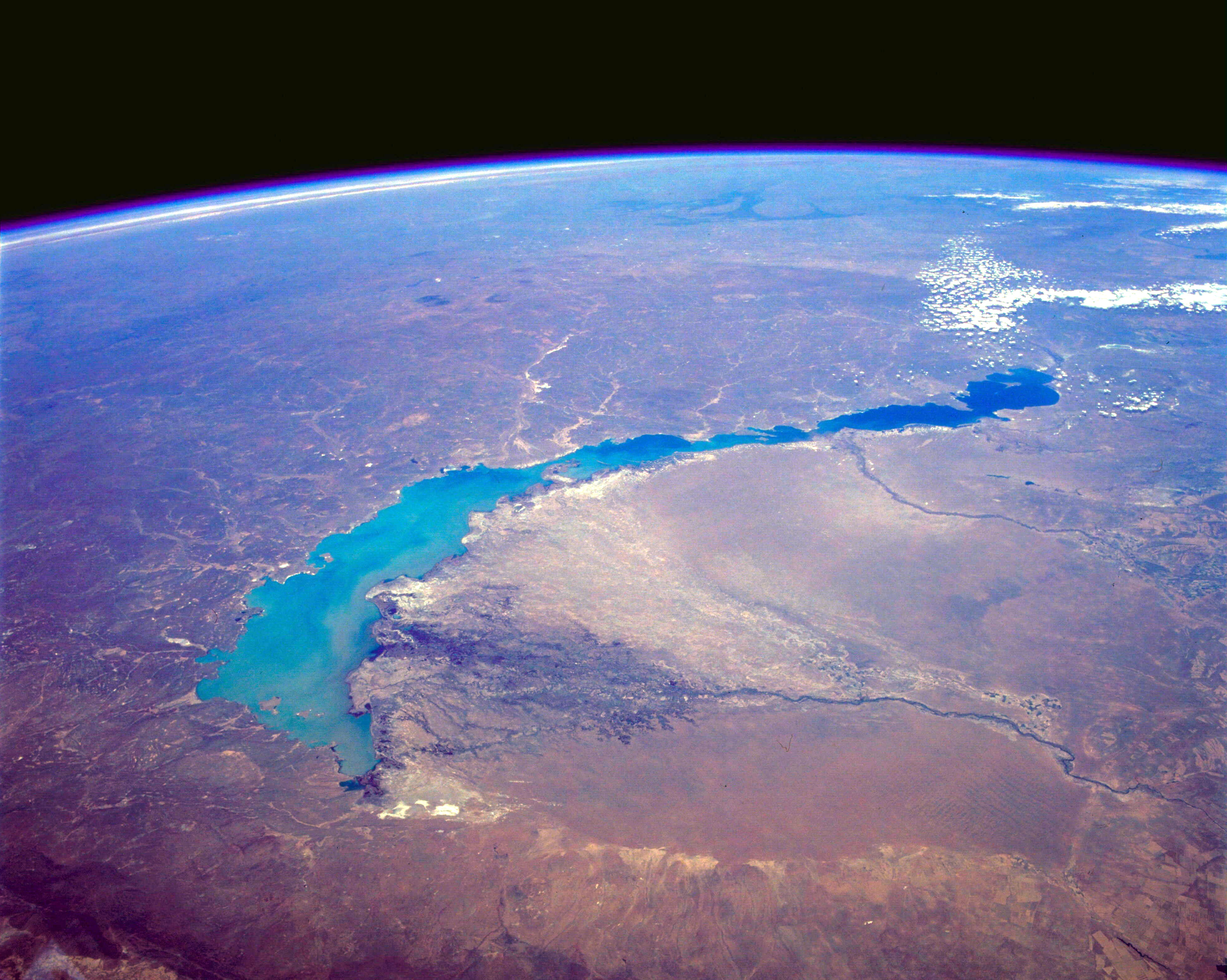
English: STS039-085-00E Lake Balkhash, Kazakhstan April 1991
The turquoise waters of Lake Balkhash can be seen in this northeast-looking, high-oblique photograph. The lake covers 6560 square miles (17 000 square kilometers), is nearly 350 miles (565 kilometers) long, but is only 45 miles (72 kilometers) at its maximum width. The average depth of Lake Balkhash is 20 feet (6 meters), but the lake reaches a maximum depth of 85 feet (26 meters) in its western half. Lake Balkhash extends from the Betpak Steppe in the west to the Kazakh Hills in the northeast. Visible in the photograph to the north of the lake is a vast undulating plain, and south-southeast of the lake are the Ili River and its delta. The Ili River separates two deserts. The larger, sandy Sary-Ishikotrau Desert lies northeast of the Ili River. A much smaller river, the Karatal, traverses this desert and empties into the eastern portion of Lake Balkhash. The Taukum Desert (brownish color) can be seen southwest of the Ili River. A large sandbar or spit (center of the photograph) separates the eastern, shallower, more saline part of Lake Balkhash from the deeper, fresher water of the western portion of the lake. The Ili River is fed by melting snow and glaciers of the Tien Shan ranges in China south of the lake (not visible in the photograph). Lake Balkhash has no river outlet and, even with the influx of fresh water from the Ili River, is shrinking because of evaporation; however, its rate of shrinkage is much less than that of the Aral Sea, which juts into Kazakhstan much farther to the west. |
| Dyddiad | |
| Ffynhonnell | http://eol.jsc.nasa.gov/sseop/EFS/photoinfo.pl?PHOTO=STS039-85-E |
| Awdur | NASA |
Trwyddedu
| This file is in the public domain in the United States because it was solely created by NASA. NASA copyright policy states that "NASA material is not protected by copyright unless noted". (See Template:PD-USGov, NASA copyright policy page or JPL Image Use Policy.) | ||
 |
Warnings:
|
Cofnod lòg yr uwchlwythiad gwreiddiol
Transferred from en.wikipedia to Commons by C messier using CommonsHelper.
The original description page was here. All following user names refer to en.wikipedia.
- 2012-05-29 09:52 Lukemcurley 3948×3153× (1846896 bytes) Cropped some of the black space from the top of the photo to focus on the lake.
- 2012-05-29 09:39 Lukemcurley 3960×4001× (1289732 bytes) Uploading a public-domain item using [[Wikipedia:File_Upload_Wizard|File Upload Wizard]]
Hanes y ffeil
Cliciwch ar ddyddiad / amser i weld y ffeil fel ag yr oedd bryd hynny.
| Dyddiad / Amser | Bawdlun | Hyd a lled | Defnyddiwr | Sylw | |
|---|---|---|---|---|---|
| cyfredol | 03:43, 18 Chwefror 2014 | | 3,948 × 3,153 (1.76 MB) | OgreBot | (BOT): Reverting to most recent version before archival |
| 03:43, 18 Chwefror 2014 |  | 3,960 × 4,001 (1.23 MB) | OgreBot | (BOT): Uploading old version of file from en.wikipedia; originally uploaded on 2012-05-29 09:39:58 by Lukemcurley | |
| 17:12, 16 Chwefror 2014 |  | 3,948 × 3,153 (1.76 MB) | File Upload Bot (Magnus Manske) | Transfered from en.wikipedia by User:C messier using CommonsHelper |
Cysylltiadau'r ffeil
Mae'r 1 tudalennau a ddefnyddir isod yn cysylltu i'r ddelwedd hon:
Defnydd cydwici y ffeil
Mae'r wicis eraill hyn yn defnyddio'r ffeil hon:
- Y defnydd ar ar.wikipedia.org
- Y defnydd ar ast.wikipedia.org
- Y defnydd ar bn.wikipedia.org
- Y defnydd ar br.wikipedia.org
- Y defnydd ar ca.wikipedia.org
- Y defnydd ar el.wikipedia.org
- Y defnydd ar en.wikipedia.org
- Y defnydd ar en.wikiquote.org
- Y defnydd ar eo.wikipedia.org
- Y defnydd ar es.wikipedia.org
- Y defnydd ar eu.wikipedia.org
- Y defnydd ar fi.wikipedia.org
- Y defnydd ar fr.wikipedia.org
- Y defnydd ar gl.wikipedia.org
- Y defnydd ar he.wikipedia.org
- Y defnydd ar id.wikipedia.org
- Y defnydd ar ja.wikipedia.org
- Y defnydd ar kk.wikipedia.org
- Y defnydd ar kn.wikipedia.org
- Y defnydd ar ko.wikipedia.org
- Y defnydd ar lfn.wikipedia.org
- Y defnydd ar mk.wikipedia.org
- Y defnydd ar mr.wikipedia.org
- Y defnydd ar mt.wikipedia.org
- Y defnydd ar nn.wikipedia.org
- Y defnydd ar oc.wikipedia.org
- Y defnydd ar pa.wikipedia.org
- Y defnydd ar pnb.wikipedia.org
- Y defnydd ar simple.wikipedia.org
- Y defnydd ar sl.wikipedia.org
- Y defnydd ar sv.wikipedia.org
- Y defnydd ar sw.wikipedia.org
- Y defnydd ar tg.wikipedia.org
- Y defnydd ar th.wikipedia.org
- Y defnydd ar vi.wikipedia.org
- Y defnydd ar www.wikidata.org
- Y defnydd ar zh-yue.wikipedia.org
- Y defnydd ar zh.wikipedia.org