Delwedd:Saltfleetby National Nature Reserve - geograph.org.uk - 1038303.jpg
Wedi ei chwyddo hyd yr eithaf.
Saltfleetby_National_Nature_Reserve_-_geograph.org.uk_-_1038303.jpg ((640 × 458 picsel, maint y ffeil: 133 KB, ffurf MIME: image/jpeg))
Crynodeb
| Disgrifiad |
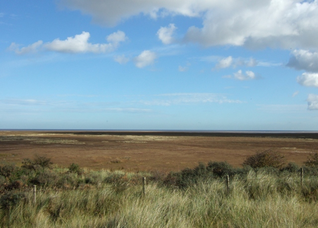
English: Saltfleetby National Nature Reserve Looking out to sea across the reserve from the top of the dunes.
Saltfleetby-Theddlethorpe Dunes NNR is on the Lincolnshire coast, the site comprising about 8 km of coastal dunes and foreshore. The dunes began forming in the 13th century and are reputed to have largely been thrown up in one great storm. The same processes of wind and tidal action continue dune formation on the site today and this is one of those parts of the east coast that is accreting rather than eroding away. The reserve's dunes support a variety of flowers and grasses while saltmarsh and freshwater marsh areas are home to a wide variety of insects, amphibians, birds and mammals. |
| Dyddiad | |
| Ffynhonnell | From geograph.org.uk |
| Awdur | Simon Huguet |
| Cydnabyddiaeth (required by the license) | Simon Huguet / Saltfleetby National Nature Reserve / |
| Camera location | | View this and other nearby images on: OpenStreetMap |
|---|
_heading:90.00&language=cy)
| Object location | | View this and other nearby images on: OpenStreetMap |
|---|
_heading:90.00&language=cy)
Trwyddedu

|
This image was taken from the Geograph project collection. See this photograph's page on the Geograph website for the photographer's contact details. The copyright on this image is owned by Simon Huguet and is licensed for reuse under the Creative Commons Attribution-ShareAlike 2.0 license.
|
Trwyddedir y ffeil hon yn ôl termau'r drwydded Creative Commons Attribution-Share Alike 2.0 Generic.
Cydnabyddiaeth: Simon Huguet
- Mae'n rhydd i chi:
- rhannu – gallwch gopïo, dosbarthu a throsglwyddo'r gwaith
- ailwampio – gallwch addasu'r gwaith
- Ar yr amodau canlynol:
- cydnabyddiaeth – Mae'n rhaid i chi nodi manylion y gwaith hwn, rhoi dolen i'r drwydded, a nodi os y bu golygu arni, yn y modd a benwyd gan yr awdur neu'r trwyddedwr (ond heb awgrymu o gwbl eu bod yn eich cymeradwyo chi na'ch defnydd o'r gwaith).
- rhannu ar dermau tebyg – Os byddwch yn addasu'r gwaith hwn, neu yn ei drawsnewid, neu yn adeiladu arno, mae'n rhaid i chi ddosbarthu'r gwaith dan drwydded sy'n union yr un fath same a'r gwreiddiol.
Hanes y ffeil
Cliciwch ar ddyddiad / amser i weld y ffeil fel ag yr oedd bryd hynny.
| Dyddiad / Amser | Bawdlun | Hyd a lled | Defnyddiwr | Sylw | |
|---|---|---|---|---|---|
| cyfredol | 18:54, 23 Chwefror 2011 | | 640 × 458 (133 KB) | GeographBot | == {{int:filedesc}} == {{Information |description={{en|1=Saltfleetby National Nature Reserve Looking out to sea across the reserve from the top of the dunes. Saltfleetby-Theddlethorpe Dunes NNR is on the Lincolnshire coast, the site comprising about 8 km |
Cysylltiadau'r ffeil
Mae'r 1 tudalennau a ddefnyddir isod yn cysylltu i'r ddelwedd hon:
Defnydd cydwici y ffeil
Mae'r wicis eraill hyn yn defnyddio'r ffeil hon:
- Y defnydd ar ceb.wikipedia.org
- Y defnydd ar en.wikipedia.org
- Y defnydd ar fr.wikipedia.org
- Y defnydd ar pl.wikipedia.org
- Y defnydd ar tr.wikipedia.org
- Y defnydd ar www.wikidata.org