Delwedd:San Andreas Fault Aerial View.gif
Wedi ei chwyddo hyd yr eithaf.
San_Andreas_Fault_Aerial_View.gif ((300 × 439 picsel, maint y ffeil: 82 KB, ffurf MIME: image/gif))
| Disgrifiad |
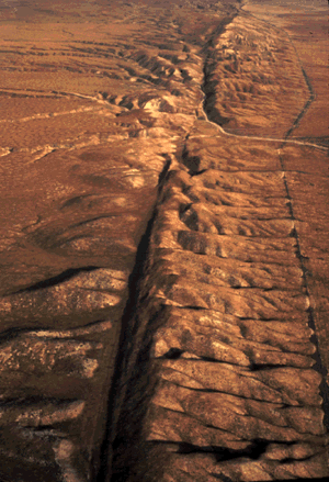
English: An aerial view of the San Andreas Fault in the Carrizo Plain, Central California |
| Dyddiad | eergister ofzo |
| Ffynhonnell | http://pubs.usgs.gov/gip/earthq1/how.html |
| Awdur | USGS |
| Caniatâd (Ailddefnyddio'r ffeil hon) |
PD |
This image is in the public domain in the United States because it only contains materials that originally came from the United States Geological Survey, an agency of the United States Department of the Interior. For more information, see the official USGS copyright policy.
|
Hanes y ffeil
Cliciwch ar ddyddiad / amser i weld y ffeil fel ag yr oedd bryd hynny.
| Dyddiad / Amser | Bawdlun | Hyd a lled | Defnyddiwr | Sylw | |
|---|---|---|---|---|---|
| cyfredol | 15:30, 26 Gorffennaf 2006 | | 300 × 439 (82 KB) | Cave cattum | {{Information| |Description = An aerial view of the San Andreas fault in the Carrizo Plain, Central California |Source = http://pubs.usgs.gov/gip/earthq1/how.html |Date = |Author = USGS |Permission = PD |other_versions = }} {{PD-USGov-Interior-USGS}} [[ |
Cysylltiadau'r ffeil
Mae'r 1 tudalennau a ddefnyddir isod yn cysylltu i'r ddelwedd hon:
Defnydd cydwici y ffeil
Mae'r wicis eraill hyn yn defnyddio'r ffeil hon:
- Y defnydd ar ar.wikipedia.org
- Y defnydd ar ast.wikipedia.org
- Y defnydd ar ca.wikipedia.org
- Y defnydd ar cs.wikipedia.org
- Y defnydd ar cs.wikiversity.org
- Y defnydd ar de.wikipedia.org
- Y defnydd ar en.wikipedia.org
- Y defnydd ar en.wikiversity.org
- Y defnydd ar fr.wikipedia.org
- Y defnydd ar fr.wiktionary.org
- Y defnydd ar ga.wikipedia.org
- Y defnydd ar he.wikipedia.org
- העתק
- העתק סן אנדראס
- פורטל:גאולוגיה/הידעת?/קטעי הידעת
- תבנית:הידעת? 13 ביולי - סדרה 1
- פורטל:ספורט/הידעת?/קטעי הידעת
- ויקיפדיה:הידעת?/דיונים/מיזם היובל/הצבעה
- פורטל:גאולוגיה/הרכב ותכונות/תכונות נבחרות
- פורטל:גאולוגיה/מבנה ותכונות/11
- קמט (גאולוגיה)
- תבנית:הידעת? 13 ביולי 2012
- ויקיפדיה:הידעת?/2012/יולי
- ויקיפדיה:הידעת?/2015/יולי
- תבנית:הידעת? 15 ביולי 2015
- ויקיפדיה:הידעת?/2017/יולי
- תבנית:הידעת? 18 ביולי 2017
- התצפית העמוקה של שבר סן אנדראס
- תבנית:הידעת? 10 ביולי 2020
- ויקיפדיה:הידעת?/2020/יולי
- פורטל:ארצות הברית/הידעת?/קטעי הידעת? - 2
- פורטל:ארצות הברית/הידעת?/108
- פורטל:ספורט/הידעת?/61
- פורטל:משחקים/הידעת?/אוסף
- פורטל:משחקים/הידעת?/20
- פורטל:גאולוגיה/הידעת?/25
- ויקיפדיה:הידעת?/2022/יולי
- תבנית:הידעת? 13 ביולי 2022
- Y defnydd ar hi.wikipedia.org
- Y defnydd ar hu.wikipedia.org
- Y defnydd ar id.wikipedia.org
- Y defnydd ar it.wikipedia.org
- Y defnydd ar ja.wikipedia.org
Gweld rhagor o'r defnydd cydwici o'r ffeil hon.