Delwedd:Scotland sections of Munro's tables.png

Maint y rhagolwg: 433 × 599 picsel. Eglurdebau eraill: 173 × 240 picsel | 347 × 480 picsel | 555 × 768 picsel | 740 × 1,024 picsel | 2,109 × 2,916 picsel.
Maint llawn ((2,109 × 2,916 picsel, maint y ffeil: 341 KB, ffurf MIME: image/png))
Crynodeb
| Disgrifiad |
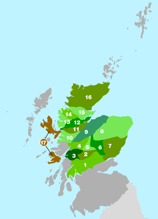
English: Rough outline of the areas used in Munro's 1891 tables to divide up the mountain ranges of Scotland. Map based on information in the 2006 edition of The Munros - SMC Hillwalkers' Guide ISBN 0907521940 |
| Ffynhonnell | Gwaith yr uwchlwythwr |
| Awdur | Cnbrb |
Trwyddedu
| Yr wyf fi, deiliad hawlfraint y gwaith hwn, yn ei ryddhau i'r parth cyhoeddus, a hynny'n fyd-eang. Hwyrach nad yw hyn yn bosib yn ôl cyfraith rhai gwledydd; os felly: Rwyn rhoi i unrhywun yr hawl i ddefnyddio'r gwaith hwn at unrhyw ddiben, heb unrhyw amodau, oddieithr unrhyw amodau gofynnol yn ôl y gyfraith. |
Hanes y ffeil
Cliciwch ar ddyddiad / amser i weld y ffeil fel ag yr oedd bryd hynny.
| Dyddiad / Amser | Bawdlun | Hyd a lled | Defnyddiwr | Sylw | |
|---|---|---|---|---|---|
| cyfredol | 21:54, 26 Gorffennaf 2008 | | 2,109 × 2,916 (341 KB) | Cnbrb | {{Information |Description= English: English: Rough outline of the areas used in Munro's 1891 tables to divide up the mountain ranges of Scotland. Map based on information in the 2006 edition of The Munros - SMC Hillwalkers' Guide ISBN 0907521940 |Source |
| 20:00, 27 Mehefin 2008 |  | 600 × 828 (75 KB) | Cnbrb | {{Information |Description={{en|1=English: Rough outline of the areas used in Munro's 1891 tables to divide up the mountain ranges of Scotland. Map based on information in the 2006 edition of '''The Munros - SMC Hillwalkers' Guide''' ISBN 0907521940}} |So |
Cysylltiadau'r ffeil
Mae'r 1 tudalennau a ddefnyddir isod yn cysylltu i'r ddelwedd hon:
Defnydd cydwici y ffeil
Mae'r wicis eraill hyn yn defnyddio'r ffeil hon:
- Y defnydd ar bg.wikipedia.org
- Y defnydd ar de.wikipedia.org
- Y defnydd ar en.wikipedia.org
- Y defnydd ar es.wikipedia.org
- Y defnydd ar eu.wikipedia.org
- Y defnydd ar ga.wikipedia.org
- Y defnydd ar it.wikipedia.org
- Y defnydd ar nl.wikipedia.org
- Y defnydd ar nn.wikipedia.org
- Y defnydd ar no.wikipedia.org
- Y defnydd ar www.wikidata.org