Delwedd:StLuciaWetland L7 07may01.jpg
Wedi ei chwyddo hyd yr eithaf.
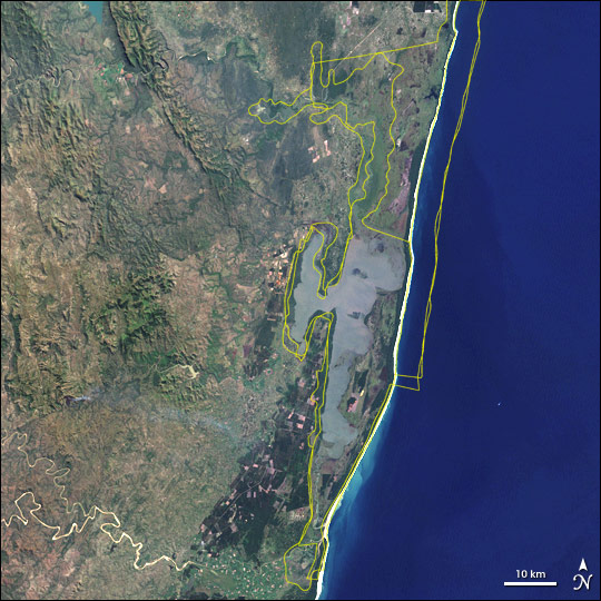
StLuciaWetland_L7_07may01.jpg ((540 × 540 picsel, maint y ffeil: 102 KB, ffurf MIME: image/jpeg))
Crynodeb
| Disgrifiad | Satellite image of w:Greater St. Lucia Wetland Park, South Africa. Borders of the various conservation areas in the park are outlined in yellow. |
| Dyddiad | |
| Ffynhonnell | http://earthobservatory.nasa.gov/Newsroom/NewImages/images.php3?img_id=16722 |
| Awdur | Jesse Allen, NASA Earth Observatory, using Landsat and GIS data obtained from the University of Maryland’s Global Land Cover Facility. |
| Caniatâd (Ailddefnyddio'r ffeil hon) |
Public domain |
| Diwygiadau eraill | Larger, uncropped version available from source URL (sans borders). |
Trwyddedu
| This file is in the public domain in the United States because it was solely created by NASA. NASA copyright policy states that "NASA material is not protected by copyright unless noted". (See Template:PD-USGov, NASA copyright policy page or JPL Image Use Policy.) | ||
 |
Warnings:
|
Hanes y ffeil
Cliciwch ar ddyddiad / amser i weld y ffeil fel ag yr oedd bryd hynny.
| Dyddiad / Amser | Bawdlun | Hyd a lled | Defnyddiwr | Sylw | |
|---|---|---|---|---|---|
| cyfredol | 16:10, 19 Mai 2006 | | 540 × 540 (102 KB) | Holly Cheng | {{Information | Description=Satellite image of w:Greater St. Lucia Wetland Park, South Africa. Borders of the various conservation areas in the park are outlined in yellow. | Source=http://earthobservatory.nasa.gov/Newsroom/NewImages/images.php3?img_i |
Cysylltiadau'r ffeil
Mae'r 1 tudalennau a ddefnyddir isod yn cysylltu i'r ddelwedd hon:
Defnydd cydwici y ffeil
Mae'r wicis eraill hyn yn defnyddio'r ffeil hon:
- Y defnydd ar af.wikipedia.org
- Y defnydd ar ar.wikipedia.org
- Y defnydd ar ast.wikipedia.org
- Y defnydd ar avk.wikipedia.org
- Y defnydd ar az.wikipedia.org
- Y defnydd ar ca.wikipedia.org
- Y defnydd ar cs.wikipedia.org
- Y defnydd ar cv.wikipedia.org
- Y defnydd ar de.wikipedia.org
- Y defnydd ar de.wikivoyage.org
- Y defnydd ar en.wikipedia.org
- Y defnydd ar eo.wikipedia.org
- Y defnydd ar es.wikipedia.org
- Y defnydd ar fi.wikipedia.org
- Y defnydd ar fr.wikipedia.org
- Y defnydd ar fr.wikivoyage.org
- Y defnydd ar gl.wikipedia.org
- Y defnydd ar he.wikipedia.org
- Y defnydd ar hr.wikipedia.org
- Y defnydd ar hu.wikipedia.org
- Y defnydd ar hy.wikipedia.org
- Y defnydd ar is.wikipedia.org
- Y defnydd ar it.wikipedia.org
- Y defnydd ar ja.wikipedia.org
- Y defnydd ar ka.wikipedia.org
- Y defnydd ar lv.wikipedia.org
- Y defnydd ar mt.wikipedia.org
- Y defnydd ar no.wikipedia.org
- Y defnydd ar oc.wikipedia.org
- Y defnydd ar pl.wikipedia.org
- Y defnydd ar ru.wikipedia.org
- Y defnydd ar sh.wikipedia.org
- Y defnydd ar sk.wikipedia.org
- Y defnydd ar sr.wikipedia.org
- Y defnydd ar uk.wikipedia.org
- Y defnydd ar vec.wikipedia.org
- Y defnydd ar vi.wikipedia.org
- Y defnydd ar www.wikidata.org
Gweld rhagor o'r defnydd cydwici o'r ffeil hon.