Delwedd:St Decuman's, Rhoscrowther - geograph.org.uk - 1338416.jpg
Wedi ei chwyddo hyd yr eithaf.
St_Decuman's,_Rhoscrowther_-_geograph.org.uk_-_1338416.jpg ((640 × 480 picsel, maint y ffeil: 57 KB, ffurf MIME: image/jpeg))
|
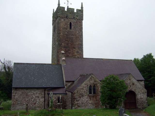
Dyma lun o adeilad rhestredig rhif 6591. |
Crynodeb
| Disgrifiad |
English: St Decuman's, Rhoscrowther A large cruciform mediaeval church which now stands alone, almost the sole survivor of the deserted village of Rhoscrowther.
Supposedly founded by St Decuman(us) or Degman, an early Christian saint who was born here and crossed the Severn in a coracle to Somerset where, in Watchet, is the only other church dedicated to him. It is thought that his cell that once formed part of the church; there is also St Degman's well not far away. The earliest parts of the church go back to C13/14. It was restored twice in the C19 and again in 1910. Services are still held for the exiled villagers. |
| Dyddiad | |
| Ffynhonnell | From geograph.org.uk |
| Awdur | ceridwen |
| Cydnabyddiaeth (required by the license) | ceridwen / St Decuman's, Rhoscrowther / |
| Camera location | | View this and other nearby images on: OpenStreetMap |
|---|
_heading:180.00&language=cy)
| Object location | | View this and other nearby images on: OpenStreetMap |
|---|
_heading:180.00&language=cy)
Trwyddedu

|
This image was taken from the Geograph project collection. See this photograph's page on the Geograph website for the photographer's contact details. The copyright on this image is owned by ceridwen and is licensed for reuse under the Creative Commons Attribution-ShareAlike 2.0 license.
|
Trwyddedir y ffeil hon yn ôl termau'r drwydded Creative Commons Attribution-Share Alike 2.0 Generic.
Cydnabyddiaeth: ceridwen
- Mae'n rhydd i chi:
- rhannu – gallwch gopïo, dosbarthu a throsglwyddo'r gwaith
- ailwampio – gallwch addasu'r gwaith
- Ar yr amodau canlynol:
- cydnabyddiaeth – Mae'n rhaid i chi nodi manylion y gwaith hwn, rhoi dolen i'r drwydded, a nodi os y bu golygu arni, yn y modd a benwyd gan yr awdur neu'r trwyddedwr (ond heb awgrymu o gwbl eu bod yn eich cymeradwyo chi na'ch defnydd o'r gwaith).
- rhannu ar dermau tebyg – Os byddwch yn addasu'r gwaith hwn, neu yn ei drawsnewid, neu yn adeiladu arno, mae'n rhaid i chi ddosbarthu'r gwaith dan drwydded sy'n union yr un fath same a'r gwreiddiol.
Hanes y ffeil
Cliciwch ar ddyddiad / amser i weld y ffeil fel ag yr oedd bryd hynny.
| Dyddiad / Amser | Bawdlun | Hyd a lled | Defnyddiwr | Sylw | |
|---|---|---|---|---|---|
| cyfredol | 02:22, 28 Chwefror 2011 | | 640 × 480 (57 KB) | GeographBot | == {{int:filedesc}} == {{Information |description={{en|1=St Decuman's, Rhoscrowther A large cruciform mediaeval church which now stands alone, almost the sole suvivor of the deserted village of Rhoscrowther. Supposedly founded by St Decuman(us) or Degman |
Cysylltiadau'r ffeil
Mae'r 1 tudalennau a ddefnyddir isod yn cysylltu i'r ddelwedd hon:
Defnydd cydwici y ffeil
Mae'r wicis eraill hyn yn defnyddio'r ffeil hon:
- Y defnydd ar arz.wikipedia.org
- Y defnydd ar br.wikipedia.org
- Y defnydd ar en.wikipedia.org
- Y defnydd ar www.wikidata.org