Delwedd:The Blaen-y-cwm mill from the internal tramway leading to the top of the Blaen-y-Cwm pit. - geograph.org.uk - 596449.jpg
Wedi ei chwyddo hyd yr eithaf.
The_Blaen-y-cwm_mill_from_the_internal_tramway_leading_to_the_top_of_the_Blaen-y-Cwm_pit._-_geograph.org.uk_-_596449.jpg ((640 × 396 picsel, maint y ffeil: 96 KB, ffurf MIME: image/jpeg))
Crynodeb
| Disgrifiad |
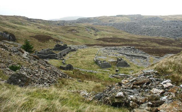
English: The Blaen-y-cwm mill from the internal tramway leading to the top of the Blaen-y-Cwm pit. This tramway was linked to the floor of the pit by an uphauling incline. Quarried rock from the pit (and prior to the untopping from the underground workings) was transported along the tramway to the Blaen-y-Cwm exit incline and down hauled to the mill.Finished slate would then be uphauled to the Rhiwbach Tramroad. |
| Dyddiad | |
| Ffynhonnell | From geograph.org.uk |
| Awdur | Eric Jones |
| Cydnabyddiaeth (required by the license) | Eric Jones / The Blaen-y-cwm mill from the internal tramway leading to the top of the Blaen-y-Cwm pit. / |
| Camera location | | View this and other nearby images on: OpenStreetMap |
|---|
_heading:337.00&language=cy)
| Object location | | View this and other nearby images on: OpenStreetMap |
|---|
_heading:337.00&language=cy)
Trwyddedu

|
This image was taken from the Geograph project collection. See this photograph's page on the Geograph website for the photographer's contact details. The copyright on this image is owned by Eric Jones and is licensed for reuse under the Creative Commons Attribution-ShareAlike 2.0 license.
|
Trwyddedir y ffeil hon yn ôl termau'r drwydded Creative Commons Attribution-Share Alike 2.0 Generic.
Cydnabyddiaeth: Eric Jones
- Mae'n rhydd i chi:
- rhannu – gallwch gopïo, dosbarthu a throsglwyddo'r gwaith
- ailwampio – gallwch addasu'r gwaith
- Ar yr amodau canlynol:
- cydnabyddiaeth – Mae'n rhaid i chi nodi manylion y gwaith hwn, rhoi dolen i'r drwydded, a nodi os y bu golygu arni, yn y modd a benwyd gan yr awdur neu'r trwyddedwr (ond heb awgrymu o gwbl eu bod yn eich cymeradwyo chi na'ch defnydd o'r gwaith).
- rhannu ar dermau tebyg – Os byddwch yn addasu'r gwaith hwn, neu yn ei drawsnewid, neu yn adeiladu arno, mae'n rhaid i chi ddosbarthu'r gwaith dan drwydded sy'n union yr un fath same a'r gwreiddiol.
Hanes y ffeil
Cliciwch ar ddyddiad / amser i weld y ffeil fel ag yr oedd bryd hynny.
| Dyddiad / Amser | Bawdlun | Hyd a lled | Defnyddiwr | Sylw | |
|---|---|---|---|---|---|
| cyfredol | 20:44, 6 Chwefror 2011 | | 640 × 396 (96 KB) | GeographBot | == {{int:filedesc}} == {{Information |description={{en|1=The Blaen-y-cwm mill from the internal tramway leading to the top of the Blaen-y-Cwm pit. This tramway was linked to the floor of the pit by an uphauling incline. Quarried rock from the pit (and pri |
Cysylltiadau'r ffeil
Mae'r 1 tudalennau a ddefnyddir isod yn cysylltu i'r ddelwedd hon:
Defnydd cydwici y ffeil
Mae'r wicis eraill hyn yn defnyddio'r ffeil hon:
- Y defnydd ar en.wikipedia.org
- Y defnydd ar www.wikidata.org