Delwedd:Thornapple TIGER Irving dam area map3c.PNG
Thornapple_TIGER_Irving_dam_area_map3c.PNG ((422 × 359 picsel, maint y ffeil: 7 KB, ffurf MIME: image/png))
Daw'r ffeil hon o Comin Wikimedia a gellir ei defnyddio gan brosiectau eraill. Dangosir isod y disgrifiad sydd ar dudalen ddisgrifio'r ffeil yno.
Crynodeb

|
File:Thornapple TIGER Irving dam area map3c.svg is a vector version of this file. It should be used in place of this PNG file.
File:Thornapple TIGER Irving dam area map3c.PNG → File:Thornapple TIGER Irving dam area map3c.svg
For more information, see Help:SVG.
|
| Camera location | 42° 41′ 28.21″ N, 85° 24′ 57.1″ W | View this and other nearby images on: OpenStreetMap |
|---|
| DisgrifiadThornapple TIGER Irving dam area map3c.PNG |
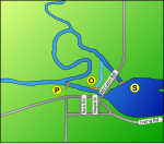
A map of the area of the Irving Dam in Irving, Michigan on the Thornapple River. The Irving dam is actually three different structures, which are labeled on the map as follows:
This map is modified from a USGS/USCB TIGER generated map - link to original map This TerraServer-USA topographical map shows the area clearly as well. Google maps are lacking in detail in this area. |
| Dyddiad | Generated on January 13, 2007 |
| Ffynhonnell | US gov |
| Awdur | Generated by User:Lar (w:en:User:Lar) using US Government provided TIGER tool |
| Caniatâd (Ailddefnyddio'r ffeil hon) |
PD US Government - TIGER is a service of the United States Census Bureau, and therefore the base image, like all TIGER images, is in the public domain. This derived image is Dual licensed under GFDL and Creative Commons Attribution 2.5 (CC-BY 2.5) |
| Diwygiadau eraill |
pictures of the dams are available for review at this Maj.com gallery. contact uploader who will happily upload additional ones. Note: Other versions of this drawing are available on request. (for example, without the letters) At this time, no SVG version is available (see below, one has been requested by inclusion of the {{Convert to SVG}}) template). In the event one is created, a crosslink will be added if notified. If you are interested in creating an SVG, contact the uploader, who may be able to suggest additional resources to improve the image from what is shown here. |
Trwyddedu

|
Caniateir copïo, dosbarthu a/neu golygu'r ddogfen hon yn ôl telerau'r Drwydded Ddogfennaeth Rydd GNU, Fersiwn 1.2 neu unrhyw fersiwn diweddarach a gyhoeddwyd gan y Free Software Foundation; yn cynnwys dim Adrannau Di-syfl, dim Testunau Clawr Blaen, a dim Testunau Clawr Cefn. Cynhwysir copi o'r drwydded hon yn yr adran Trwydded Ddogfennaeth Rydd GNU".http://www.gnu.org/copyleft/fdl.htmlGFDLGNU Free Documentation Licensetruetrue |
| Trwyddedir y ffeil hon yn ôl termau'r drwydded Creative Commons Attribution-Share Alike 3.0 Unported. | ||
| ||
| Ychwangwyd y nod trwyddedu hwn wrth y ffeil hon yn ran o'r gwaith o ddiweddaru trwyddedau GFDL.http://creativecommons.org/licenses/by-sa/3.0/CC BY-SA 3.0Creative Commons Attribution-Share Alike 3.0truetrue |
- Mae'n rhydd i chi:
- rhannu – gallwch gopïo, dosbarthu a throsglwyddo'r gwaith
- ailwampio – gallwch addasu'r gwaith
- Ar yr amodau canlynol:
- cydnabyddiaeth – Mae'n rhaid i chi nodi manylion y gwaith hwn, rhoi dolen i'r drwydded, a nodi os y bu golygu arni, yn y modd a benwyd gan yr awdur neu'r trwyddedwr (ond heb awgrymu o gwbl eu bod yn eich cymeradwyo chi na'ch defnydd o'r gwaith).
Captions
Items portrayed in this file
yn portreadu
coordinates of the point of view Saesneg
42°41'28.21"N, 85°24'57.10"W
Hanes y ffeil
Cliciwch ar ddyddiad / amser i weld y ffeil fel ag yr oedd bryd hynny.
| Dyddiad / Amser | Bawdlun | Hyd a lled | Defnyddiwr | Sylw | |
|---|---|---|---|---|---|
| cyfredol | 01:10, 14 Ionawr 2007 |  | 422 × 359 (7 KB) | Lar | {{Location dec US|.90835|-85.49891}} {{Information |Description=A map of the area of the Irving Dam in Irving, Michigan on the Thornapple River. The Irving dam is actually three different stru |
Cysylltiadau'r ffeil
Nid oes tudalennau'n defnyddio'r ffeil hon.
