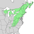
Delwedd:Tsuga canadensis range map 1.png

Maint y rhagolwg: 600 × 600 picsel. Eglurdebau eraill: 240 × 240 picsel | 480 × 480 picsel | 768 × 768 picsel | 1,024 × 1,024 picsel | 2,048 × 2,048 picsel | 7,403 × 7,403 picsel.
Maint llawn ((7,403 × 7,403 picsel, maint y ffeil: 767 KB, ffurf MIME: image/png))
Hanes y ffeil
Cliciwch ar ddyddiad / amser i weld y ffeil fel ag yr oedd bryd hynny.
| Dyddiad / Amser | Bawdlun | Hyd a lled | Defnyddiwr | Sylw | |
|---|---|---|---|---|---|
| cyfredol | 00:29, 6 Ionawr 2014 |  | 7,403 × 7,403 (767 KB) | Nonenmac | wider range, province borders |
| 03:36, 29 Hydref 2013 |  | 3,456 × 3,456 (192 KB) | Nonenmac | User created page with UploadWizard |
Cysylltiadau'r ffeil
Mae'r 1 tudalennau a ddefnyddir isod yn cysylltu i'r ddelwedd hon:
Defnydd cydwici y ffeil
Mae'r wicis eraill hyn yn defnyddio'r ffeil hon:
- Y defnydd ar arz.wikipedia.org
- Y defnydd ar ceb.wikipedia.org
- Y defnydd ar cs.wikipedia.org
- Y defnydd ar en.wikipedia.org
- Y defnydd ar eu.wikipedia.org
- Y defnydd ar is.wikipedia.org
- Y defnydd ar ro.wikipedia.org
- Y defnydd ar sv.wikipedia.org
- Y defnydd ar uk.wikipedia.org
- Y defnydd ar www.wikidata.org
