Delwedd:Wallace-line1.jpg
Maint y rhagolwg: 800 × 503 picsel. Eglurdebau eraill: 320 × 201 picsel | 640 × 403 picsel | 1,024 × 644 picsel | 1,280 × 805 picsel | 2,560 × 1,610 picsel | 3,685 × 2,318 picsel.
Maint llawn ((3,685 × 2,318 picsel, maint y ffeil: 3.6 MB, ffurf MIME: image/jpeg))
Crynodeb
| Disgrifiad |
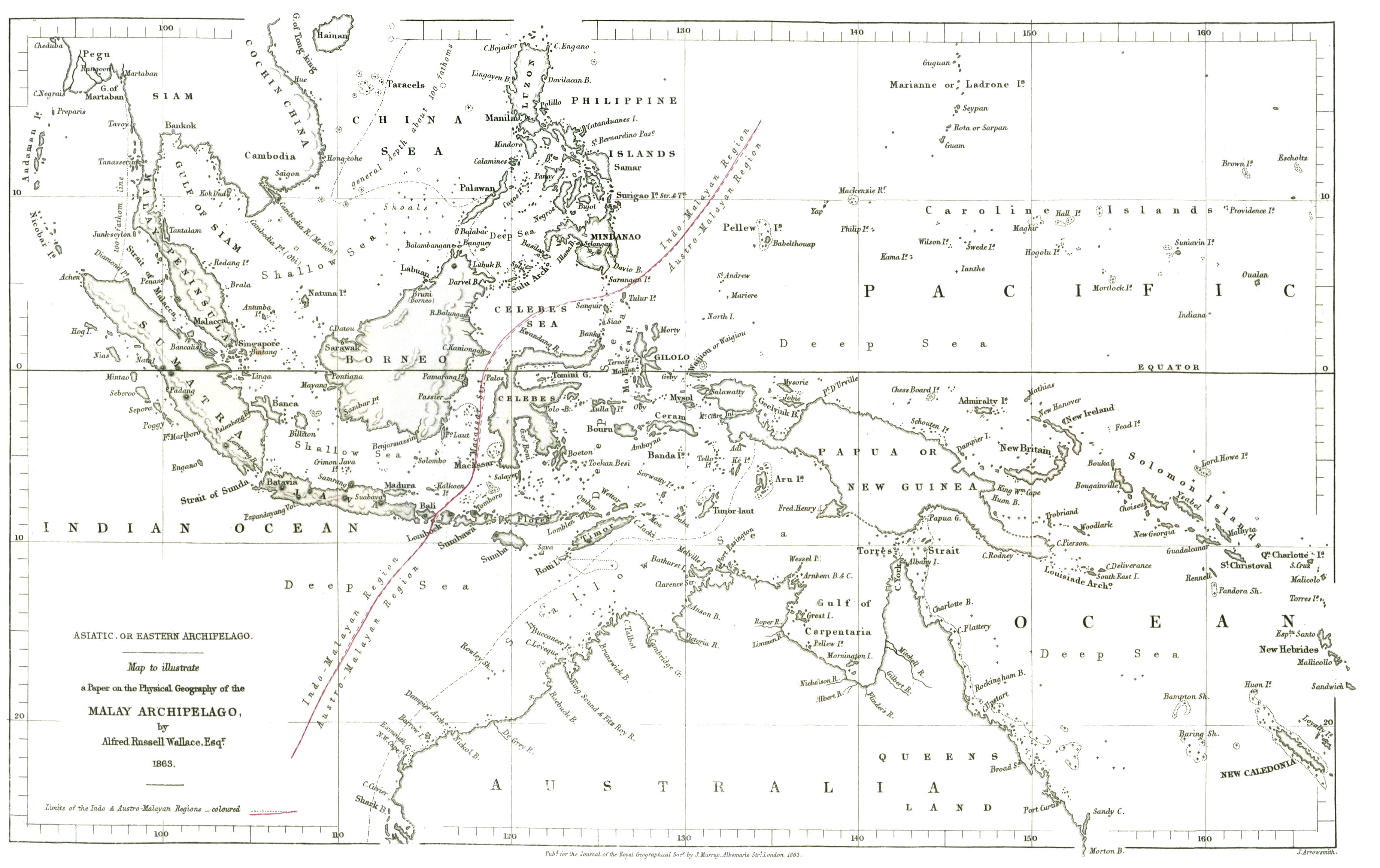
English: The original drawing of the 'Wallace Line' showing the division between Asian and Australasian flora and fauna reproduced at the internet archive |
|||||||||
| Dyddiad | ||||||||||
| Ffynhonnell | On the Physical Geography of the Malay Archipelago | |||||||||
| Crëwr |
Wallace, Alfred Russel; J. Arrowsmith |
|||||||||
| Geotemporal data | ||||||||||
| Bounding box |
|
|||||||||
| Georeferencing | ||||||||||
Trwyddedu
|
This work is in the public domain in its country of origin and other countries and areas where the copyright term is the author's life plus 70 years or fewer. This work is in the public domain in the United States because it was published (or registered with the U.S. Copyright Office) before January 1, 1929. | |
| Canfyddwyd bod y ffeil yn rhydd o gyfyngiadau yn ôl cyfraith hawlfraint, gan gynnwys pob hawl perthynol a chyfagos. | |
Hanes y ffeil
Cliciwch ar ddyddiad / amser i weld y ffeil fel ag yr oedd bryd hynny.
| Dyddiad / Amser | Bawdlun | Hyd a lled | Defnyddiwr | Sylw | |
|---|---|---|---|---|---|
| cyfredol | 01:41, 23 Mawrth 2022 | | 3,685 × 2,318 (3.6 MB) | Shyamal | Reduce whitespace on the right Cropped 12 % horizontally using CropTool with precise mode. |
| 05:25, 26 Awst 2018 |  | 4,208 × 2,318 (3.4 MB) | Shyamal | Keep the colors | |
| 08:33, 19 Ebrill 2018 |  | 3,632 × 2,280 (1.84 MB) | Shyamal | Complete map | |
| 08:26, 19 Ebrill 2018 |  | 2,100 × 2,298 (1.28 MB) | Shyamal | Boost contrast | |
| 09:51, 25 Ebrill 2015 |  | 2,100 × 2,298 (515 KB) | Chris55 | User created page with UploadWizard |
Cysylltiadau'r ffeil
Mae'r 1 tudalennau a ddefnyddir isod yn cysylltu i'r ddelwedd hon:
Defnydd cydwici y ffeil
Mae'r wicis eraill hyn yn defnyddio'r ffeil hon:
- Y defnydd ar bg.wikipedia.org
- Y defnydd ar en.wikipedia.org
- Y defnydd ar fa.wikipedia.org
- Y defnydd ar gl.wikipedia.org
- Y defnydd ar hy.wikipedia.org
- Y defnydd ar it.wikipedia.org
- Y defnydd ar pt.wikipedia.org
- Y defnydd ar ta.wikipedia.org
- Y defnydd ar www.wikidata.org