Delwedd:Wallis and Futuna-CIA WFB Map.png
Wedi ei chwyddo hyd yr eithaf.
Wallis_and_Futuna-CIA_WFB_Map.png ((330 × 354 picsel, maint y ffeil: 3 KB, ffurf MIME: image/png))

|
This map image could be re-created using vector graphics as an SVG file. This has several advantages; see Commons:Media for cleanup for more information. If an SVG form of this image is available, please upload it and afterwards replace this template with
{{vector version available|new image name}}.
It is recommended to name the SVG file “Wallis and Futuna-CIA WFB Map.svg”—then the template Vector version available (or Vva) does not need the new image name parameter. |
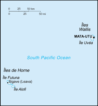
| Disgrifiad |
English: Map of Wallis and Futuna, showing islands and towns. |
|||
| Dyddiad | ||||
| Ffynhonnell | CIA, The World Factbook, 2004 (internet version) | |||
| Awdur | CIA | |||
| Caniatâd (Ailddefnyddio'r ffeil hon) |
|
|||
| Diwygiadau eraill | Macedonian version |

Hanes y ffeil
Cliciwch ar ddyddiad / amser i weld y ffeil fel ag yr oedd bryd hynny.
| Dyddiad / Amser | Bawdlun | Hyd a lled | Defnyddiwr | Sylw | |
|---|---|---|---|---|---|
| cyfredol | 09:18, 27 Mawrth 2005 | | 330 × 354 (3 KB) | Wolfman~commonswiki | {{CIA-map}} |
Cysylltiadau'r ffeil
Nid oes tudalennau'n defnyddio'r ffeil hon.
Defnydd cydwici y ffeil
Mae'r wicis eraill hyn yn defnyddio'r ffeil hon:
- Y defnydd ar az.wikipedia.org
- Y defnydd ar be-tarask.wikipedia.org
- Y defnydd ar cs.wikipedia.org
- Y defnydd ar el.wikipedia.org
- Y defnydd ar en.wikipedia.org
- Y defnydd ar en.wikisource.org
- Y defnydd ar es.wikipedia.org
- Y defnydd ar eu.wikipedia.org
- Y defnydd ar fa.wikipedia.org
- Y defnydd ar fi.wikipedia.org
- Y defnydd ar gl.wikipedia.org
- Y defnydd ar hy.wikipedia.org
- Y defnydd ar id.wikipedia.org
- Y defnydd ar incubator.wikimedia.org
- Y defnydd ar it.wikipedia.org
- Y defnydd ar ja.wikipedia.org
- Y defnydd ar ka.wikipedia.org
- Y defnydd ar mr.wikipedia.org
- Y defnydd ar pl.wikipedia.org
- Y defnydd ar pt.wikipedia.org
- Y defnydd ar pt.wikivoyage.org
- Y defnydd ar to.wikipedia.org
- Y defnydd ar uk.wikipedia.org
- Y defnydd ar vi.wikipedia.org
- Y defnydd ar zh.wikipedia.org