Delwedd:Watersnoodramp 1953.jpg
Maint y rhagolwg: 746 × 600 picsel. Eglurdebau eraill: 299 × 240 picsel | 597 × 480 picsel | 955 × 768 picsel | 1,274 × 1,024 picsel | 2,548 × 2,048 picsel | 2,943 × 2,366 picsel.
Maint llawn ((2,943 × 2,366 picsel, maint y ffeil: 1.94 MB, ffurf MIME: image/jpeg))
Crynodeb
| Disgrifiad |
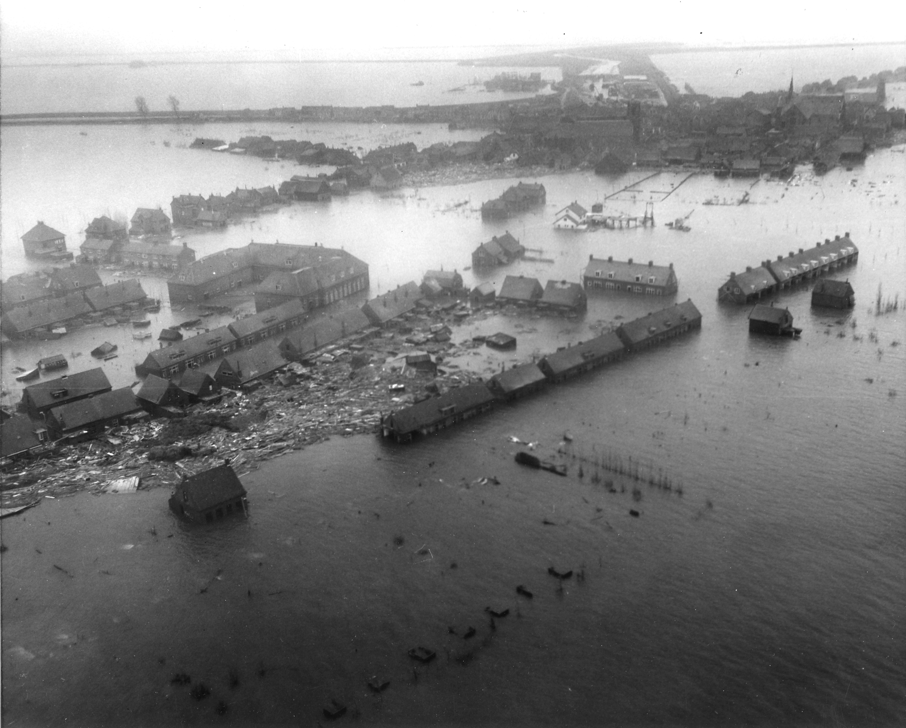
Nederlands: Luchtfoto van het overstroomde dorp Oude Tonge op Goeree-Overflakkee tijdens de Watersnoodramp van 1953. Foto gemaakt vanuit een U.S. Army helicopter.
English: Netherlands. Viewed from a U.S. Army helicopter, gives a hint of the tremendous damage wrought by the flood to Dutch islands. NB Original caption ("Zuid Beveland town") was a false determination of the location, it is actually Oude-Tonge on the island of Goeree-Overflakkee. |
|||
| Dyddiad | ||||
| Ffynhonnell |
|
|||
| Awdur | Agency for International Development |
Trwyddedu
This work is in the public domain in the United States because it is a work prepared by an officer or employee of the United States Government as part of that person’s official duties under the terms of Title 17, Chapter 1, Section 105 of the US Code.
Note: This only applies to original works of the Federal Government and not to the work of any individual U.S. state, territory, commonwealth, county, municipality, or any other subdivision. This template also does not apply to postage stamp designs published by the United States Postal Service since 1978. (See § 313.6(C)(1) of Compendium of U.S. Copyright Office Practices). It also does not apply to certain US coins; see The US Mint Terms of Use.
|
 | |
| Canfyddwyd bod y ffeil yn rhydd o gyfyngiadau yn ôl cyfraith hawlfraint, gan gynnwys pob hawl perthynol a chyfagos. | ||
Hanes y ffeil
Cliciwch ar ddyddiad / amser i weld y ffeil fel ag yr oedd bryd hynny.
| Dyddiad / Amser | Bawdlun | Hyd a lled | Defnyddiwr | Sylw | |
|---|---|---|---|---|---|
| cyfredol | 23:36, 20 Hydref 2009 | | 2,943 × 2,366 (1.94 MB) | Pieter Kuiper | better resolution from http://narademo.umiacs.umd.edu/cgi-bin/isadg/viewobject.pl?object=78667 |
| 20:38, 16 Awst 2008 |  | 600 × 484 (67 KB) | Pieter Kuiper | {{Information |Description={{en|1=Netherlands. Viewed from a U.S. Army helicopter, a Zuid Beveland town gives a hint of the tremendous damage wrought by the flood to Dutch islands.}} |Source=[http://www.archives.gov/ NARA], ARC Identifier 541705 / Local I |
Cysylltiadau'r ffeil
Mae'r 1 tudalennau a ddefnyddir isod yn cysylltu i'r ddelwedd hon:
Defnydd cydwici y ffeil
Mae'r wicis eraill hyn yn defnyddio'r ffeil hon:
- Y defnydd ar ar.wikipedia.org
- Y defnydd ar arz.wikipedia.org
- Y defnydd ar br.wikipedia.org
- Y defnydd ar ca.wikipedia.org
- Y defnydd ar cs.wikipedia.org
- Y defnydd ar de.wikipedia.org
- Y defnydd ar en.wikipedia.org
- Y defnydd ar eo.wikipedia.org
- Y defnydd ar es.wikipedia.org
- Y defnydd ar fa.wikipedia.org
- Y defnydd ar fi.wikipedia.org
- Y defnydd ar fr.wikipedia.org
- Y defnydd ar fy.wikipedia.org
- Y defnydd ar gl.wikipedia.org
- Y defnydd ar he.wikipedia.org
- Y defnydd ar hr.wikipedia.org
- Y defnydd ar it.wikipedia.org
- Y defnydd ar ja.wikipedia.org
- Y defnydd ar ko.wikipedia.org
- Y defnydd ar lv.wikipedia.org
- Y defnydd ar ms.wikipedia.org
Gweld rhagor o'r defnydd cydwici o'r ffeil hon.