Delwedd:Indian Rebellion of 1857.jpg

Maint y rhagolwg: 713 × 599 picsel. Eglurdebau eraill: 286 × 240 picsel | 571 × 480 picsel | 914 × 768 picsel | 1,218 × 1,024 picsel | 1,959 × 1,647 picsel.
Maint llawn ((1,959 × 1,647 picsel, maint y ffeil: 2.82 MB, ffurf MIME: image/jpeg))
Crynodeb
| Disgrifiad |
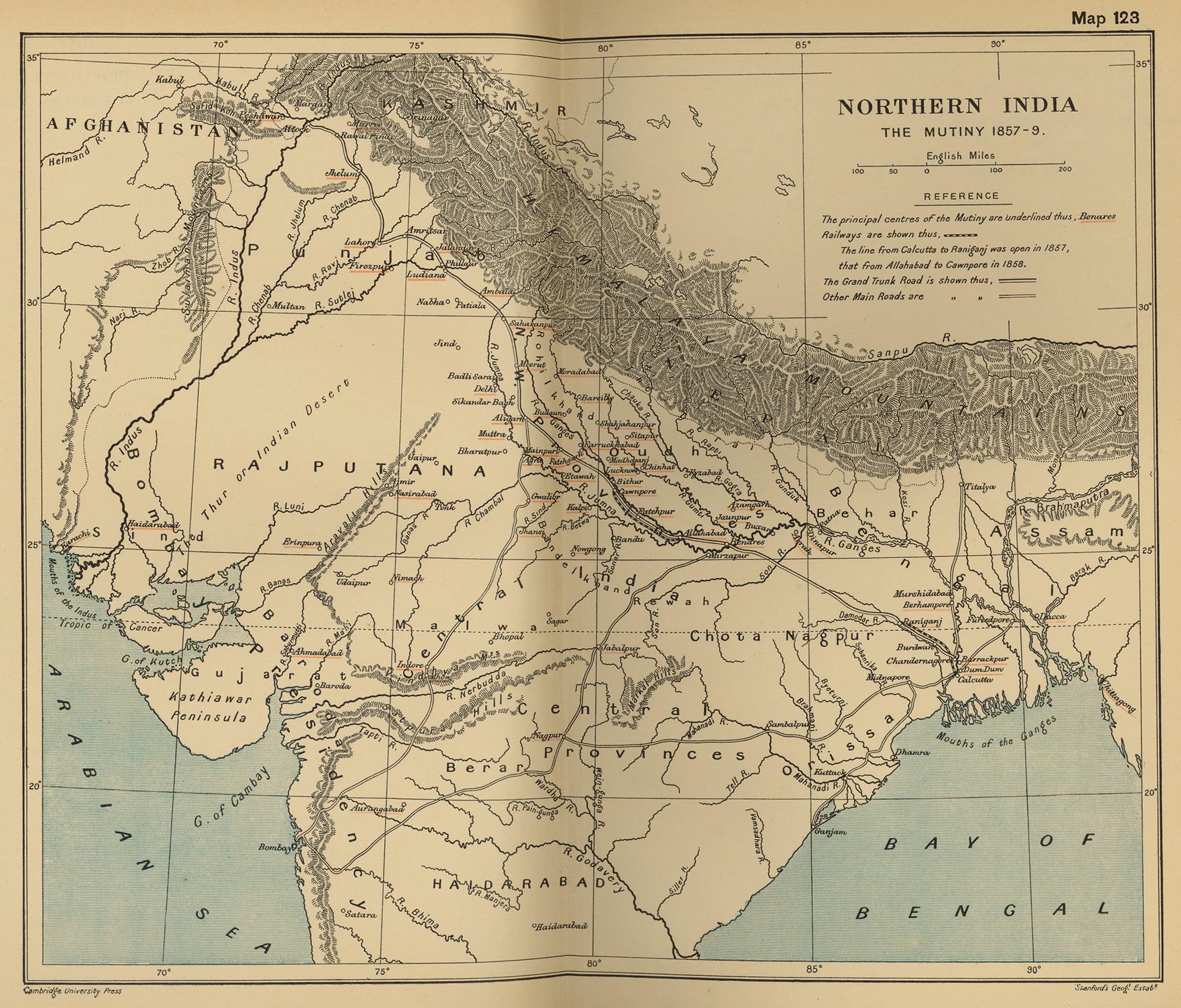
English: Map, "North India: The Mutiny 1857-9" from "The Cambridge Modern History Atlas". Cambridge University Press; London. 1912.
Editors were Sir Adolphus William Ward (†1924), G.W. Prothero (†1922), and Sir Stanley Mordaunt Leathes (†1938). Individual authors of works making up the atlas are not identified, nor are the likely to be, after reasonable research. Español: Mapa del norte de India |
|||||||||
| Dyddiad | ||||||||||
| Ffynhonnell | Perry-Castañeda Library Map Collection Website. | |||||||||
| Crëwr |
Unknown author Cambridge University Press; Stanford's Geogl. Estabt.. |
|||||||||
| Geotemporal data | ||||||||||
| Bounding box |
|
|||||||||
| Georeferencing | ||||||||||
| Diwygiadau eraill |
|
|||||||||

Trwyddedu
|
This is a faithful photographic reproduction of a two-dimensional, public domain work of art. The work of art itself is in the public domain for the following reason:
The official position taken by the Wikimedia Foundation is that "faithful reproductions of two-dimensional public domain works of art are public domain".
This photographic reproduction is therefore also considered to be in the public domain in the United States. In other jurisdictions, re-use of this content may be restricted; see Reuse of PD-Art photographs for details. | ||||
Cofnod lòg yr uwchlwythiad gwreiddiol
The original description page was on en.wikipedia (file log). All following user names refer to en.wikipedia.
- 2010-06-06 08:35 PawełMM 1959×1647× (1118753 bytes) vertical strip shadorws removed
- 2010-06-05 12:13 PawełMM 1959×1647× (1201791 bytes) central verticaly part flattened, cropped
- 2008-03-05 02:51 Fowler&fowler 1992×1700× (683065 bytes) Map, "North India: The Mutiny 1857-9" from "The Cambridge Modern History Atlas" edited by Sir Adolphus William Ward, G.W. Prothero, Sir Stanley Mordaunt Leathes, and E.A. Benians. Cambridge University Press; London. 1912. Downloaded by ~~~~ from the [h
- 2008-03-05 02:37 Fowler&fowler 1992×1700× (715404 bytes) Map, "North India: The Mutiny 1857-9" from "The Cambridge Modern History Atlas" edited by Sir Adolphus William Ward, G.W. Prothero, Sir Stanley Mordaunt Leathes, and E.A. Benians. Cambridge University Press; London. 1912. Downloaded by ~~~~ from the [h
Hanes y ffeil
Cliciwch ar ddyddiad / amser i weld y ffeil fel ag yr oedd bryd hynny.
| Dyddiad / Amser | Bawdlun | Hyd a lled | Defnyddiwr | Sylw | |
|---|---|---|---|---|---|
| cyfredol | 15:35, 11 Medi 2012 | | 1,959 × 1,647 (2.82 MB) | Yann | color balance, contrast, color corrections |
| 07:45, 18 Hydref 2010 |  | 1,959 × 1,647 (1.07 MB) | File Upload Bot (Magnus Manske) | {{BotMoveToCommons|en.wikipedia|year={{subst:CURRENTYEAR}}|month={{subst:CURRENTMONTHNAME}}|day={{subst:CURRENTDAY}}}} {{Information |Description={{en|Map, "North India: The Mutiny 1857-9" from "The Cambridge Modern History Atlas" edited by Sir Adolphus |
Cysylltiadau'r ffeil
Mae'r 1 tudalennau a ddefnyddir isod yn cysylltu i'r ddelwedd hon:
Defnydd cydwici y ffeil
Mae'r wicis eraill hyn yn defnyddio'r ffeil hon:
- Y defnydd ar ar.wikipedia.org
- Y defnydd ar ast.wikipedia.org
- Y defnydd ar azb.wikipedia.org
- Y defnydd ar bg.wikipedia.org
- Y defnydd ar bh.wikipedia.org
- Y defnydd ar bn.wikipedia.org
- Y defnydd ar br.wikipedia.org
- Y defnydd ar cs.wikipedia.org
- Y defnydd ar en.wikipedia.org
- Y defnydd ar es.wikipedia.org
- Y defnydd ar fr.wikipedia.org
- Y defnydd ar hi.wikipedia.org
- Y defnydd ar id.wikipedia.org
- Y defnydd ar io.wikipedia.org
- Y defnydd ar ja.wikipedia.org
- Y defnydd ar ka.wikipedia.org
- Y defnydd ar lv.wikipedia.org
- Y defnydd ar mai.wikipedia.org
- Y defnydd ar mr.wikipedia.org
- Y defnydd ar ms.wikipedia.org
- Y defnydd ar ne.wikipedia.org
- Y defnydd ar or.wikipedia.org
- Y defnydd ar pa.wikipedia.org
- Y defnydd ar pl.wikipedia.org
- Y defnydd ar pnb.wikipedia.org
- Y defnydd ar ru.wikipedia.org
- Y defnydd ar sd.wikipedia.org
- Y defnydd ar simple.wikipedia.org
- Y defnydd ar sr.wikipedia.org
- Y defnydd ar sv.wikipedia.org
- Y defnydd ar ta.wikipedia.org
- Y defnydd ar te.wikipedia.org
- Y defnydd ar th.wikipedia.org
- Y defnydd ar tr.wikipedia.org
- Y defnydd ar ur.wikipedia.org
Gweld rhagor o'r defnydd cydwici o'r ffeil hon.