Delwedd:Iraqi Kurdistan in Iraq (de-facto and disputed hatched).svg

Maint rhagolwg PNG o ffeil SVG yw: 589 × 600 picsel. Eglurdebau eraill: 236 × 240 picsel | 471 × 480 picsel | 754 × 768 picsel | 1,005 × 1,024 picsel | 2,011 × 2,048 picsel | 1,241 × 1,264 picsel.
Maint llawn (Ffeil SVG, maint mewn enw 1,241 × 1,264 picsel, maint y ffeil: 545 KB)
Crynodeb
| Disgrifiad |
閩南語 / Bân-lâm-gú: Kurdistan tī Iraq ê ūi-tì
Iraq koaⁿ-hong tēng ê Kurdistan Tē-he̍k #D0676F #DEA5A5 #FEFEE9 Català: Kurdistan Iraquí
Límits oficials de la regió kurda #D0676F #DEA5A5 Territory Dansk: Kort over Irakisk Kurdistan i Irak
Officielle grænser for Regionen Irakisk Kurdistan #D0676F #DEA5A5 #FEFEE9 Øvrige Deutsch: Die Lage Kurdistans im Irak
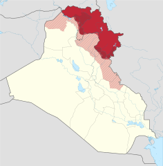
Offizielles Gebiet der Autonomen Region Kurdistan Eingegliederte Gebiete (nicht offiziell anerkannt) Von der Autonomen Region Kurdistans beanspruchte und besetzte Gebiete Von der Autonomen Region Kurdistans beanspruchte Gebiete Der Rest des Iraks Grenzen der Autonomen Region Kurdistans (inkl. der eingegliederten Gebiete) Grenze vor 2014 English: Location of Kurdistan in Iraq
Borders of the Kurdistan Region (disputed) Pre-2014 borders Recognised territory of the Kurdistan Region Disputed territory incorporated into the Kurdistan Region Other territory claimed and controlled by the Kurdistan Regional Government (approximate) Other territory claimed by the Kurdistan Regional Government Rest of Iraq Français : Le Kurdistan irakien en Irak
Frontières officielles du Kurdistan irakien #D0676F #DEA5A5 #FEFEE9 Italiano: Ubicazione del Kurdistan in Iraq
Confini della Regione del Kurdistan (contesi) Confini precedenti al 2014 Territorio riconosciuto ufficialmente della Regione del Kurdistan Territorio conteso incorporato nella Regione del Kurdistan Altri territori reclamati e amministrati dal governo regionale curdo (approssimativi) Altri territori reclamati dal governo regionale curdo Il resto dell'Iraq Magyar: Iraki Kurdisztán területe Irakon belül
Iraki Kurdisztán hivatalos területe a kurdok által elfoglalt terület (nem hivatalos) Iraki Kurdisztán által igényelt és elfoglalt terület Iraki Kurdisztán által igényelt terület Irak maradék területe Kurdisztáni Autonóm Régió határa A határ 2014 előtt Nederlands: Ligging van Koerdistan in Irak
Officiële grondgebied van Iraaks-Koerdistan #D0676F #DEA5A5 #FEFEE9 Overig Suomi: Kurdistanin sijainti Irakissa
Irakin Kurdistanin autonominen alue #D0676F #DEA5A5 #FEFEE9 Irakin Русский: Курдистан на карте Ирака
Официальные границы автономного региона Иракский Курдистан #D0676F #DEA5A5 #FEFEE9 فارسی : اقلیم کردستان عراق
منطقهٔ رسمی کردستان عراق (در دست دولت کردستان) #D0676F #DEA5A5 #FEFEE9 |
||||
| Dyddiad | |||||
| Ffynhonnell | |||||
| Awdur |
Spesh531, TUBS |
||||
| Diwygiadau eraill |
|
||||
| SVG genesis | |||||
.svg)
.svg)
.svg)
.svg)
.svg)
.svg)
.svg)

-en.svg)

.svg)
.svg)
.svg)

_(US48).svg)
_(small_islands_magnified)_(-mini_map_-rivers).svg)
.svg)
_(extra_close)_(US48).svg)
.svg)
_(zoom).svg)

.svg)


_(UNMIK).svg)
.svg)
_(disputed_hatched).svg)
_(claimed_and_disputed_hatched).svg)
.svg)
.svg)
_(%2Ball_claims_hatched).svg)

.svg)
_(shade).svg)
_(shade)_(special_marker).svg)
_(-mini_map).svg)
_(-mini_map).svg)
_(-mini_map).svg)


.svg)

.svg)
.svg)
Trwyddedu
Trwyddedir y ffeil hon yn ôl termau'r drwydded Creative Commons Attribution-Share Alike 3.0 Unported.
- Mae'n rhydd i chi:
- rhannu – gallwch gopïo, dosbarthu a throsglwyddo'r gwaith
- ailwampio – gallwch addasu'r gwaith
- Ar yr amodau canlynol:
- cydnabyddiaeth – Mae'n rhaid i chi nodi manylion y gwaith hwn, rhoi dolen i'r drwydded, a nodi os y bu golygu arni, yn y modd a benwyd gan yr awdur neu'r trwyddedwr (ond heb awgrymu o gwbl eu bod yn eich cymeradwyo chi na'ch defnydd o'r gwaith).
- rhannu ar dermau tebyg – Os byddwch yn addasu'r gwaith hwn, neu yn ei drawsnewid, neu yn adeiladu arno, mae'n rhaid i chi ddosbarthu'r gwaith dan drwydded sy'n union yr un fath same a'r gwreiddiol.
References
Official territory and governorate borders
- http://www.krso.net/Default.aspx?page=article&id=1142
- http://www.economist.com/images/20070908/CMA980.gif
Claimed territory
- http://www.aina.org/reports/pcok.pdf (page 13)
- http://www.economist.com/images/20070908/CMA980.gif
- http://photos1.blogger.com/blogger/6564/131/1600/Kurdistan_july05_claimed-767346.jpg
- http://images.fastcompany.com/magazine/144/feature-84-Kurdistan-OilMap-pop.jpg
- http://news.bbcimg.co.uk/media/images/76876000/gif/_76876578_iraq_kurdistan_624.gif
Hanes y ffeil
Cliciwch ar ddyddiad / amser i weld y ffeil fel ag yr oedd bryd hynny.
.svg&dir=prev)
.svg&offset=20170928132057)
.svg&offset=&limit=20)
.svg&offset=&limit=50)
.svg&offset=&limit=100)
.svg&offset=&limit=250)
.svg&offset=&limit=500)
| Dyddiad / Amser | Bawdlun | Hyd a lled | Defnyddiwr | Sylw | |
|---|---|---|---|---|---|
| cyfredol | 23:01, 19 Gorffennaf 2018 | | 1,241 × 1,264 (545 KB) | Rob984 | dashed official KRG border on the basis that it's disputed by Baghdad. |
| 19:05, 19 Gorffennaf 2018 |  | 1,241 × 1,264 (548 KB) | Rob984 | Also Iraqi forces took Khanaqin in October as well | |
| 18:12, 19 Gorffennaf 2018 |  | 1,241 × 1,264 (549 KB) | Rob984 | The town of Makhmur was taken over by Iraqi forces last year. Also the frontier in Kirkuk likely corresponds to the 2003 green line, not the administrative border, since Iraq only requested the Kurdish forces withdraw to the green line. | |
| 22:34, 26 Ionawr 2018 |  | 1,241 × 1,264 (549 KB) | 0ali1 | Update 26/01/2018, minor fixes | |
| 23:55, 24 Hydref 2017 |  | 1,241 × 1,264 (549 KB) | Rob984 | Federal government has reassumed control over most (if not all) of the Kirkuk province. | |
| 16:03, 24 Hydref 2017 |  | 1,241 × 1,264 (549 KB) | Rob984 | Scaled back changes around Machmur. Peshmerga have not withdrawn from the town, despite earlier reports suggesting so. | |
| 12:26, 20 Hydref 2017 |  | 1,241 × 1,264 (549 KB) | Rob984 | Update following Peshmerga withdrawal from a number of areas. Note Kurdish militias (eg PKK, YBS, etc.) have not withdrew from all areas, but they are not under KRG control. Approximate area, will need to be updated. | |
| 20:20, 12 Hydref 2017 |  | 1,241 × 1,264 (555 KB) | Spesh531 | Update now that ISIS is no longer on the Iraqi Kurdish-Iraqi proper border | |
| 14:28, 28 Medi 2017 |  | 1,241 × 1,264 (555 KB) | Rob984 | another minor fix | |
| 13:20, 28 Medi 2017 |  | 1,241 × 1,264 (555 KB) | Rob984 | minor fix |
Cysylltiadau'r ffeil
Mae'r 1 tudalennau a ddefnyddir isod yn cysylltu i'r ddelwedd hon:
Defnydd cydwici y ffeil
Mae'r wicis eraill hyn yn defnyddio'r ffeil hon:
- Y defnydd ar als.wikipedia.org
- Y defnydd ar ar.wikipedia.org
- Y defnydd ar arz.wikipedia.org
- Y defnydd ar azb.wikipedia.org
- Y defnydd ar az.wikipedia.org
- Y defnydd ar ba.wikipedia.org
- Y defnydd ar bcl.wikipedia.org
- Y defnydd ar be-tarask.wikipedia.org
- Y defnydd ar be.wikipedia.org
- Y defnydd ar bg.wikipedia.org
- Y defnydd ar bn.wikipedia.org
- Y defnydd ar br.wikipedia.org
- Y defnydd ar bs.wikipedia.org
- Y defnydd ar ceb.wikipedia.org
- Y defnydd ar ckb.wikipedia.org
- Y defnydd ar cs.wikipedia.org
- Y defnydd ar da.wikipedia.org
- Y defnydd ar de.wikipedia.org
- Y defnydd ar diq.wikipedia.org
- Y defnydd ar el.wikipedia.org
- Y defnydd ar el.wikivoyage.org
- Y defnydd ar en.wikipedia.org
- Iraqi Kurdistan
- Minorities in Iraq
- 2008 Turkish incursion into northern Iraq
- List of active separatist movements in Asia
- Disputed territories of northern Iraq
- Northern Iraq offensive (June 2014)
- Talk:Iraqi Kurdistan/Archive 2
- Ba'athist Arabization campaigns in northern Iraq
- COVID-19 pandemic in the Kurdistan Region
- Y defnydd ar eo.wikipedia.org
- Y defnydd ar es.wikipedia.org
Gweld rhagor o'r defnydd cydwici o'r ffeil hon.
.svg)
.svg)