Delwedd:Peloponnesos Map.png
Maint llawn ((808 × 852 picsel, maint y ffeil: 234 KB, ffurf MIME: image/png))
| Disgrifiad |
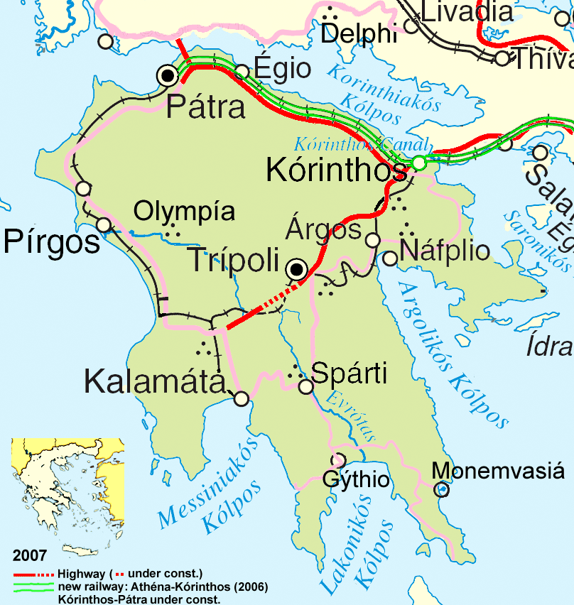
Deutsch: Wichtigste Verkehrsachsen des Peloponnes, Stand 2007.
English: Main traffic lines in the Peloponnese, as of 2007. |
| Dyddiad | |
| Ffynhonnell | see author |
| Awdur | ulrichstill |
| Diwygiadau eraill | Adapted from http://www.un.org/Depts/Cartographic/map/profile/greece.pdf |
- Mae'n rhydd i chi:
- rhannu – gallwch gopïo, dosbarthu a throsglwyddo'r gwaith
- ailwampio – gallwch addasu'r gwaith
- Ar yr amodau canlynol:
- cydnabyddiaeth – Mae'n rhaid i chi nodi manylion y gwaith hwn, rhoi dolen i'r drwydded, a nodi os y bu golygu arni, yn y modd a benwyd gan yr awdur neu'r trwyddedwr (ond heb awgrymu o gwbl eu bod yn eich cymeradwyo chi na'ch defnydd o'r gwaith).
- rhannu ar dermau tebyg – Os byddwch yn addasu'r gwaith hwn, neu yn ei drawsnewid, neu yn adeiladu arno, mae'n rhaid i chi ddosbarthu'r gwaith dan drwydded sy'n union yr un fath same a'r gwreiddiol.

| This image is a map derived from a United Nations map.
Unless stated otherwise, UN maps are to be considered in the public domain. This applies worldwide. UN maps are, in principle, open source material and you can use them in your work or for making your own map. UN requests however that you delete the UN name, logo and reference number upon any modification to the map. Content of your map will be your responsibility. You can state in your publication, if you wish, something like: based on UN map … (map name, map number, revision number and date). See: Geospatial Information Section. And: Geospatial, location data for a better world. |
 |
Hanes y ffeil
Cliciwch ar ddyddiad / amser i weld y ffeil fel ag yr oedd bryd hynny.
| Dyddiad / Amser | Bawdlun | Hyd a lled | Defnyddiwr | Sylw | |
|---|---|---|---|---|---|
| cyfredol | 17:54, 16 Ionawr 2008 | | 808 × 852 (234 KB) | Ulrichstill | {{Information| |Description= {{de|Wichtigste Verkehrsachsen des Peloponnes, Stand 2007.}} {{en|Main traffic lines in the Peloponnese, as of 2007.}} |Source= see author |Date=01.01.2008 |Author = [[:de:Benutzer:ulrich |
Cysylltiadau'r ffeil
Mae'r 1 tudalennau a ddefnyddir isod yn cysylltu i'r ddelwedd hon:
Defnydd cydwici y ffeil
Mae'r wicis eraill hyn yn defnyddio'r ffeil hon:
- Y defnydd ar als.wikipedia.org
- Y defnydd ar bg.wikipedia.org
- Y defnydd ar da.wikipedia.org
- Y defnydd ar de.wikipedia.org
- Y defnydd ar en.wikipedia.org
- Y defnydd ar et.wikipedia.org
- Y defnydd ar fr.wikipedia.org
- Y defnydd ar hr.wikipedia.org
- Y defnydd ar hyw.wikipedia.org
- Y defnydd ar id.wikipedia.org
- Y defnydd ar ja.wikipedia.org
- Y defnydd ar la.wikipedia.org
- Y defnydd ar lt.wikipedia.org
- Y defnydd ar mk.wikipedia.org
- Y defnydd ar ms.wikipedia.org
- Y defnydd ar nds.wikipedia.org
- Y defnydd ar oc.wikipedia.org
- Y defnydd ar pnb.wikipedia.org
- Y defnydd ar th.wikipedia.org
- Y defnydd ar ur.wikipedia.org
- Y defnydd ar vi.wikipedia.org
- Y defnydd ar zh-min-nan.wikipedia.org