Delwedd:Sand and gravel extraction site - geograph.org.uk - 923943.jpg
Wedi ei chwyddo hyd yr eithaf.
Sand_and_gravel_extraction_site_-_geograph.org.uk_-_923943.jpg ((640 × 480 picsel, maint y ffeil: 174 KB, ffurf MIME: image/jpeg))
Crynodeb
| Disgrifiad |
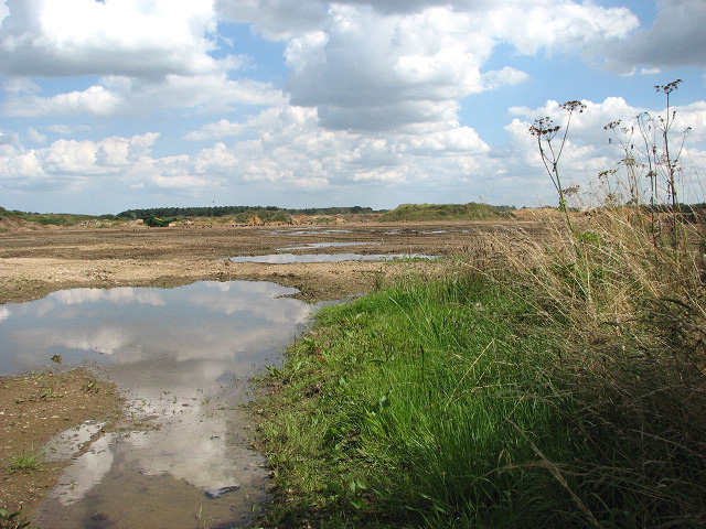
English: Sand and gravel extraction site. By Salters Lane. This gravel extraction site extends all the way along Salters Lane > 923914 until it meets Reed Lane > 923955 further to the east. Signs put up by the entrances warn that this site is not a play area > 923934. This area forms part of what used to be the parish of Launditch.
Launditch (the original spelling is Launditcth) is described in White's History, Gazetteer and Directory of Norfolk (1845) as being "of an irregular, quadrangular figure, averaging about 12 miles in length and breadth, and bounded on the north by Gallow, on the east by Eynesford, on the south by Mitford and South Greenhoe, and on the west by Freebridge-Lynn Hundred. It is a highly cultivated district, rising in some places in bold and picturesque swells, with many thriving plantations and handsome mansions, and watered by the Wensum, the Nar, and several smaller streams, which rise within its limits. It takes its name from a long ditch and bank extending from Wendling-car to the low lands near Mileham, and supposed to have been made for the purpose of carrying off the drain water. At the point where this ditch crosses the Norwich road, the Hundred court was anciently held. Launditch, (with the exception of Colkirk and Hoe) forms the Deanery of Brisley, in the Archdeaconry of Norwich." |
| Dyddiad | |
| Ffynhonnell | From geograph.org.uk |
| Awdur | Evelyn Simak |
| Cydnabyddiaeth (required by the license) | Evelyn Simak / Sand and gravel extraction site / |
| Camera location | | View this and other nearby images on: OpenStreetMap |
|---|
_heading:90.00&language=cy)
| Object location | | View this and other nearby images on: OpenStreetMap |
|---|
_heading:90.00&language=cy)
Trwyddedu

|
This image was taken from the Geograph project collection. See this photograph's page on the Geograph website for the photographer's contact details. The copyright on this image is owned by Evelyn Simak and is licensed for reuse under the Creative Commons Attribution-ShareAlike 2.0 license.
|
Trwyddedir y ffeil hon yn ôl termau'r drwydded Creative Commons Attribution-Share Alike 2.0 Generic.
Cydnabyddiaeth: Evelyn Simak
- Mae'n rhydd i chi:
- rhannu – gallwch gopïo, dosbarthu a throsglwyddo'r gwaith
- ailwampio – gallwch addasu'r gwaith
- Ar yr amodau canlynol:
- cydnabyddiaeth – Mae'n rhaid i chi nodi manylion y gwaith hwn, rhoi dolen i'r drwydded, a nodi os y bu golygu arni, yn y modd a benwyd gan yr awdur neu'r trwyddedwr (ond heb awgrymu o gwbl eu bod yn eich cymeradwyo chi na'ch defnydd o'r gwaith).
- rhannu ar dermau tebyg – Os byddwch yn addasu'r gwaith hwn, neu yn ei drawsnewid, neu yn adeiladu arno, mae'n rhaid i chi ddosbarthu'r gwaith dan drwydded sy'n union yr un fath same a'r gwreiddiol.
Hanes y ffeil
Cliciwch ar ddyddiad / amser i weld y ffeil fel ag yr oedd bryd hynny.
| Dyddiad / Amser | Bawdlun | Hyd a lled | Defnyddiwr | Sylw | |
|---|---|---|---|---|---|
| cyfredol | 03:57, 22 Chwefror 2011 | | 640 × 480 (174 KB) | GeographBot | == {{int:filedesc}} == {{Information |description={{en|1=Sand and gravel extraction site By Salters Lane. This gravel extraction site extends all the way along Salters Lane > http://www.geograph.org.uk/photo/923914 until it meets Reed Lane > http://www.ge |
Cysylltiadau'r ffeil
Mae'r 1 tudalennau a ddefnyddir isod yn cysylltu i'r ddelwedd hon:
Defnydd cydwici y ffeil
Mae'r wicis eraill hyn yn defnyddio'r ffeil hon:
- Y defnydd ar ceb.wikipedia.org
- Y defnydd ar en.wikipedia.org
- Y defnydd ar pl.wikipedia.org
- Y defnydd ar www.wikidata.org