Delwedd:St Edmund's church - geograph.org.uk - 664872.jpg
Wedi ei chwyddo hyd yr eithaf.
St_Edmund's_church_-_geograph.org.uk_-_664872.jpg ((640 × 480 picsel, maint y ffeil: 196 KB, ffurf MIME: image/jpeg))
Crynodeb
| Disgrifiad |
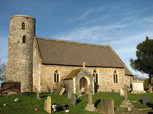
English: St Edmund's church St Edmund's church has a thatched roof, a round tower, and a tiny Norman chancel with pillar piscina, vaulted roof, sanctuary arch and small lancet windows. Outside, a trapdoor under the eaves of the chancel on the south side leads to what is traditionally called the Smuggler's Loft: brandy for the parson and tobacco for the squire. The apse is painted with the Martyrdom of King Edmund of the East Angles; the painting dates to the 12th century. A 14th century painting of St Christopher can be seen on the north wall of the nave. http://www.paintedchurch.org/frited.htm The church is open every day. |
| Dyddiad | |
| Ffynhonnell | From geograph.org.uk |
| Awdur | Evelyn Simak |
| Cydnabyddiaeth (required by the license) | Evelyn Simak / St Edmund's church / |
| Camera location | | View this and other nearby images on: OpenStreetMap |
|---|
_heading:0.00&language=cy)
| Object location | | View this and other nearby images on: OpenStreetMap |
|---|
_heading:0.00&language=cy)
Trwyddedu

|
This image was taken from the Geograph project collection. See this photograph's page on the Geograph website for the photographer's contact details. The copyright on this image is owned by Evelyn Simak and is licensed for reuse under the Creative Commons Attribution-ShareAlike 2.0 license.
|
Trwyddedir y ffeil hon yn ôl termau'r drwydded Creative Commons Attribution-Share Alike 2.0 Generic.
Cydnabyddiaeth: Evelyn Simak
- Mae'n rhydd i chi:
- rhannu – gallwch gopïo, dosbarthu a throsglwyddo'r gwaith
- ailwampio – gallwch addasu'r gwaith
- Ar yr amodau canlynol:
- cydnabyddiaeth – Mae'n rhaid i chi nodi manylion y gwaith hwn, rhoi dolen i'r drwydded, a nodi os y bu golygu arni, yn y modd a benwyd gan yr awdur neu'r trwyddedwr (ond heb awgrymu o gwbl eu bod yn eich cymeradwyo chi na'ch defnydd o'r gwaith).
- rhannu ar dermau tebyg – Os byddwch yn addasu'r gwaith hwn, neu yn ei drawsnewid, neu yn adeiladu arno, mae'n rhaid i chi ddosbarthu'r gwaith dan drwydded sy'n union yr un fath same a'r gwreiddiol.
Hanes y ffeil
Cliciwch ar ddyddiad / amser i weld y ffeil fel ag yr oedd bryd hynny.
| Dyddiad / Amser | Bawdlun | Hyd a lled | Defnyddiwr | Sylw | |
|---|---|---|---|---|---|
| cyfredol | 19:44, 7 Chwefror 2011 | | 640 × 480 (196 KB) | GeographBot | == {{int:filedesc}} == {{Information |description={{en|1=St Edmund's church St Edmund's church has a thatched roof, a round tower, and a tiny Norman chancel with pillar piscina, vaulted roof, sanctuary arch and small lancet windows. Outside, a trapdoor un |
Cysylltiadau'r ffeil
Mae'r 1 tudalennau a ddefnyddir isod yn cysylltu i'r ddelwedd hon:
Defnydd cydwici y ffeil
Mae'r wicis eraill hyn yn defnyddio'r ffeil hon:
- Y defnydd ar ceb.wikipedia.org
- Y defnydd ar en.wikipedia.org
- Y defnydd ar es.wikipedia.org
- Y defnydd ar pl.wikipedia.org
- Y defnydd ar www.wikidata.org