Delwedd:St Lawrence, Fulstow - geograph.org.uk - 433108.jpg
Wedi ei chwyddo hyd yr eithaf.
St_Lawrence,_Fulstow_-_geograph.org.uk_-_433108.jpg ((640 × 480 picsel, maint y ffeil: 81 KB, ffurf MIME: image/jpeg))
Crynodeb
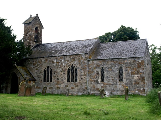
| Disgrifiad |
English: St Lawrence, Fulstow The walls of the church of St Lawrence have the remains of arcades, which point to the fact that there were north and south aisles and that this building comes from the Early English period - about 1160 to 1180. There are the remains of three bays on the outer wall of the south side and two on the north. The font is also Early English. Inside the porch entrance are two 14th century effigies of a cross-legged knight, Sir Robert de Hilton, and his lady.
On this day, a note in the porch read, "St Lawrence and Flower Cleaning Roaster." I guess it should have said, "Flower Arranging and Cleaning Roster". |
| Dyddiad | |
| Ffynhonnell | From geograph.org.uk |
| Awdur | Dave Hitchborne |
| Cydnabyddiaeth (required by the license) | Dave Hitchborne / St Lawrence, Fulstow / |
| Camera location | | View this and other nearby images on: OpenStreetMap |
|---|
_heading:337.00&language=cy)
| Object location | | View this and other nearby images on: OpenStreetMap |
|---|
_heading:337.00&language=cy)
Trwyddedu

|
This image was taken from the Geograph project collection. See this photograph's page on the Geograph website for the photographer's contact details. The copyright on this image is owned by Dave Hitchborne and is licensed for reuse under the Creative Commons Attribution-ShareAlike 2.0 license.
|
Trwyddedir y ffeil hon yn ôl termau'r drwydded Creative Commons Attribution-Share Alike 2.0 Generic.
Cydnabyddiaeth: Dave Hitchborne
- Mae'n rhydd i chi:
- rhannu – gallwch gopïo, dosbarthu a throsglwyddo'r gwaith
- ailwampio – gallwch addasu'r gwaith
- Ar yr amodau canlynol:
- cydnabyddiaeth – Mae'n rhaid i chi nodi manylion y gwaith hwn, rhoi dolen i'r drwydded, a nodi os y bu golygu arni, yn y modd a benwyd gan yr awdur neu'r trwyddedwr (ond heb awgrymu o gwbl eu bod yn eich cymeradwyo chi na'ch defnydd o'r gwaith).
- rhannu ar dermau tebyg – Os byddwch yn addasu'r gwaith hwn, neu yn ei drawsnewid, neu yn adeiladu arno, mae'n rhaid i chi ddosbarthu'r gwaith dan drwydded sy'n union yr un fath same a'r gwreiddiol.
Hanes y ffeil
Cliciwch ar ddyddiad / amser i weld y ffeil fel ag yr oedd bryd hynny.
| Dyddiad / Amser | Bawdlun | Hyd a lled | Defnyddiwr | Sylw | |
|---|---|---|---|---|---|
| cyfredol | 09:03, 4 Chwefror 2011 | | 640 × 480 (81 KB) | GeographBot | == {{int:filedesc}} == {{Information |description={{en|1=St Lawrence, Fulstow The walls of the church of St Lawrence have the remains of arcades, which point to the fact that there were north and south aisles and that this building comes from the Early En |
Cysylltiadau'r ffeil
Mae'r 1 tudalennau a ddefnyddir isod yn cysylltu i'r ddelwedd hon:
Defnydd cydwici y ffeil
Mae'r wicis eraill hyn yn defnyddio'r ffeil hon:
- Y defnydd ar ceb.wikipedia.org
- Y defnydd ar en.wikipedia.org
- Y defnydd ar es.wikipedia.org
- Y defnydd ar fa.wikipedia.org
- Y defnydd ar fr.wikipedia.org
- Y defnydd ar it.wikipedia.org
- Y defnydd ar lld.wikipedia.org
- Y defnydd ar nl.wikipedia.org
- Y defnydd ar www.wikidata.org